Property Record
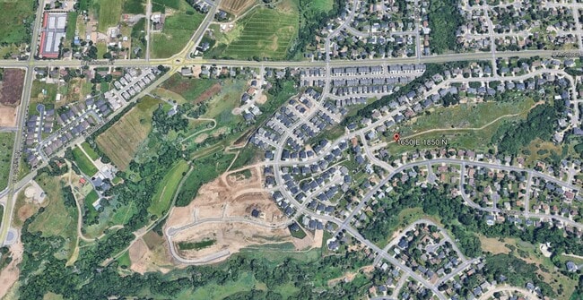
1650 E 1850 N, Layton, UT 84040

Property Detail
1650 E 1850 N
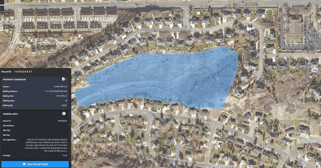
10-002-0037
BEG AT A PT ON THE S LINE OF BEECHWOOD ESTATES NO 5, SD PT BEING LOC N 89^13'30" E ALG SEC LINE 579.60 FT & S 853.59 FT FR THE N 1/4 COR OF SEC 15-T4N-R1W, SLM & RUN TH ALG THE S LINE OF BEECHWOOD EST
Residentialacreage
DAVIS
R-1-10
Utah
B and X Area of moderate flood hazard, usually the area between the limits of the 100-year and 500-year floods.
13.66 AC
2025
Davis/Weber Counties
2025
Salt Lake City
125907
Ogden, UT
NEARBY LISTINGS FOR SALE OR LEASE
DEMOGRAPHICS near 1650 E 1850 N
1 mile
3 mile
5 mile
2025 Total Population
11,633
72,240
161,182
2030 Population
11,997
74,275
168,152
Pop Growth 2025-2030
+ 3.13%
+ 2.82%
+ 4.32%
Average Age
39
37
35
2025 Total Households
3,553
24,253
51,133
HH Growth 2025-2030
+ 3.32%
+ 2.94%
+ 4.43%
Median Household Inc
$117,788
$99,876
$103,201
Avg Household Size
3.20
2.90
3.10
2025 Avg HH Vehicles
3.00
2.00
2.00
Median Home Value
$529,537
$488,489
$536,734
Median Year Built
1988
1990
1994
Nearby Places
Map Layers
Map Styles
 Street
 Aerial
Layers
 Traffic
 Biking
Places
Listings with unknown addresses are not visible on the map
- Restaurants
- Banks
- Shops
- Fitness
- Groceries
PUBLIC TRANSPORTATION
COMMUTER RAIL
Layton (FrontRunner North - Utah Transit Authority (UTA))
Drive
Walk
Distance
Layton (FrontRunner North - Utah Transit Authority (UTA))
9 min
4.0 mi
Clearfield (FrontRunner North - Utah Transit Authority (UTA))
Drive
Walk
Distance
Clearfield (FrontRunner North - Utah Transit Authority (UTA))
12 min
4.9 mi
AIRPORT
Salt Lake City International
Drive
Walk
Distance
Salt Lake City International
39 min
28.6 mi
Freight Ports
Port of Stockton
Drive
Walk
Distance
Port of Stockton
739 min
719.0 mi
SALE & LEASE HISTORY
LISTING DATE
SALE/LEASE

Mar 21, 2024
For Sale
Jun 11, 2025
For Sale
Apr 11, 2022
For Sale
Nearby Properties
Address
Land Use
TOTAL SIZE
Lot Size
Zoning
Address
Land Use
TOTAL SIZE
Lot Size
Zoning
17,930 SF
17.08 AC
RM1
Address
Land Use
TOTAL SIZE
Lot Size
Zoning
102,978 SF
6.42 AC
Address
Land Use
TOTAL SIZE
Lot Size
Zoning
6,840 SF
15.25 AC
RH
Address
Land Use
TOTAL SIZE
Lot Size
Zoning
100,348 SF
21.75 AC
R18
Address
Land Use
TOTAL SIZE
Lot Size
Zoning
348,048 SF
48.01 AC
A
Address
Land Use
TOTAL SIZE
Lot Size
Zoning
67,233 SF
32.52 AC
A1
Address
Land Use
TOTAL SIZE
Lot Size
Zoning
79,285 SF
0.01 AC
BRP
Address
Land Use
TOTAL SIZE
Lot Size
Zoning
1,484 SF
10.34 AC
Address
Land Use
TOTAL SIZE
Lot Size
Zoning
94,532 SF
7.07 AC
Address
Land Use
TOTAL SIZE
Lot Size
Zoning
4,281 SF
16.55 AC
RM1
Address
Land Use
TOTAL SIZE
Lot Size
Zoning
147,675 SF
11.25 AC
C-H
Address
Land Use
TOTAL SIZE
Lot Size
Zoning
455,336 SF
22.93 AC
Address
Land Use
TOTAL SIZE
Lot Size
Zoning
182,344 SF
7.41 AC
CP-3
Address
Land Use
TOTAL SIZE
Lot Size
Zoning
107,628 SF
58.88 AC
A
Address
Land Use
TOTAL SIZE
Lot Size
Zoning
2,373 SF
6.63 AC
RM2PRUD
Address
Land Use
TOTAL SIZE
Lot Size
Zoning
104,342 SF
18.54 AC
M2
Address
Land Use
TOTAL SIZE
Lot Size
Zoning
38,832 SF
6.82 AC
CP2
Address
Land Use
TOTAL SIZE
Lot Size
Zoning
7,672 SF
11.64 AC
RM1
Address
Land Use
TOTAL SIZE
Lot Size
Zoning
140,364 SF
6.47 AC
RH
Address
Land Use
TOTAL SIZE
Lot Size
Zoning
218,896 SF
2.76 AC
MUTOD
Address
Land Use
TOTAL SIZE
Lot Size
Zoning
1,679 SF
7.49 AC
RM2
Address
Land Use
TOTAL SIZE
Lot Size
Zoning
176,970 SF
13.58 AC
CP3
Address
Land Use
TOTAL SIZE
Lot Size
Zoning
10,412 SF
12.68 AC
CP1
Address
Land Use
TOTAL SIZE
Lot Size
Zoning
143,836 SF
3.36 AC
B-RP
Address
Land Use
TOTAL SIZE
Lot Size
Zoning
220,887 SF
12.17 AC
CH
Address
Land Use
TOTAL SIZE
Lot Size
Zoning
61,864 SF
11.66 AC
Address
Land Use
TOTAL SIZE
Lot Size
Zoning
126,304 SF
4.70 AC
BRP
Address
Land Use
TOTAL SIZE
Lot Size
Zoning
132,251 SF
7.94 AC
Address
Land Use
TOTAL SIZE
Lot Size
Zoning
20,636 SF
6.30 AC
Address
Land Use
TOTAL SIZE
Lot Size
Zoning
7,098 SF
183.50 AC
A
The World's #1 Commercial Real Estate Marketplace
Connect with us
© 2026 CoStar Group
The information above has been obtained from sources believed reliable. While we do not doubt its accuracy we have not verified it and make no guarantee, warranty or representation about it. It is your responsibility to independently confirm its accuracy and completeness. Any projections, opinions, assumptions, or estimates used are for example only and do not represent the current or future performance of the property. The value of this transaction to you depends on tax and other factors which should be evaluated by your tax, financial, and legal advisors. You and your advisors should conduct a careful, independent investigation of the property to determine to your satisfaction the suitability of the property for your needs.