Property Record
1650 Foothill Dr, Boulder City, NV 89005

Property Detail
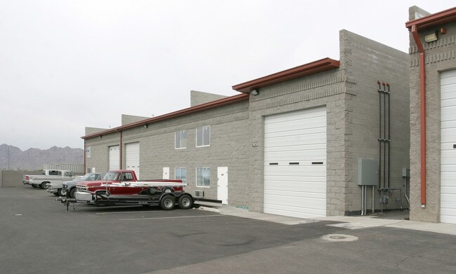
1650 Foothill Dr
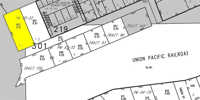
186-08-301-002
PARCEL MAP FILE 60 PAGE 22 LOT 1-1
Foodprocessing
Clark
CM
Nevada
B and X Area of moderate flood hazard, usually the area between the limits of the 100-year and 500-year floods.
1
2026
0.91 AC
2026
Outlying S Clark Cnty
005501
Las Vegas
24,821 SF
Las Vegas-Henderson-North Las Vegas, NV
NEARBY LISTINGS FOR SALE OR LEASE
-
-
View all Boulder City listings for lease on LoopNet.com
DEMOGRAPHICS near 1650 Foothill Dr
1 mile
3 mile
5 mile
2025 Total Population
2,839
15,859
26,724
2030 Population
3,006
16,763
28,332
Pop Growth 2025-2030
+ 5.88%
+ 5.70%
+ 6.02%
Average Age
52
49
46
2025 Total Households
1,411
7,087
11,304
HH Growth 2025-2030
+ 5.81%
+ 5.77%
+ 6.07%
Median Household Inc
$46,096
$76,289
$80,576
Avg Household Size
2.00
2.20
2.30
2025 Avg HH Vehicles
2.00
2.00
2.00
Median Home Value
$349,532
$471,158
$481,127
Median Year Built
1978
1980
1990
Nearby Places
Map Layers
Map Styles
 Street
 Aerial
Transit
 Traffic
 Biking
Places
Listings with unknown addresses are not visible on the map
- Restaurants
- Banks
- Shops
- Fitness
- Groceries
PUBLIC TRANSPORTATION
AIRPORT
Boulder City Municipal
Drive
Walk
Distance
Boulder City Municipal
7 min
2.5 mi
Harry Reid International
Drive
Walk
Distance
Harry Reid International
30 min
22.7 mi
Freight Ports
Port of Long Beach
Drive
Walk
Distance
Port of Long Beach
327 min
291.3 mi
SALE & LEASE HISTORY
LISTING DATE
SALE/LEASE

Feb 21, 2017
For Lease
Apr 05, 2017
For Lease
Nearby Properties
Address
Land Use
TOTAL SIZE
Lot Size
Zoning
Address
Land Use
TOTAL SIZE
Lot Size
Zoning
252,513 SF
490.45 AC
S
Address
Land Use
TOTAL SIZE
Lot Size
Zoning
30.74 AC
H
Address
Land Use
TOTAL SIZE
Lot Size
Zoning
48.81 AC
C2
Address
Land Use
TOTAL SIZE
Lot Size
Zoning
36.90 AC
GM
Address
Land Use
TOTAL SIZE
Lot Size
Zoning
51,777 SF
261.30 AC
SR
Address
Land Use
TOTAL SIZE
Lot Size
Zoning
43.62 AC
Address
Land Use
TOTAL SIZE
Lot Size
Zoning
89,666 SF
38.65 AC
R18
Address
Land Use
TOTAL SIZE
Lot Size
Zoning
29.94 AC
S
Address
Land Use
TOTAL SIZE
Lot Size
Zoning
73,468 SF
11.34 AC
H
Address
Land Use
TOTAL SIZE
Lot Size
Zoning
32,996 SF
23.62 AC
Address
Land Use
TOTAL SIZE
Lot Size
Zoning
Address
Land Use
TOTAL SIZE
Lot Size
Zoning
22.31 AC
GM
Address
Land Use
TOTAL SIZE
Lot Size
Zoning
8,203 SF
14.87 AC
Address
Land Use
TOTAL SIZE
Lot Size
Zoning
61,720 SF
6.39 AC
H
Address
Land Use
TOTAL SIZE
Lot Size
Zoning
51,423 SF
4.01 AC
Address
Land Use
TOTAL SIZE
Lot Size
Zoning
150.88 AC
S
Address
Land Use
TOTAL SIZE
Lot Size
Zoning
53,578 SF
1.35 AC
C2
Address
Land Use
TOTAL SIZE
Lot Size
Zoning
79.22 AC
GM
Address
Land Use
TOTAL SIZE
Lot Size
Zoning
48,033 SF
4.89 AC
C2
Address
Land Use
TOTAL SIZE
Lot Size
Zoning
18,592 SF
8.76 AC
R17
Address
Land Use
TOTAL SIZE
Lot Size
Zoning
5,238 SF
5.97 AC
C2
Address
Land Use
TOTAL SIZE
Lot Size
Zoning
61,972 SF
3.85 AC
C2
Address
Land Use
TOTAL SIZE
Lot Size
Zoning
94,810 SF
3.65 AC
C2
Address
Land Use
TOTAL SIZE
Lot Size
Zoning
13.88 AC
CM
Address
Land Use
TOTAL SIZE
Lot Size
Zoning
Address
Land Use
TOTAL SIZE
Lot Size
Zoning
9.93 AC
GP
Address
Land Use
TOTAL SIZE
Lot Size
Zoning
4,806 SF
11.86 AC
RV
Address
Land Use
TOTAL SIZE
Lot Size
Zoning
3,268 SF
0.65 AC
C2
Address
Land Use
TOTAL SIZE
Lot Size
Zoning
12.90 AC
CM
Address
Land Use
TOTAL SIZE
Lot Size
Zoning
9,600 SF
4.37 AC
GM
The World's #1 Commercial Real Estate Marketplace
Connect with us
© 2026 CoStar Group
The information above has been obtained from sources believed reliable. While we do not doubt its accuracy we have not verified it and make no guarantee, warranty or representation about it. It is your responsibility to independently confirm its accuracy and completeness. Any projections, opinions, assumptions, or estimates used are for example only and do not represent the current or future performance of the property. The value of this transaction to you depends on tax and other factors which should be evaluated by your tax, financial, and legal advisors. You and your advisors should conduct a careful, independent investigation of the property to determine to your satisfaction the suitability of the property for your needs.