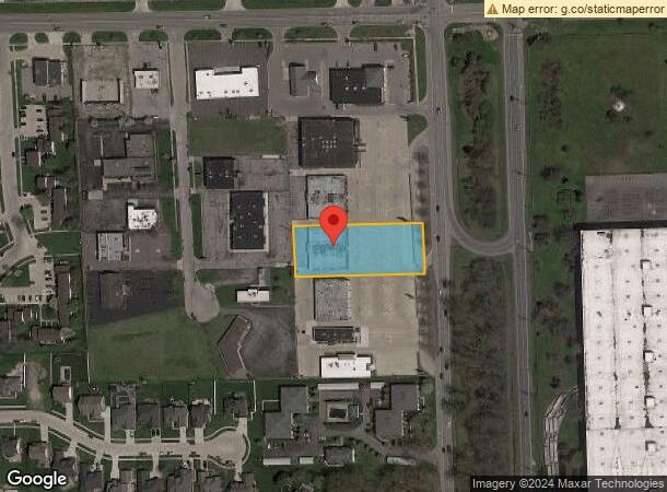
Property Record
1650 Fort St, Trenton, MI 48183

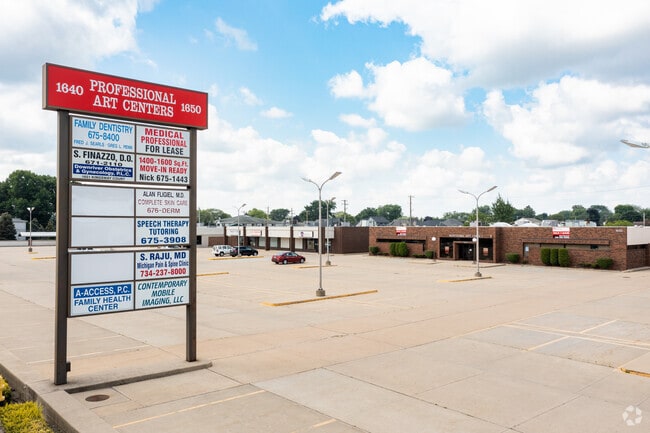
This Property Is For Sale
Current Lease Availabilities
NEARBY LISTINGS FOR SALE OR LEASE
Property Detail
1650 Fort St
Detroit-Warren-Dearborn, MI
Fort King
54-005-06-0007-000
13S7 LOT 7 FORT KING SUB T4S R10E L92 P38 TO 40 WCR
Medicalbuilding
Wayne
X
Michigan
26163C0414E
7
2025
1.09 AC
2025
Downriver South
594100
Detroit
11,024 SF
DEMOGRAPHICS near 1650 Fort St
1 Mile
3 Mile
5 Mile
2024 Total Population
8,302
50,553
126,127
2029 Population
7,963
48,440
120,941
Pop Growth 2024-2029
(4.08%)
(4.18%)
(4.11%)
Average Age
45
45
43
2024 Total Households
3,695
21,917
54,014
HH Growth 2024-2029
(4.11%)
(4.20%)
(4.15%)
Median Household Inc
$72,673
$74,082
$70,736
Avg Household Size
2.20
2.30
2.30
2024 Avg HH Vehicles
2.00
2.00
2.00
Median Home Value
$218,886
$193,188
$180,098
Median Year Built
1966
1966
1966
Nearby Places
Map Layers
Map Styles
 Street
 Aerial
- Restaurants
- Banks
- Shops
- Fitness
- Groceries
PUBLIC TRANSPORTATION
AIRPORT
Detroit Metro Wayne County
DRIVE
WALK
Distance
Detroit Metro Wayne County
30 min
15.3 mi
Windsor International
DRIVE
WALK
Distance
Windsor International
49 min
26.4 mi
Nearby Properties
Address
Land Use
TOTAL SIZE
Lot Size
Zoning
Address
Land Use
TOTAL SIZE
Lot Size
Zoning
2,651,867 SF
137.23 AC
I-3
Address
Land Use
TOTAL SIZE
Lot Size
Zoning
1,981,391 SF
166.35 AC
I-2
Address
Land Use
TOTAL SIZE
Lot Size
Zoning
2,193,696 SF
182.23 AC
Address
Land Use
TOTAL SIZE
Lot Size
Zoning
155,600 SF
83.84 AC
R1
Address
Land Use
TOTAL SIZE
Lot Size
Zoning
729,040 SF
45.85 AC
I-2
Address
Land Use
TOTAL SIZE
Lot Size
Zoning
150,224 SF
15.45 AC
RM-1
Address
Land Use
TOTAL SIZE
Lot Size
Zoning
247,238 SF
21.39 AC
I-1
Address
Land Use
TOTAL SIZE
Lot Size
Zoning
220,869 SF
25.31 AC
C-2 GEN BU
Address
Land Use
TOTAL SIZE
Lot Size
Zoning
122,430 SF
22.24 AC
Address
Land Use
TOTAL SIZE
Lot Size
Zoning
209,221 SF
21.80 AC
Address
Land Use
TOTAL SIZE
Lot Size
Zoning
211,389 SF
41.38 AC
Address
Land Use
TOTAL SIZE
Lot Size
Zoning
10.66 AC
RM MULTI F
Address
Land Use
TOTAL SIZE
Lot Size
Zoning
42.98 AC
Address
Land Use
TOTAL SIZE
Lot Size
Zoning
252,833 SF
34.40 AC
RM1-MUL
Address
Land Use
TOTAL SIZE
Lot Size
Zoning
240,852 SF
15.44 AC
RM MULTI F
Address
Land Use
TOTAL SIZE
Lot Size
Zoning
178,682 SF
19.23 AC
Address
Land Use
TOTAL SIZE
Lot Size
Zoning
217,548 SF
6.82 AC
RM MULTI F
Address
Land Use
TOTAL SIZE
Lot Size
Zoning
92,397 SF
12.63 AC
PUD
Address
Land Use
TOTAL SIZE
Lot Size
Zoning
125,828 SF
8.17 AC
B-2 COM
Address
Land Use
TOTAL SIZE
Lot Size
Zoning
2,160 SF
334.88 AC
I1
Address
Land Use
TOTAL SIZE
Lot Size
Zoning
84,860 SF
9.13 AC
C-2 GEN BU
Address
Land Use
TOTAL SIZE
Lot Size
Zoning
143,496 SF
3.73 AC
RM-2
Address
Land Use
TOTAL SIZE
Lot Size
Zoning
148,815 SF
9.11 AC
RM MULTI F
Address
Land Use
TOTAL SIZE
Lot Size
Zoning
202,349 SF
14.33 AC
RM MULTI F
Address
Land Use
TOTAL SIZE
Lot Size
Zoning
255,456 SF
7.74 AC
I-1
Address
Land Use
TOTAL SIZE
Lot Size
Zoning
169,192 SF
11.90 AC
R1
Address
Land Use
TOTAL SIZE
Lot Size
Zoning
230,789 SF
9.98 AC
Address
Land Use
TOTAL SIZE
Lot Size
Zoning
196,714 SF
20.43 AC
Address
Land Use
TOTAL SIZE
Lot Size
Zoning
2,368 SF
32.58 AC
Address
Land Use
TOTAL SIZE
Lot Size
Zoning
301,644 SF
14.22 AC
I-1
The World's #1 Commercial Real Estate Marketplace
Connect with us
© 2026 CoStar Group
The information above has been obtained from sources believed reliable. While we do not doubt its accuracy we have not verified it and make no guarantee, warranty or representation about it. It is your responsibility to independently confirm its accuracy and completeness. Any projections, opinions, assumptions, or estimates used are for example only and do not represent the current or future performance of the property. The value of this transaction to you depends on tax and other factors which should be evaluated by your tax, financial, and legal advisors. You and your advisors should conduct a careful, independent investigation of the property to determine to your satisfaction the suitability of the property for your needs.