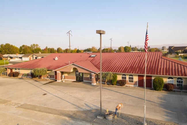
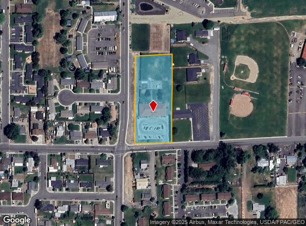
Property Record
1650 North Ave, Sunnyside, WA 98944
NEARBY LISTINGS FOR SALE OR LEASE
-
-
View all Sunnyside listings for sale on LoopNet.com
Property Detail
1650 North Ave
231019-33003
W 226.15 FT OF S1/2 SW1/4 SW1/4 EX W 5 FT ROAD & EX N 153 FT
Publichealthcarefacility
Yakima
X
Washington
53077C1925D
2.19 AC
2025
Outlying Yakima County
2025
Yakima
002003
Yakima, WA
9,242 SF
DEMOGRAPHICS near 1650 North Ave
1 Mile
3 Mile
5 Mile
2024 Total Population
7,242
20,717
23,970
2029 Population
7,249
20,742
23,931
Pop Growth 2024-2029
+ 0.10%
+ 0.12%
(0.16%)
Average Age
32
32
33
2024 Total Households
2,044
5,843
6,766
HH Growth 2024-2029
0.00%
+ 0.03%
(0.27%)
Median Household Inc
$49,912
$49,536
$51,470
Avg Household Size
3.50
3.50
3.50
2024 Avg HH Vehicles
2.00
3.00
3.00
Median Home Value
$153,400
$197,278
$202,972
Median Year Built
1974
1974
1973
Nearby Places
Map Layers
Map Styles
 Street
 Aerial
- Restaurants
- Banks
- Shops
- Fitness
- Groceries
PUBLIC TRANSPORTATION
AIRPORT
Yakima Air Trml/McAllister Field
DRIVE
WALK
Distance
Yakima Air Trml/McAllister Field
46 min
35.3 mi
SALE & LEASE HISTORY
LISTING DATE
SALE/LEASE

Oct 07, 2020
For Sale
Nearby Properties
Address
Land Use
TOTAL SIZE
Lot Size
Zoning
Address
Land Use
TOTAL SIZE
Lot Size
Zoning
504,969 SF
75.89 AC
PF
Address
Land Use
TOTAL SIZE
Lot Size
Zoning
136,437 SF
14.46 AC
PF
Address
Land Use
TOTAL SIZE
Lot Size
Zoning
92,281 SF
18.90 AC
PF
Address
Land Use
TOTAL SIZE
Lot Size
Zoning
76,449 SF
2.78 AC
PB
Address
Land Use
TOTAL SIZE
Lot Size
Zoning
187,651 SF
18.17 AC
M2
Address
Land Use
TOTAL SIZE
Lot Size
Zoning
65,578 SF
41.08 AC
PF
Address
Land Use
TOTAL SIZE
Lot Size
Zoning
272,152 SF
17.57 AC
M1
Address
Land Use
TOTAL SIZE
Lot Size
Zoning
224,160 SF
8.53 AC
M2
Address
Land Use
TOTAL SIZE
Lot Size
Zoning
155,600 SF
17.44 AC
B2
Address
Land Use
TOTAL SIZE
Lot Size
Zoning
83,940 SF
28.15 AC
PF
Address
Land Use
TOTAL SIZE
Lot Size
Zoning
17,861 SF
7.03 AC
R2
Address
Land Use
TOTAL SIZE
Lot Size
Zoning
113,242 SF
12.92 AC
M1
Address
Land Use
TOTAL SIZE
Lot Size
Zoning
133,376 SF
11.48 AC
B1
Address
Land Use
TOTAL SIZE
Lot Size
Zoning
110,860 SF
7.49 AC
M1
Address
Land Use
TOTAL SIZE
Lot Size
Zoning
36,382 SF
5 AC
R1
Address
Land Use
TOTAL SIZE
Lot Size
Zoning
268,860 SF
12.15 AC
M2
Address
Land Use
TOTAL SIZE
Lot Size
Zoning
52,132 SF
4.74 AC
R2
Address
Land Use
TOTAL SIZE
Lot Size
Zoning
26,021 SF
10.12 AC
PF
Address
Land Use
TOTAL SIZE
Lot Size
Zoning
50,548 SF
0.97 AC
R3
Address
Land Use
TOTAL SIZE
Lot Size
Zoning
23,570 SF
9.37 AC
PUB
Address
Land Use
TOTAL SIZE
Lot Size
Zoning
134,029 SF
7.19 AC
B2
Address
Land Use
TOTAL SIZE
Lot Size
Zoning
39,183 SF
9.17 AC
B1
Address
Land Use
TOTAL SIZE
Lot Size
Zoning
29,120 SF
1.94 AC
R3
Address
Land Use
TOTAL SIZE
Lot Size
Zoning
15,432 SF
21.94 AC
M2
Address
Land Use
TOTAL SIZE
Lot Size
Zoning
96,195 SF
6.28 AC
B2
Address
Land Use
TOTAL SIZE
Lot Size
Zoning
10,433 SF
25.30 AC
PF
Address
Land Use
TOTAL SIZE
Lot Size
Zoning
31,724 SF
1.40 AC
R2
Address
Land Use
TOTAL SIZE
Lot Size
Zoning
50,004 SF
1.62 AC
B1
Address
Land Use
TOTAL SIZE
Lot Size
Zoning
38,396 SF
2.10 AC
B3
Address
Land Use
TOTAL SIZE
Lot Size
Zoning
39,050 SF
2.50 AC
R3
The World's #1 Commercial Real Estate Marketplace
Connect with us
© 2026 CoStar Group
The information above has been obtained from sources believed reliable. While we do not doubt its accuracy we have not verified it and make no guarantee, warranty or representation about it. It is your responsibility to independently confirm its accuracy and completeness. Any projections, opinions, assumptions, or estimates used are for example only and do not represent the current or future performance of the property. The value of this transaction to you depends on tax and other factors which should be evaluated by your tax, financial, and legal advisors. You and your advisors should conduct a careful, independent investigation of the property to determine to your satisfaction the suitability of the property for your needs.