Property Record
1650 Response Rd, Sacramento, CA 95815
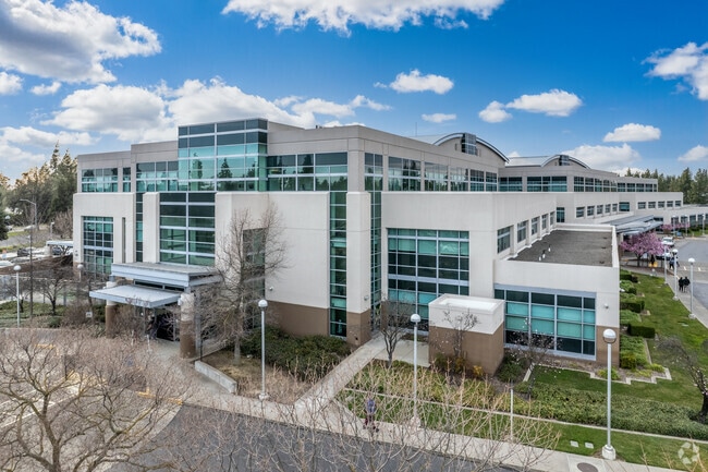

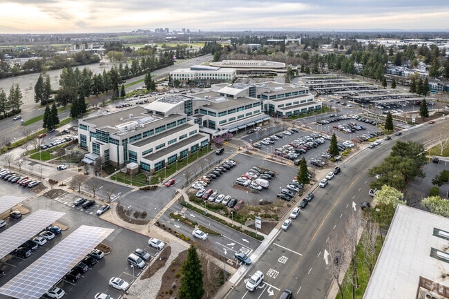
Property Detail
1650 Response Rd
Sacramento-Roseville-Folsom, CA
PARCEL MAP, LOT 2
277-0273-003
Sacramento
Medicalbuilding
California
OB-PUD
2
2025
15.73 AC
2025
Point West
005402
Sacramento
226,731 SF
NEARBY LISTINGS FOR SALE OR LEASE
-
-
View all Sacramento listings for sale on LoopNet.com
DEMOGRAPHICS near 1650 Response Rd
1 mile
3 mile
5 mile
2025 Total Population
8,569
160,368
411,061
2030 Population
8,776
162,942
417,984
Pop Growth 2025-2030
+ 2.42%
+ 1.61%
+ 1.68%
Average Age
35
38
39
2025 Total Households
3,318
62,619
162,758
HH Growth 2025-2030
+ 2.26%
+ 1.68%
+ 1.85%
Median Household Inc
$59,543
$74,077
$79,074
Avg Household Size
2.50
2.40
2.40
2025 Avg HH Vehicles
1.00
2.00
2.00
Median Home Value
$337,647
$569,118
$522,293
Median Year Built
1971
1964
1968
Nearby Places
Map Layers
Map Styles
 Street
 Aerial
Layers
 Traffic
 Biking
Places
Listings with unknown addresses are not visible on the map
- Restaurants
- Banks
- Shops
- Fitness
- Groceries
PUBLIC TRANSPORTATION
COMMUTER RAIL
Drive
Walk
Distance
9 min
5.4 mi
AIRPORT
Sacramento International
Drive
Walk
Distance
Sacramento International
22 min
13.7 mi
Freight Ports
Port of Stockton
Drive
Walk
Distance
Port of Stockton
62 min
51.8 mi
Nearby Properties
Address
Land Use
TOTAL SIZE
Lot Size
Zoning
Address
Land Use
TOTAL SIZE
Lot Size
Zoning
1,095,507 SF
1.39 AC
H-SPD C-2-
Address
Land Use
TOTAL SIZE
Lot Size
Zoning
10.28 AC
H
Address
Land Use
TOTAL SIZE
Lot Size
Zoning
201,132 SF
28.11 AC
C-2
Address
Land Use
TOTAL SIZE
Lot Size
Zoning
756,831 SF
1.39 AC
C-2-SPD
Address
Land Use
TOTAL SIZE
Lot Size
Zoning
490,607 SF
32.63 AC
RD-30
Address
Land Use
TOTAL SIZE
Lot Size
Zoning
2.87 AC
C-2
Address
Land Use
TOTAL SIZE
Lot Size
Zoning
31,163 SF
1.57 AC
C-2-TO-SPD
Address
Land Use
TOTAL SIZE
Lot Size
Zoning
10.49 AC
C-2
Address
Land Use
TOTAL SIZE
Lot Size
Zoning
319,856 SF
12.27 AC
R-3-R-PUD
Address
Land Use
TOTAL SIZE
Lot Size
Zoning
0.65 AC
C-4-SPD
Address
Land Use
TOTAL SIZE
Lot Size
Zoning
390,860 SF
20.17 AC
R-3-R-PUD
Address
Land Use
TOTAL SIZE
Lot Size
Zoning
383,000 SF
25.52 AC
M-1
Address
Land Use
TOTAL SIZE
Lot Size
Zoning
179,178 SF
3.35 AC
RO
Address
Land Use
TOTAL SIZE
Lot Size
Zoning
148,642 SF
7.15 AC
RD-30
Address
Land Use
TOTAL SIZE
Lot Size
Zoning
335,346 SF
16.65 AC
SC-R-PUD
Address
Land Use
TOTAL SIZE
Lot Size
Zoning
420,421 SF
25.39 AC
BP
Address
Land Use
TOTAL SIZE
Lot Size
Zoning
258,252 SF
1.66 AC
C-2-SPD
Address
Land Use
TOTAL SIZE
Lot Size
Zoning
190,723 SF
9.10 AC
RD-30
Address
Land Use
TOTAL SIZE
Lot Size
Zoning
141,251 SF
4.86 AC
C-2-SPD RM
Address
Land Use
TOTAL SIZE
Lot Size
Zoning
156,649 SF
6.14 AC
LC
Address
Land Use
TOTAL SIZE
Lot Size
Zoning
1,281 SF
0.42 AC
RD-20
Address
Land Use
TOTAL SIZE
Lot Size
Zoning
91,185 SF
1.37 AC
C-2-SPD
Address
Land Use
TOTAL SIZE
Lot Size
Zoning
171,405 SF
13.80 AC
R-1
Address
Land Use
TOTAL SIZE
Lot Size
Zoning
74,008 SF
6.78 AC
H-PC
Address
Land Use
TOTAL SIZE
Lot Size
Zoning
82,936 SF
7.66 AC
SC-PUD
Address
Land Use
TOTAL SIZE
Lot Size
Zoning
136,152 SF
13.40 AC
AC LC
Address
Land Use
TOTAL SIZE
Lot Size
Zoning
168,560 SF
8.95 AC
RD-30
Address
Land Use
TOTAL SIZE
Lot Size
Zoning
152,000 SF
12.88 AC
SPA
Address
Land Use
TOTAL SIZE
Lot Size
Zoning
128,950 SF
0.75 AC
RMX-TO-SPD
The World's #1 Commercial Real Estate Marketplace
Connect with us
© 2026 CoStar Group
The information above has been obtained from sources believed reliable. While we do not doubt its accuracy we have not verified it and make no guarantee, warranty or representation about it. It is your responsibility to independently confirm its accuracy and completeness. Any projections, opinions, assumptions, or estimates used are for example only and do not represent the current or future performance of the property. The value of this transaction to you depends on tax and other factors which should be evaluated by your tax, financial, and legal advisors. You and your advisors should conduct a careful, independent investigation of the property to determine to your satisfaction the suitability of the property for your needs.