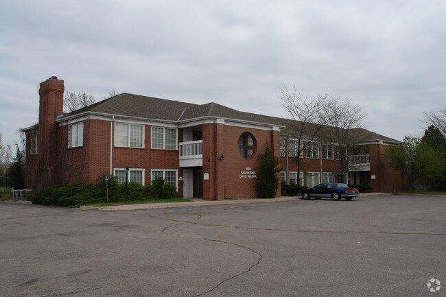
Property Record
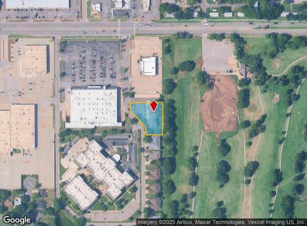
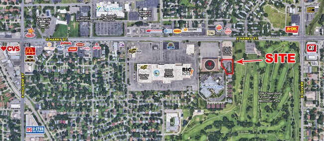
1650 S Georgetown St, Wichita, KS 67218
NEARBY LISTINGS FOR SALE OR LEASE
Property Detail
1650 S Georgetown St
Wichita, KS
Georgetown Ii Add
127-35-0-12-01-003.00
LOT 3 BLOCK 2 GEORGETOWN II ADD.
Apartment
Sedgwick
X
Kansas
20173C0366G
3
2024
0.70 AC
2025
Southeast
006300
Wichita
12,800 SF
DEMOGRAPHICS near 1650 S Georgetown St
1 Mile
3 Mile
5 Mile
2024 Total Population
17,083
100,345
219,991
2029 Population
17,694
103,367
226,370
Pop Growth 2024-2029
+ 3.58%
+ 3.01%
+ 2.90%
Average Age
38
37
37
2024 Total Households
7,180
41,844
89,499
HH Growth 2024-2029
+ 3.57%
+ 2.93%
+ 2.90%
Median Household Inc
$37,290
$45,968
$45,810
Avg Household Size
2.20
2.30
2.30
2024 Avg HH Vehicles
1.00
2.00
2.00
Median Home Value
$80,187
$107,639
$113,434
Median Year Built
1956
1956
1961
Nearby Places
Map Layers
Map Styles
 Street
 Aerial
- Restaurants
- Banks
- Shops
- Fitness
- Groceries
PUBLIC TRANSPORTATION
AIRPORT
Wichita Dwight D Eisenhower Ntl
DRIVE
WALK
Distance
Wichita Dwight D Eisenhower Ntl
18 min
10.5 mi
SALE & LEASE HISTORY
LISTING DATE
SALE/LEASE

Sep 25, 2016
For Lease
Sep 24, 2016
For Sale
Nov 12, 2024
For Sale
Jul 18, 2018
For Sale
Jan 31, 2019
For Sale
Nearby Properties
Address
Land Use
TOTAL SIZE
Lot Size
Zoning
Address
Land Use
TOTAL SIZE
Lot Size
Zoning
468,755 SF
10.41 AC
CBD,LI
Address
Land Use
TOTAL SIZE
Lot Size
Zoning
430,593 SF
11.89 AC
GO,LC
Address
Land Use
TOTAL SIZE
Lot Size
Zoning
576,707 SF
53.70 AC
B,LC
Address
Land Use
TOTAL SIZE
Lot Size
Zoning
271,541 SF
39.20 AC
GO
Address
Land Use
TOTAL SIZE
Lot Size
Zoning
237,087 SF
48.33 AC
B
Address
Land Use
TOTAL SIZE
Lot Size
Zoning
418.47 AC
AFB
Address
Land Use
TOTAL SIZE
Lot Size
Zoning
197,464 SF
4.05 AC
CBD
Address
Land Use
TOTAL SIZE
Lot Size
Zoning
527,510 SF
50.27 AC
TF-3
Address
Land Use
TOTAL SIZE
Lot Size
Zoning
167,304 SF
6.19 AC
MF-29
Address
Land Use
TOTAL SIZE
Lot Size
Zoning
152,978 SF
7.86 AC
LI
Address
Land Use
TOTAL SIZE
Lot Size
Zoning
3,063,858 SF
57.81 AC
LI
Address
Land Use
TOTAL SIZE
Lot Size
Zoning
945,203 SF
9.53 AC
GO
Address
Land Use
TOTAL SIZE
Lot Size
Zoning
108,232 SF
3.72 AC
PUD
Address
Land Use
TOTAL SIZE
Lot Size
Zoning
167,315 SF
2 AC
LC,SF-5
Address
Land Use
TOTAL SIZE
Lot Size
Zoning
728,346 SF
33.17 AC
LC
Address
Land Use
TOTAL SIZE
Lot Size
Zoning
84,788 SF
5.98 AC
PUD
Address
Land Use
TOTAL SIZE
Lot Size
Zoning
81,870 SF
3.70 AC
B,GC
Address
Land Use
TOTAL SIZE
Lot Size
Zoning
87,108 SF
4.09 AC
LC,SF-5
Address
Land Use
TOTAL SIZE
Lot Size
Zoning
106,159 SF
16.16 AC
SF-5
Address
Land Use
TOTAL SIZE
Lot Size
Zoning
112,088 SF
4.05 AC
SF-5,B
Address
Land Use
TOTAL SIZE
Lot Size
Zoning
71,568 SF
4.83 AC
TF-3
Address
Land Use
TOTAL SIZE
Lot Size
Zoning
98,077 SF
10.92 AC
SF-5
Address
Land Use
TOTAL SIZE
Lot Size
Zoning
119,245 SF
10.77 AC
MF29
Address
Land Use
TOTAL SIZE
Lot Size
Zoning
64,218 SF
5.76 AC
TF-3
Address
Land Use
TOTAL SIZE
Lot Size
Zoning
64,650 SF
3.57 AC
CBD
Address
Land Use
TOTAL SIZE
Lot Size
Zoning
62,775 SF
4.73 AC
SF-5
Address
Land Use
TOTAL SIZE
Lot Size
Zoning
80,150 SF
3.76 AC
TF-3
Address
Land Use
TOTAL SIZE
Lot Size
Zoning
75,932 SF
5.46 AC
SF-5
The World's #1 Commercial Real Estate Marketplace
Connect with us
© 2025 CoStar Group
The information above has been obtained from sources believed reliable. While we do not doubt its accuracy we have not verified it and make no guarantee, warranty or representation about it. It is your responsibility to independently confirm its accuracy and completeness. Any projections, opinions, assumptions, or estimates used are for example only and do not represent the current or future performance of the property. The value of this transaction to you depends on tax and other factors which should be evaluated by your tax, financial, and legal advisors. You and your advisors should conduct a careful, independent investigation of the property to determine to your satisfaction the suitability of the property for your needs.