Property Record
Highway 181, Portland, TX 78374


NEARBY LISTINGS FOR SALE OR LEASE
Property Detail
Highway 181
Corpus Christi, TX
North Shore Unit 3
42269
NORTH SHORE UNIT 3 BLK 14 LOT 18R (2.14 AC)
Commercialnec
San Patricio
X
Texas
48409C0275E
18r
2024
2.14 AC
2025
Portland/Ingleside
010601
Corpus Christi
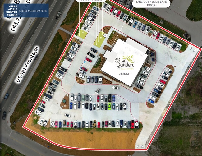
7,732 SF
DEMOGRAPHICS near Highway 181
1 Mile
3 Mile
5 Mile
2024 Total Population
11,659
22,093
22,135
2029 Population
12,053
22,710
22,752
Pop Growth 2024-2029
+ 3.38%
+ 2.79%
+ 2.79%
Average Age
38
37
37
2024 Total Households
4,300
7,914
7,929
HH Growth 2024-2029
+ 3.30%
+ 2.72%
+ 2.70%
Median Household Inc
$88,520
$75,183
$75,223
Avg Household Size
2.70
2.70
2.70
2024 Avg HH Vehicles
2.00
2.00
2.00
Median Home Value
$192,297
$193,060
$193,174
Median Year Built
1982
1982
1982
Nearby Places
Map Layers
Map Styles
 Street
 Aerial
- Restaurants
- Banks
- Shops
- Fitness
- Groceries
PUBLIC TRANSPORTATION
AIRPORT
Corpus Christi International
DRIVE
WALK
Distance
Corpus Christi International
27 min
18.6 mi
Freight Ports
Port of Corpus Christi
DRIVE
WALK
Distance
Port of Corpus Christi
15 min
10.5 mi
SALE & LEASE HISTORY
LISTING DATE
SALE/LEASE

May 07, 2025
For Sale
Nearby Properties
Address
Land Use
TOTAL SIZE
Lot Size
Zoning
Address
Land Use
TOTAL SIZE
Lot Size
Zoning
264.61 AC
Address
Land Use
TOTAL SIZE
Lot Size
Zoning
1,350.54 AC
Address
Land Use
TOTAL SIZE
Lot Size
Zoning
267,872 SF
13.26 AC
Address
Land Use
TOTAL SIZE
Lot Size
Zoning
183,911 SF
22.93 AC
Address
Land Use
TOTAL SIZE
Lot Size
Zoning
382,036 SF
38.77 AC
Address
Land Use
TOTAL SIZE
Lot Size
Zoning
127,781 SF
10.93 AC
Address
Land Use
TOTAL SIZE
Lot Size
Zoning
216,743 SF
12.61 AC
Address
Land Use
TOTAL SIZE
Lot Size
Zoning
188,035 SF
6.18 AC
Address
Land Use
TOTAL SIZE
Lot Size
Zoning
160,529 SF
13.03 AC
Address
Land Use
TOTAL SIZE
Lot Size
Zoning
Address
Land Use
TOTAL SIZE
Lot Size
Zoning
142,300 SF
14.34 AC
Address
Land Use
TOTAL SIZE
Lot Size
Zoning
230.65 AC
Address
Land Use
TOTAL SIZE
Lot Size
Zoning
147,834 SF
11.09 AC
Address
Land Use
TOTAL SIZE
Lot Size
Zoning
1 SF
52.48 AC
Address
Land Use
TOTAL SIZE
Lot Size
Zoning
164.20 AC
Address
Land Use
TOTAL SIZE
Lot Size
Zoning
171,440 SF
18.68 AC
Address
Land Use
TOTAL SIZE
Lot Size
Zoning
151,799 SF
18.93 AC
Address
Land Use
TOTAL SIZE
Lot Size
Zoning
63,524 SF
2.30 AC
Address
Land Use
TOTAL SIZE
Lot Size
Zoning
140.93 AC
Address
Land Use
TOTAL SIZE
Lot Size
Zoning
132.06 AC
Address
Land Use
TOTAL SIZE
Lot Size
Zoning
90,430 SF
6.51 AC
Address
Land Use
TOTAL SIZE
Lot Size
Zoning
90,518 SF
4.30 AC
Address
Land Use
TOTAL SIZE
Lot Size
Zoning
35.24 AC
Address
Land Use
TOTAL SIZE
Lot Size
Zoning
37,211 SF
2.26 AC
Address
Land Use
TOTAL SIZE
Lot Size
Zoning
68,810 SF
3.64 AC
Address
Land Use
TOTAL SIZE
Lot Size
Zoning
59,159 SF
4.49 AC
Address
Land Use
TOTAL SIZE
Lot Size
Zoning
13,948 SF
2.05 AC
Address
Land Use
TOTAL SIZE
Lot Size
Zoning
21,216 SF
6 AC
Address
Land Use
TOTAL SIZE
Lot Size
Zoning
47,648 SF
1.89 AC
Address
Land Use
TOTAL SIZE
Lot Size
Zoning
48,620 SF
9.64 AC
The World's #1 Commercial Real Estate Marketplace
Connect with us
© 2025 CoStar Group
The information above has been obtained from sources believed reliable. While we do not doubt its accuracy we have not verified it and make no guarantee, warranty or representation about it. It is your responsibility to independently confirm its accuracy and completeness. Any projections, opinions, assumptions, or estimates used are for example only and do not represent the current or future performance of the property. The value of this transaction to you depends on tax and other factors which should be evaluated by your tax, financial, and legal advisors. You and your advisors should conduct a careful, independent investigation of the property to determine to your satisfaction the suitability of the property for your needs.