Property Record
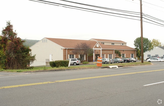
1650 West St, Southington, CT 06489

This Property Is For Sale
NEARBY LISTINGS FOR SALE OR LEASE
Property Detail
1650 West St
SOUT-000167-000000-000009
Hartford
Officebuilding
Connecticut
X
9
09003C0469G
1.58 AC
2025
Southington
2025
Hartford
430604
Hartford-West Hartford-East Hartford, CT
8,400 SF
DEMOGRAPHICS near 1650 West St
1 Mile
3 Mile
5 Mile
2024 Total Population
1,276
41,704
117,850
2029 Population
1,275
41,638
117,593
Pop Growth 2024-2029
(0.08%)
(0.16%)
(0.22%)
Average Age
47
43
42
2024 Total Households
542
17,881
49,074
HH Growth 2024-2029
(0.18%)
(0.18%)
(0.25%)
Median Household Inc
$103,726
$80,191
$82,100
Avg Household Size
2.30
2.30
2.30
2024 Avg HH Vehicles
2.00
2.00
2.00
Median Home Value
$357,142
$264,123
$257,715
Median Year Built
1978
1973
1968
Nearby Places
- Restaurants
- Banks
- Shops
- Fitness
- Groceries
PUBLIC TRANSPORTATION
AIRPORT
Tweed/New Haven
DRIVE
WALK
Distance
Tweed/New Haven
44 min
27.9 mi
Bradley International
DRIVE
WALK
Distance
Bradley International
51 min
34.3 mi
Freight Ports
Port of New Haven
DRIVE
WALK
Distance
Port of New Haven
39 min
25.3 mi
Nearby Properties
Address
Land Use
TOTAL SIZE
Lot Size
Zoning
Address
Land Use
TOTAL SIZE
Lot Size
Zoning
77,001 SF
54.59 AC
IP-1
Address
Land Use
TOTAL SIZE
Lot Size
Zoning
100,304 SF
28.80 AC
IP-1
Address
Land Use
TOTAL SIZE
Lot Size
Zoning
58,473 SF
18.20 AC
IP-1
Address
Land Use
TOTAL SIZE
Lot Size
Zoning
145,719 SF
17.90 AC
R-15
Address
Land Use
TOTAL SIZE
Lot Size
Zoning
395,492 SF
54.09 AC
R-20/2
Address
Land Use
TOTAL SIZE
Lot Size
Zoning
114,375 SF
12.72 AC
IP-1
Address
Land Use
TOTAL SIZE
Lot Size
Zoning
330,400 SF
36.90 AC
IP-1
Address
Land Use
TOTAL SIZE
Lot Size
Zoning
106,970 SF
7.92 AC
R-12
Address
Land Use
TOTAL SIZE
Lot Size
Zoning
128,599 SF
14.75 AC
R-20/2
Address
Land Use
TOTAL SIZE
Lot Size
Zoning
502,440 SF
27.87 AC
I-2
Address
Land Use
TOTAL SIZE
Lot Size
Zoning
17.62 AC
B
Address
Land Use
TOTAL SIZE
Lot Size
Zoning
149,912 SF
13.66 AC
B
Address
Land Use
TOTAL SIZE
Lot Size
Zoning
3,084 SF
14.90 AC
BG
Address
Land Use
TOTAL SIZE
Lot Size
Zoning
133,720 SF
7.34 AC
IP-1
Address
Land Use
TOTAL SIZE
Lot Size
Zoning
130,252 SF
14.82 AC
B
Address
Land Use
TOTAL SIZE
Lot Size
Zoning
137,510 SF
12.95 AC
B
Address
Land Use
TOTAL SIZE
Lot Size
Zoning
16.04 AC
B
Address
Land Use
TOTAL SIZE
Lot Size
Zoning
150,972 SF
9.99 AC
I-1
Address
Land Use
TOTAL SIZE
Lot Size
Zoning
98,463 SF
5.01 AC
I-1
Address
Land Use
TOTAL SIZE
Lot Size
Zoning
109,212 SF
20.15 AC
B
Address
Land Use
TOTAL SIZE
Lot Size
Zoning
121,648 SF
6.96 AC
I-1
Address
Land Use
TOTAL SIZE
Lot Size
Zoning
134,876 SF
19.44 AC
R-12
Address
Land Use
TOTAL SIZE
Lot Size
Zoning
95,940 SF
12 AC
B
Address
Land Use
TOTAL SIZE
Lot Size
Zoning
12.28 AC
R-20/2
Address
Land Use
TOTAL SIZE
Lot Size
Zoning
9.07 AC
B
Address
Land Use
TOTAL SIZE
Lot Size
Zoning
101,250 SF
16.91 AC
B
Address
Land Use
TOTAL SIZE
Lot Size
Zoning
40 AC
I-2
Address
Land Use
TOTAL SIZE
Lot Size
Zoning
101,495 SF
9.74 AC
B
Address
Land Use
TOTAL SIZE
Lot Size
Zoning
67,503 SF
2.53 AC
B
Address
Land Use
TOTAL SIZE
Lot Size
Zoning
97,356 SF
3.40 AC
I
The World's #1 Commercial Real Estate Marketplace
Connect with us
© 2025 CoStar Group
The information above has been obtained from sources believed reliable. While we do not doubt its accuracy we have not verified it and make no guarantee, warranty or representation about it. It is your responsibility to independently confirm its accuracy and completeness. Any projections, opinions, assumptions, or estimates used are for example only and do not represent the current or future performance of the property. The value of this transaction to you depends on tax and other factors which should be evaluated by your tax, financial, and legal advisors. You and your advisors should conduct a careful, independent investigation of the property to determine to your satisfaction the suitability of the property for your needs.