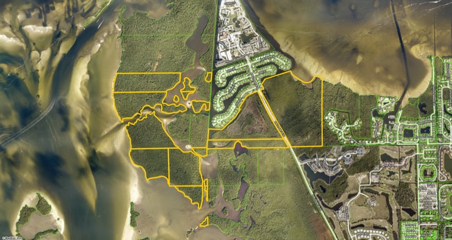
Property Record
Access Undetermined, Fort Myers, FL 33908
NEARBY LISTINGS FOR SALE OR LEASE
Property Detail
Access Undetermined
Cape Coral-Fort Myers, FL
Palm Acres
33-45-23-00-00002.0020
NE 1/4 OF NE 1/4 LESS RR R/W
Wastedisposalsewagetreatmentfacility
Lee
VE
Florida
12071C0395G
3&4
2024
35.87 AC
2025
Fort Myers Outlying
001916
Southwest Florida
DEMOGRAPHICS near Access Undetermined
1 Mile
3 Mile
5 Mile
2024 Total Population
2,526
19,986
77,864
2029 Population
2,993
24,078
93,634
Pop Growth 2024-2029
+ 18.49%
+ 20.47%
+ 20.25%
Average Age
78
63
55
2024 Total Households
1,319
10,308
37,608
HH Growth 2024-2029
+ 18.04%
+ 20.19%
+ 19.94%
Median Household Inc
$60,417
$60,259
$63,117
Avg Household Size
1.50
1.80
2.00
2024 Avg HH Vehicles
1.00
1.00
2.00
Median Home Value
$632,812
$351,742
$343,041
Median Year Built
1984
1989
1990
Nearby Places
Map Layers
Map Styles
 Street
 Aerial
- Restaurants
- Banks
- Shops
- Fitness
- Groceries
PUBLIC TRANSPORTATION
AIRPORT
Southwest Florida International
DRIVE
WALK
Distance
Southwest Florida International
36 min
18.9 mi
Punta Gorda
DRIVE
WALK
Distance
Punta Gorda
65 min
45.1 mi
Freight Ports
Port Manatee
DRIVE
WALK
Distance
Port Manatee
145 min
116.8 mi
SALE & LEASE HISTORY
LISTING DATE
SALE/LEASE

Jul 30, 2021
For Sale
Nearby Properties
Address
Land Use
TOTAL SIZE
Lot Size
Zoning
Address
Land Use
TOTAL SIZE
Lot Size
Zoning
4,442,296 SF
162.17 AC
RM-2
Address
Land Use
TOTAL SIZE
Lot Size
Zoning
334,148 SF
48.67 AC
RM-2
Address
Land Use
TOTAL SIZE
Lot Size
Zoning
224,965 SF
21.13 AC
EC
Address
Land Use
TOTAL SIZE
Lot Size
Zoning
744,621 SF
8.01 AC
C1W
Address
Land Use
TOTAL SIZE
Lot Size
Zoning
235,691 SF
30.01 AC
RM-6
Address
Land Use
TOTAL SIZE
Lot Size
Zoning
106,730 SF
2.36 AC
CPD
Address
Land Use
TOTAL SIZE
Lot Size
Zoning
120,368 SF
3.52 AC
CPD
Address
Land Use
TOTAL SIZE
Lot Size
Zoning
5,654 SF
49.94 AC
MH-2
Address
Land Use
TOTAL SIZE
Lot Size
Zoning
87,275 SF
10.79 AC
CPD
Address
Land Use
TOTAL SIZE
Lot Size
Zoning
85,815 SF
3.48 AC
CT
Address
Land Use
TOTAL SIZE
Lot Size
Zoning
34,689 SF
6.03 AC
CPD
Address
Land Use
TOTAL SIZE
Lot Size
Zoning
80,684 SF
16.28 AC
CT
Address
Land Use
TOTAL SIZE
Lot Size
Zoning
255,761 SF
23.13 AC
CC
Address
Land Use
TOTAL SIZE
Lot Size
Zoning
57,624 SF
4.86 AC
RM-2
Address
Land Use
TOTAL SIZE
Lot Size
Zoning
55,521 SF
3.81 AC
RM-2
Address
Land Use
TOTAL SIZE
Lot Size
Zoning
10,750 SF
4.57 AC
RS-1
Address
Land Use
TOTAL SIZE
Lot Size
Zoning
22,098 SF
0.25 AC
C-1
Address
Land Use
TOTAL SIZE
Lot Size
Zoning
9,483 SF
3.67 AC
RS-1
Address
Land Use
TOTAL SIZE
Lot Size
Zoning
6.84 AC
C-1
Address
Land Use
TOTAL SIZE
Lot Size
Zoning
20,821 SF
5.01 AC
WSHP
Address
Land Use
TOTAL SIZE
Lot Size
Zoning
12,599 SF
1.78 AC
RM-2
Address
Land Use
TOTAL SIZE
Lot Size
Zoning
4.10 AC
RML
Address
Land Use
TOTAL SIZE
Lot Size
Zoning
35,285 SF
1.40 AC
C-1
Address
Land Use
TOTAL SIZE
Lot Size
Zoning
13,951 SF
0.12 AC
C-1
Address
Land Use
TOTAL SIZE
Lot Size
Zoning
12,428 SF
1.27 AC
C-1
Address
Land Use
TOTAL SIZE
Lot Size
Zoning
25,062 SF
2.43 AC
C-1A
Address
Land Use
TOTAL SIZE
Lot Size
Zoning
13,284 SF
6.15 AC
RM-2
Address
Land Use
TOTAL SIZE
Lot Size
Zoning
12,619 SF
1.89 AC
CT
Address
Land Use
TOTAL SIZE
Lot Size
Zoning
7.70 AC
R3W
Address
Land Use
TOTAL SIZE
Lot Size
Zoning
12,331 SF
9.49 AC
AG-2
The World's #1 Commercial Real Estate Marketplace
Connect with us
© 2025 CoStar Group
The information above has been obtained from sources believed reliable. While we do not doubt its accuracy we have not verified it and make no guarantee, warranty or representation about it. It is your responsibility to independently confirm its accuracy and completeness. Any projections, opinions, assumptions, or estimates used are for example only and do not represent the current or future performance of the property. The value of this transaction to you depends on tax and other factors which should be evaluated by your tax, financial, and legal advisors. You and your advisors should conduct a careful, independent investigation of the property to determine to your satisfaction the suitability of the property for your needs.