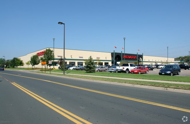
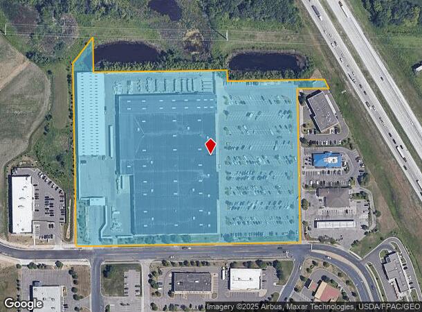
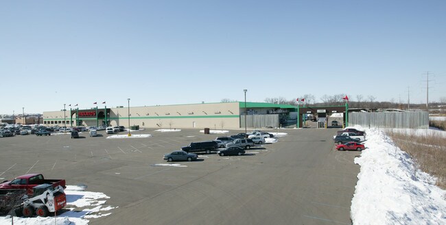
Property Record
16500 96Th Ave N, Maple Grove, MN 55311
NEARBY LISTINGS FOR SALE OR LEASE
-
-
View all Maple Grove listings for sale on LoopNet.com
Property Detail
16500 96Th Ave N
Minneapolis-St. Paul-Bloomington, MN-WI
Maple Commons 8Th Addn
08-119-22-42-0023
LOT 001 BLOCK 001 B MAPLE COMMONS 8TH ADDN IRREGULAR
Commercialnec
Hennepin
X
Minnesota
27053C0063F
1
2024
14.17 AC
2024
Maple Grove
026717
Minneapolis/St Paul
218,543 SF
DEMOGRAPHICS near 16500 96Th Ave N
1 Mile
3 Mile
5 Mile
2024 Total Population
5,954
36,816
87,925
2029 Population
5,863
36,314
86,861
Pop Growth 2024-2029
(1.53%)
(1.36%)
(1.21%)
Average Age
40
40
40
2024 Total Households
2,334
13,461
32,518
HH Growth 2024-2029
(1.76%)
(1.57%)
(1.41%)
Median Household Inc
$94,417
$125,585
$127,040
Avg Household Size
2.50
2.70
2.70
2024 Avg HH Vehicles
2.00
2.00
2.00
Median Home Value
$365,740
$388,172
$390,763
Median Year Built
1997
1993
1994
Nearby Places
Map Layers
Map Styles
 Street
 Aerial
- Restaurants
- Banks
- Shops
- Fitness
- Groceries
PUBLIC TRANSPORTATION
AIRPORT
Minneapolis-St Paul International/Wold-Chamberlain
DRIVE
WALK
Distance
Minneapolis-St Paul International/Wold-Chamberlain
43 min
31.3 mi
Freight Ports
Port Milwaukee
DRIVE
WALK
Distance
Port Milwaukee
394 min
356.4 mi
Nearby Properties
Address
Land Use
TOTAL SIZE
Lot Size
Zoning
Address
Land Use
TOTAL SIZE
Lot Size
Zoning
4.33 AC
Address
Land Use
TOTAL SIZE
Lot Size
Zoning
68.12 AC
Address
Land Use
TOTAL SIZE
Lot Size
Zoning
42.21 AC
Address
Land Use
TOTAL SIZE
Lot Size
Zoning
297,060 SF
19.17 AC
Address
Land Use
TOTAL SIZE
Lot Size
Zoning
25.06 AC
Address
Land Use
TOTAL SIZE
Lot Size
Zoning
Address
Land Use
TOTAL SIZE
Lot Size
Zoning
Address
Land Use
TOTAL SIZE
Lot Size
Zoning
Address
Land Use
TOTAL SIZE
Lot Size
Zoning
228,208 SF
24.92 AC
Address
Land Use
TOTAL SIZE
Lot Size
Zoning
10.44 AC
Address
Land Use
TOTAL SIZE
Lot Size
Zoning
132,200 SF
28.23 AC
Address
Land Use
TOTAL SIZE
Lot Size
Zoning
17.09 AC
Address
Land Use
TOTAL SIZE
Lot Size
Zoning
Address
Land Use
TOTAL SIZE
Lot Size
Zoning
Address
Land Use
TOTAL SIZE
Lot Size
Zoning
20.09 AC
Address
Land Use
TOTAL SIZE
Lot Size
Zoning
Address
Land Use
TOTAL SIZE
Lot Size
Zoning
218,144 SF
3.71 AC
Address
Land Use
TOTAL SIZE
Lot Size
Zoning
11.61 AC
Address
Land Use
TOTAL SIZE
Lot Size
Zoning
10.26 AC
Address
Land Use
TOTAL SIZE
Lot Size
Zoning
219,980 SF
18.09 AC
Address
Land Use
TOTAL SIZE
Lot Size
Zoning
168,961 SF
15.61 AC
Address
Land Use
TOTAL SIZE
Lot Size
Zoning
178,023 SF
14.24 AC
Address
Land Use
TOTAL SIZE
Lot Size
Zoning
144,927 SF
28.23 AC
Address
Land Use
TOTAL SIZE
Lot Size
Zoning
Address
Land Use
TOTAL SIZE
Lot Size
Zoning
Address
Land Use
TOTAL SIZE
Lot Size
Zoning
42,498 SF
2.94 AC
Address
Land Use
TOTAL SIZE
Lot Size
Zoning
2,170 SF
14.43 AC
Address
Land Use
TOTAL SIZE
Lot Size
Zoning
1,848 SF
13.94 AC
Address
Land Use
TOTAL SIZE
Lot Size
Zoning
The World's #1 Commercial Real Estate Marketplace
Connect with us
© 2025 CoStar Group
The information above has been obtained from sources believed reliable. While we do not doubt its accuracy we have not verified it and make no guarantee, warranty or representation about it. It is your responsibility to independently confirm its accuracy and completeness. Any projections, opinions, assumptions, or estimates used are for example only and do not represent the current or future performance of the property. The value of this transaction to you depends on tax and other factors which should be evaluated by your tax, financial, and legal advisors. You and your advisors should conduct a careful, independent investigation of the property to determine to your satisfaction the suitability of the property for your needs.