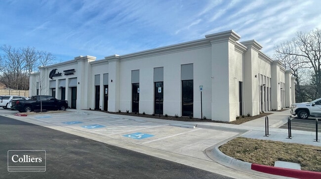
Property Record
1651 E Stearns St, Fayetteville, AR 72703

NEARBY LISTINGS FOR SALE OR LEASE
Property Detail
1651 E Stearns St
765-31256-000
Vantage Office Park
Medicalbuilding
Washington
X
Arkansas
05143C0207G
2
2025
2.05 AC
2025
Greater Fayetteville
010114
Fayetteville/Springdale/Rogers
15,275 SF
Fayetteville-Springdale-Rogers, AR-MO
DEMOGRAPHICS near 1651 E Stearns St
1 Mile
3 Mile
5 Mile
2024 Total Population
5,028
47,401
136,673
2029 Population
5,500
51,677
149,409
Pop Growth 2024-2029
+ 9.39%
+ 9.02%
+ 9.32%
Average Age
41
38
35
2024 Total Households
2,493
19,438
51,453
HH Growth 2024-2029
+ 9.91%
+ 9.22%
+ 9.88%
Median Household Inc
$66,968
$74,162
$60,439
Avg Household Size
1.90
2.40
2.40
2024 Avg HH Vehicles
2.00
2.00
2.00
Median Home Value
$292,215
$273,062
$254,058
Median Year Built
1994
1994
1993
Nearby Places
Map Layers
Map Styles
 Street
 Aerial
- Restaurants
- Banks
- Shops
- Fitness
- Groceries
PUBLIC TRANSPORTATION
AIRPORT
Northwest Arkansas Ntl
DRIVE
WALK
Distance
Northwest Arkansas Ntl
38 min
19.4 mi
Freight Ports
Tulsa Port of Inola
DRIVE
WALK
Distance
Tulsa Port of Inola
107 min
90.8 mi
SALE & LEASE HISTORY
LISTING DATE
SALE/LEASE

Feb 22, 2023
For Lease
Nearby Properties
Address
Land Use
TOTAL SIZE
Lot Size
Zoning
Address
Land Use
TOTAL SIZE
Lot Size
Zoning
167,116 SF
41.39 AC
I1
Address
Land Use
TOTAL SIZE
Lot Size
Zoning
153,698 SF
14.10 AC
C2
Address
Land Use
TOTAL SIZE
Lot Size
Zoning
481,800 SF
40 AC
Address
Land Use
TOTAL SIZE
Lot Size
Zoning
23,707 SF
15.45 AC
R2
Address
Land Use
TOTAL SIZE
Lot Size
Zoning
238,168 SF
Address
Land Use
TOTAL SIZE
Lot Size
Zoning
50,708 SF
1.69 AC
C2
Address
Land Use
TOTAL SIZE
Lot Size
Zoning
232,212 SF
10.31 AC
Address
Land Use
TOTAL SIZE
Lot Size
Zoning
305,272 SF
9.66 AC
R2
Address
Land Use
TOTAL SIZE
Lot Size
Zoning
121,758 SF
20.54 AC
Address
Land Use
TOTAL SIZE
Lot Size
Zoning
567,022 SF
88.88 AC
C2
Address
Land Use
TOTAL SIZE
Lot Size
Zoning
6,798 SF
10.56 AC
Address
Land Use
TOTAL SIZE
Lot Size
Zoning
41,952 SF
19.26 AC
Address
Land Use
TOTAL SIZE
Lot Size
Zoning
19,805 SF
0.35 AC
R0
Address
Land Use
TOTAL SIZE
Lot Size
Zoning
106,961 SF
8.56 AC
Address
Land Use
TOTAL SIZE
Lot Size
Zoning
178,014 SF
6.43 AC
Address
Land Use
TOTAL SIZE
Lot Size
Zoning
261,670 SF
16.72 AC
R2
Address
Land Use
TOTAL SIZE
Lot Size
Zoning
217,873 SF
24.10 AC
C2
Address
Land Use
TOTAL SIZE
Lot Size
Zoning
4,941 SF
10.87 AC
Address
Land Use
TOTAL SIZE
Lot Size
Zoning
64,824 SF
15.82 AC
C2
Address
Land Use
TOTAL SIZE
Lot Size
Zoning
134,342 SF
14.95 AC
Address
Land Use
TOTAL SIZE
Lot Size
Zoning
156,072 SF
12.43 AC
Address
Land Use
TOTAL SIZE
Lot Size
Zoning
56,672 SF
0.53 AC
R0
Address
Land Use
TOTAL SIZE
Lot Size
Zoning
64,659 SF
4.99 AC
R0
Address
Land Use
TOTAL SIZE
Lot Size
Zoning
71,336 SF
6.24 AC
Address
Land Use
TOTAL SIZE
Lot Size
Zoning
20,646 SF
2.45 AC
C2
Address
Land Use
TOTAL SIZE
Lot Size
Zoning
66,120 SF
1.95 AC
Address
Land Use
TOTAL SIZE
Lot Size
Zoning
12,690 SF
1.72 AC
Address
Land Use
TOTAL SIZE
Lot Size
Zoning
72,162 SF
3.31 AC
Address
Land Use
TOTAL SIZE
Lot Size
Zoning
73,436 SF
16.01 AC
I1
Address
Land Use
TOTAL SIZE
Lot Size
Zoning
96,710 SF
The World's #1 Commercial Real Estate Marketplace
Connect with us
© 2026 CoStar Group
The information above has been obtained from sources believed reliable. While we do not doubt its accuracy we have not verified it and make no guarantee, warranty or representation about it. It is your responsibility to independently confirm its accuracy and completeness. Any projections, opinions, assumptions, or estimates used are for example only and do not represent the current or future performance of the property. The value of this transaction to you depends on tax and other factors which should be evaluated by your tax, financial, and legal advisors. You and your advisors should conduct a careful, independent investigation of the property to determine to your satisfaction the suitability of the property for your needs.