Property Record
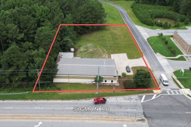
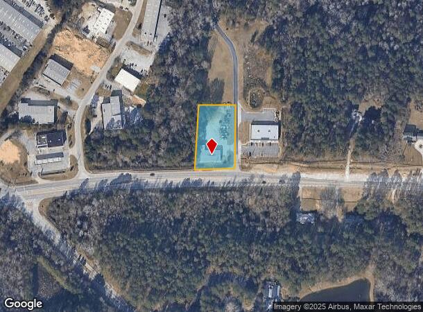
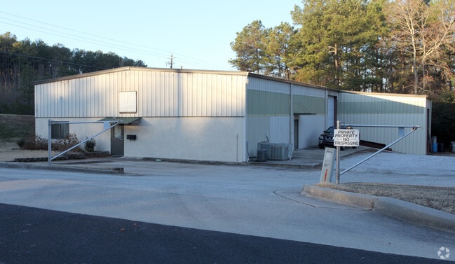
1651 Sigman Rd Nw, Conyers, GA 30012
This Property Is For Sale
NEARBY LISTINGS FOR SALE OR LEASE
Property Detail
1651 Sigman Rd Nw
041-0-01-023J
Commercial
Manufacturinglight
SIGMAN RD - TR1
X
Rockdale
13247C0091D
Georgia
2024
1.23 AC
2025
Rockdale/Newton Cnty
060310
Atlanta
5,675 SF
Atlanta-Sandy Springs-Roswell, GA
DEMOGRAPHICS near 1651 Sigman Rd Nw
1 Mile
3 Mile
5 Mile
2024 Total Population
2,130
32,322
75,571
2029 Population
2,210
33,351
77,703
Pop Growth 2024-2029
+ 3.76%
+ 3.18%
+ 2.82%
Average Age
34
38
38
2024 Total Households
749
11,691
27,652
HH Growth 2024-2029
+ 3.74%
+ 3.12%
+ 2.68%
Median Household Inc
$67,226
$58,751
$60,569
Avg Household Size
2.70
2.60
2.60
2024 Avg HH Vehicles
2.00
2.00
2.00
Median Home Value
$162,499
$188,787
$204,625
Median Year Built
1998
1984
1989
Nearby Places
Map Layers
Map Styles
 Street
 Aerial
- Restaurants
- Banks
- Shops
- Fitness
- Groceries
PUBLIC TRANSPORTATION
AIRPORT
Hartsfield - Jackson Atlanta International
DRIVE
WALK
Distance
Hartsfield - Jackson Atlanta International
37 min
26.0 mi
Nearby Properties
Address
Land Use
TOTAL SIZE
Lot Size
Zoning
Address
Land Use
TOTAL SIZE
Lot Size
Zoning
2,782 SF
29.51 AC
R3/C
Address
Land Use
TOTAL SIZE
Lot Size
Zoning
194,186 SF
18.48 AC
RM100
Address
Land Use
TOTAL SIZE
Lot Size
Zoning
458,448 SF
12.98 AC
OI
Address
Land Use
TOTAL SIZE
Lot Size
Zoning
290,616 SF
23.84 AC
M-1
Address
Land Use
TOTAL SIZE
Lot Size
Zoning
28,024 SF
11.24 AC
R1
Address
Land Use
TOTAL SIZE
Lot Size
Zoning
3,256 SF
22.05 AC
RM
Address
Land Use
TOTAL SIZE
Lot Size
Zoning
55,928 SF
14.63 AC
BN
Address
Land Use
TOTAL SIZE
Lot Size
Zoning
140,058 SF
8.46 AC
C1
Address
Land Use
TOTAL SIZE
Lot Size
Zoning
20,964 SF
25.29 AC
R3/C
Address
Land Use
TOTAL SIZE
Lot Size
Zoning
263,339 SF
24.24 AC
C1
Address
Land Use
TOTAL SIZE
Lot Size
Zoning
165,171 SF
49.79 AC
BG/ID
Address
Land Use
TOTAL SIZE
Lot Size
Zoning
3,066 SF
22.44 AC
R3/R1
Address
Land Use
TOTAL SIZE
Lot Size
Zoning
3,648 SF
1.02 AC
R3/R1
Address
Land Use
TOTAL SIZE
Lot Size
Zoning
173,427 SF
15.18 AC
X
Address
Land Use
TOTAL SIZE
Lot Size
Zoning
417,378 SF
31.95 AC
M1
Address
Land Use
TOTAL SIZE
Lot Size
Zoning
3,888 SF
21.05 AC
RM/C
Address
Land Use
TOTAL SIZE
Lot Size
Zoning
17,800 SF
11.36 AC
RM/C
Address
Land Use
TOTAL SIZE
Lot Size
Zoning
472,620 SF
55.20 AC
RS10
Address
Land Use
TOTAL SIZE
Lot Size
Zoning
152,302 SF
17.91 AC
X
Address
Land Use
TOTAL SIZE
Lot Size
Zoning
76,140 SF
22.20 AC
RM
Address
Land Use
TOTAL SIZE
Lot Size
Zoning
124,591 SF
13.89 AC
C2
Address
Land Use
TOTAL SIZE
Lot Size
Zoning
485,258 SF
23.61 AC
M
Address
Land Use
TOTAL SIZE
Lot Size
Zoning
159,014 SF
3.88 AC
RM
Address
Land Use
TOTAL SIZE
Lot Size
Zoning
28,012 SF
4.04 AC
OI
Address
Land Use
TOTAL SIZE
Lot Size
Zoning
60,470 SF
5.11 AC
C2
Address
Land Use
TOTAL SIZE
Lot Size
Zoning
713,040 SF
67.04 AC
M1
Address
Land Use
TOTAL SIZE
Lot Size
Zoning
65,460 SF
32.41 AC
M1
Address
Land Use
TOTAL SIZE
Lot Size
Zoning
15,419 SF
20.15 AC
PUD
Address
Land Use
TOTAL SIZE
Lot Size
Zoning
196,560 SF
12.06 AC
MI
Address
Land Use
TOTAL SIZE
Lot Size
Zoning
50,400 SF
2.62 AC
M1
The World's #1 Commercial Real Estate Marketplace
Connect with us
© 2026 CoStar Group
The information above has been obtained from sources believed reliable. While we do not doubt its accuracy we have not verified it and make no guarantee, warranty or representation about it. It is your responsibility to independently confirm its accuracy and completeness. Any projections, opinions, assumptions, or estimates used are for example only and do not represent the current or future performance of the property. The value of this transaction to you depends on tax and other factors which should be evaluated by your tax, financial, and legal advisors. You and your advisors should conduct a careful, independent investigation of the property to determine to your satisfaction the suitability of the property for your needs.