Property Record
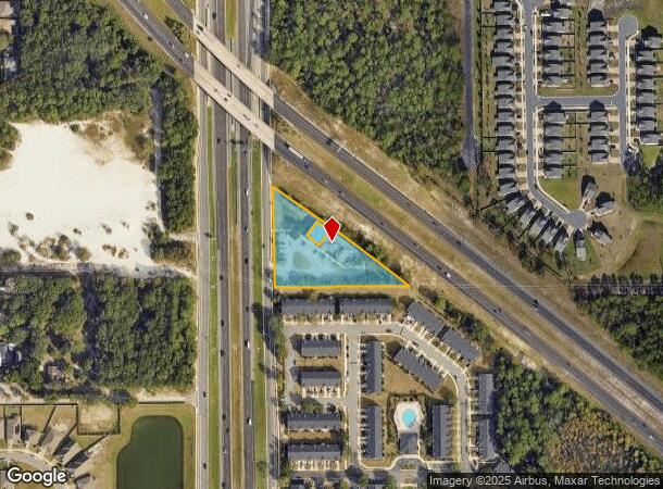
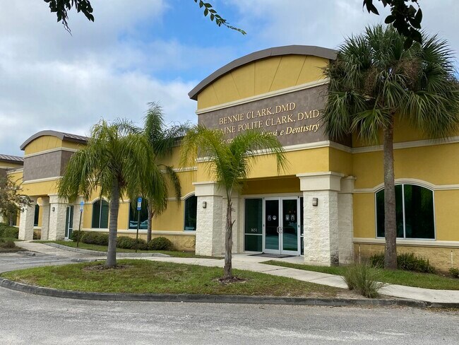
1651 Southside Connector, Jacksonville, FL 32225

This Property Is For Sale
NEARBY LISTINGS FOR SALE OR LEASE
Property Detail
1651 Southside Connector
Jacksonville, FL
Gilmore, S S/D
120618-0100
6-43 12-2S-27E 1.49 GILMORES S/D PT LOT 11 RECD O/R 12763-794 (EX PT RECD O/R 14077-674)
Medicalbuilding
Duval
X
Florida
12031C0381J
11
2025
1.49 AC
2026
Arlington
014604
Jacksonville (Florida)
6,756 SF
DEMOGRAPHICS near 1651 Southside Connector
1 Mile
3 Mile
5 Mile
2024 Total Population
10,159
76,375
175,222
2029 Population
10,625
79,776
182,577
Pop Growth 2024-2029
+ 4.59%
+ 4.45%
+ 4.20%
Average Age
37
37
38
2024 Total Households
4,080
30,026
68,281
HH Growth 2024-2029
+ 4.73%
+ 4.59%
+ 4.32%
Median Household Inc
$55,891
$52,295
$57,180
Avg Household Size
2.40
2.40
2.50
2024 Avg HH Vehicles
2.00
2.00
2.00
Median Home Value
$246,824
$196,251
$232,261
Median Year Built
1996
1978
1982
Nearby Places
Map Layers
Map Styles
 Street
 Aerial
- Restaurants
- Banks
- Shops
- Fitness
- Groceries
PUBLIC TRANSPORTATION
AIRPORT
Jacksonville International
DRIVE
WALK
Distance
Jacksonville International
25 min
15.7 mi
Nearby Properties
Address
Land Use
TOTAL SIZE
Lot Size
Zoning
Address
Land Use
TOTAL SIZE
Lot Size
Zoning
565,202 SF
33.92 AC
RMD-D
Address
Land Use
TOTAL SIZE
Lot Size
Zoning
327,165 SF
25 AC
RMD-D
Address
Land Use
TOTAL SIZE
Lot Size
Zoning
557,032 SF
40.06 AC
PUD
Address
Land Use
TOTAL SIZE
Lot Size
Zoning
430,668 SF
27.20 AC
RMD-D
Address
Land Use
TOTAL SIZE
Lot Size
Zoning
323,318 SF
19.24 AC
PUD
Address
Land Use
TOTAL SIZE
Lot Size
Zoning
321,335 SF
19.83 AC
RMD-D
Address
Land Use
TOTAL SIZE
Lot Size
Zoning
471,372 SF
1,071.38 AC
PUD
Address
Land Use
TOTAL SIZE
Lot Size
Zoning
302,406 SF
20.54 AC
RMD-D
Address
Land Use
TOTAL SIZE
Lot Size
Zoning
300,360 SF
14.44 AC
RMD-C
Address
Land Use
TOTAL SIZE
Lot Size
Zoning
232,520 SF
12.37 AC
RMD-D
Address
Land Use
TOTAL SIZE
Lot Size
Zoning
328,457 SF
23.99 AC
RMD-D
Address
Land Use
TOTAL SIZE
Lot Size
Zoning
210,913 SF
10.32 AC
PUD
Address
Land Use
TOTAL SIZE
Lot Size
Zoning
210,829 SF
11.84 AC
RMD-D
Address
Land Use
TOTAL SIZE
Lot Size
Zoning
184,221 SF
12.05 AC
PUD
Address
Land Use
TOTAL SIZE
Lot Size
Zoning
154,382 SF
8.67 AC
RMD-D
Address
Land Use
TOTAL SIZE
Lot Size
Zoning
166,588 SF
10.40 AC
RMD-D
Address
Land Use
TOTAL SIZE
Lot Size
Zoning
164,330 SF
9.04 AC
PUD
Address
Land Use
TOTAL SIZE
Lot Size
Zoning
267,103 SF
17.31 AC
RMD-C
Address
Land Use
TOTAL SIZE
Lot Size
Zoning
125,088 SF
6.62 AC
RMD-D
Address
Land Use
TOTAL SIZE
Lot Size
Zoning
245,531 SF
17.37 AC
CCG-1
Address
Land Use
TOTAL SIZE
Lot Size
Zoning
80,308 SF
12.07 AC
PUD
Address
Land Use
TOTAL SIZE
Lot Size
Zoning
229,298 SF
11.74 AC
RMD-D
Address
Land Use
TOTAL SIZE
Lot Size
Zoning
122,854 SF
12.25 AC
PUD
Address
Land Use
TOTAL SIZE
Lot Size
Zoning
252,229 SF
10.74 AC
RMD-D
Address
Land Use
TOTAL SIZE
Lot Size
Zoning
180,180 SF
11.06 AC
CRO
Address
Land Use
TOTAL SIZE
Lot Size
Zoning
116,814 SF
11.77 AC
RMD-D
Address
Land Use
TOTAL SIZE
Lot Size
Zoning
180,528 SF
10.57 AC
RMD-D
Address
Land Use
TOTAL SIZE
Lot Size
Zoning
98,760 SF
5.66 AC
RMD-D
Address
Land Use
TOTAL SIZE
Lot Size
Zoning
156,969 SF
15.27 AC
RMD-D
Address
Land Use
TOTAL SIZE
Lot Size
Zoning
382,055 SF
28.81 AC
CCG-1
The World's #1 Commercial Real Estate Marketplace
Connect with us
© 2026 CoStar Group
The information above has been obtained from sources believed reliable. While we do not doubt its accuracy we have not verified it and make no guarantee, warranty or representation about it. It is your responsibility to independently confirm its accuracy and completeness. Any projections, opinions, assumptions, or estimates used are for example only and do not represent the current or future performance of the property. The value of this transaction to you depends on tax and other factors which should be evaluated by your tax, financial, and legal advisors. You and your advisors should conduct a careful, independent investigation of the property to determine to your satisfaction the suitability of the property for your needs.