Property Record
1652 Sw Eagerton Dr, Arcadia, FL 34266

NEARBY LISTINGS FOR SALE OR LEASE
Property Detail
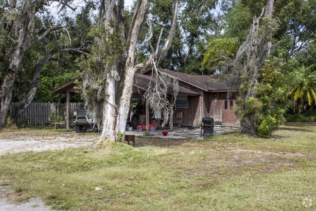
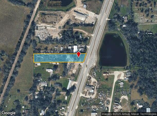
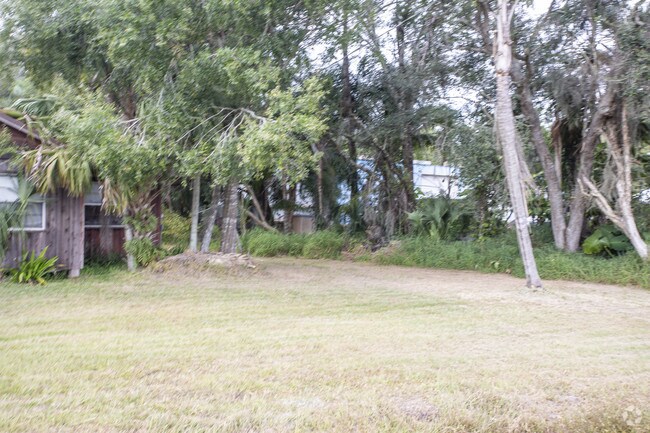
1652 Sw Eagerton Dr
12-38-24-0000-0480-0000
To W Bdry Sd
Multifamilydwelling
BEG SW COR OF SE1/4 OF NW1/4 TH N ALG LAND LI 100 FT FOR POB TH E 667 FT TO W R/W STATE RD TH NELY ALG R/W 121.3 FT TH W 707.3 FT TO W BDRY SD FORTY TH S ALG SD W BDRY 115 FT TO POB BEING IN SE1/4 OF NW1/4 OR 83/236 INST:201314005699 INST:20151400115
X
DeSoto
12027C0178C
Florida
2024
1.80 AC
2024
Florida Central South Area
010302
Other Market Areas
1,872 SF
Arcadia, FL
DEMOGRAPHICS near 1652 Sw Eagerton Dr
1 Mile
3 Mile
5 Mile
2024 Total Population
2,113
17,208
24,199
2029 Population
2,359
19,066
26,703
Pop Growth 2024-2029
+ 11.64%
+ 10.80%
+ 10.35%
Average Age
36
38
40
2024 Total Households
685
5,887
8,318
HH Growth 2024-2029
+ 12.70%
+ 11.70%
+ 11.32%
Median Household Inc
$39,374
$33,145
$34,622
Avg Household Size
3.10
2.80
2.70
2024 Avg HH Vehicles
2.00
2.00
2.00
Median Home Value
$94,257
$121,127
$117,203
Median Year Built
1981
1980
1984
Nearby Places
Map Layers
Map Styles
 Street
 Aerial
- Restaurants
- Banks
- Shops
- Fitness
- Groceries
PUBLIC TRANSPORTATION
AIRPORT
Punta Gorda
DRIVE
WALK
Distance
Punta Gorda
33 min
23.2 mi
Freight Ports
Port Manatee
DRIVE
WALK
Distance
Port Manatee
83 min
60.2 mi
Nearby Properties
Address
Land Use
TOTAL SIZE
Lot Size
Zoning
Address
Land Use
TOTAL SIZE
Lot Size
Zoning
67,387 SF
46.10 AC
PUD
Address
Land Use
TOTAL SIZE
Lot Size
Zoning
106,179 SF
12.48 AC
RPB
Address
Land Use
TOTAL SIZE
Lot Size
Zoning
128,748 SF
21.47 AC
CG
Address
Land Use
TOTAL SIZE
Lot Size
Zoning
57,048 SF
20.25 AC
PUD
Address
Land Use
TOTAL SIZE
Lot Size
Zoning
7,911 SF
30 AC
TTRVC
Address
Land Use
TOTAL SIZE
Lot Size
Zoning
67,970 SF
8.24 AC
CG
Address
Land Use
TOTAL SIZE
Lot Size
Zoning
121,889 SF
9 AC
B-3
Address
Land Use
TOTAL SIZE
Lot Size
Zoning
67,407 SF
4.82 AC
R-1B
Address
Land Use
TOTAL SIZE
Lot Size
Zoning
83,273 SF
13.94 AC
ROI
Address
Land Use
TOTAL SIZE
Lot Size
Zoning
25,798 SF
5 AC
B-1A
Address
Land Use
TOTAL SIZE
Lot Size
Zoning
39,416 SF
2.29 AC
CG
Address
Land Use
TOTAL SIZE
Lot Size
Zoning
80,103 SF
11 AC
R-1B
Address
Land Use
TOTAL SIZE
Lot Size
Zoning
53,740 SF
2.29 AC
R-1B
Address
Land Use
TOTAL SIZE
Lot Size
Zoning
45,985 SF
1.30 AC
B-2
Address
Land Use
TOTAL SIZE
Lot Size
Zoning
40,614 SF
4.33 AC
R-3
Address
Land Use
TOTAL SIZE
Lot Size
Zoning
41,004 SF
4.67 AC
R-3
Address
Land Use
TOTAL SIZE
Lot Size
Zoning
27,816 SF
3.67 AC
RMF-8
Address
Land Use
TOTAL SIZE
Lot Size
Zoning
48,488 SF
3.24 AC
B-2
Address
Land Use
TOTAL SIZE
Lot Size
Zoning
97,755 SF
9.20 AC
PUD
Address
Land Use
TOTAL SIZE
Lot Size
Zoning
21,108 SF
3.36 AC
A-5
Address
Land Use
TOTAL SIZE
Lot Size
Zoning
20,008 SF
4.69 AC
A-5
Address
Land Use
TOTAL SIZE
Lot Size
Zoning
32,256 SF
3.13 AC
R-4
Address
Land Use
TOTAL SIZE
Lot Size
Zoning
40,470 SF
3.99 AC
CG
Address
Land Use
TOTAL SIZE
Lot Size
Zoning
13,509 SF
1.93 AC
CG
Address
Land Use
TOTAL SIZE
Lot Size
Zoning
13,700 SF
2.39 AC
CG
Address
Land Use
TOTAL SIZE
Lot Size
Zoning
26,360 SF
1.80 AC
P-1
Address
Land Use
TOTAL SIZE
Lot Size
Zoning
59,064 SF
7 AC
RSF-3
Address
Land Use
TOTAL SIZE
Lot Size
Zoning
34,600 SF
4.85 AC
RPB
Address
Land Use
TOTAL SIZE
Lot Size
Zoning
66,888 SF
11.95 AC
RMF-12
Address
Land Use
TOTAL SIZE
Lot Size
Zoning
25,790 SF
2.47 AC
R-1B
The World's #1 Commercial Real Estate Marketplace
Connect with us
© 2025 CoStar Group
The information above has been obtained from sources believed reliable. While we do not doubt its accuracy we have not verified it and make no guarantee, warranty or representation about it. It is your responsibility to independently confirm its accuracy and completeness. Any projections, opinions, assumptions, or estimates used are for example only and do not represent the current or future performance of the property. The value of this transaction to you depends on tax and other factors which should be evaluated by your tax, financial, and legal advisors. You and your advisors should conduct a careful, independent investigation of the property to determine to your satisfaction the suitability of the property for your needs.