Property Record
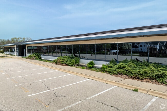
1657 Shermer Rd, Northbrook, IL 60062

This Property Is For Sale
NEARBY LISTINGS FOR SALE OR LEASE
Property Detail
1657 Shermer Rd
04-15-100-047-0000
First Addition To Northbrook
Taxexempt
Cook
X
Illinois
17031C0227J
8.89 AC
2021
North Cook
2024
Chicago
801702
Chicago-Naperville-Elgin, IL-IN-WI
DEMOGRAPHICS near 1657 Shermer Rd
1 Mile
3 Mile
5 Mile
2024 Total Population
10,321
69,930
213,608
2029 Population
10,087
68,474
208,960
Pop Growth 2024-2029
(2.27%)
(2.08%)
(2.18%)
Average Age
42
46
43
2024 Total Households
3,616
26,741
80,036
HH Growth 2024-2029
(2.54%)
(2.36%)
(2.39%)
Median Household Inc
$174,336
$132,018
$115,902
Avg Household Size
2.70
2.50
2.60
2024 Avg HH Vehicles
2.00
2.00
2.00
Median Home Value
$651,333
$617,324
$546,563
Median Year Built
1966
1977
1971
Nearby Places
Map Layers
Map Styles
 Street
 Aerial
- Restaurants
- Banks
- Shops
- Fitness
- Groceries
PUBLIC TRANSPORTATION
COMMUTER RAIL
Northbrook Station (Milwaukee District North Line - Northeast Illinois Regional Commuter Railroad (Metra))
DRIVE
WALK
Distance
Northbrook Station (Milwaukee District North Line - Northeast Illinois Regional Commuter Railroad (Metra))
2 min
10 min
0.5 mi
North Glenview Station (Milwaukee District North Line - Northeast Illinois Regional Commuter Railroad (Metra))
DRIVE
WALK
Distance
North Glenview Station (Milwaukee District North Line - Northeast Illinois Regional Commuter Railroad (Metra))
6 min
2.7 mi
AIRPORT
Chicago O'Hare International
DRIVE
WALK
Distance
Chicago O'Hare International
21 min
14.0 mi
Chicago Midway International
DRIVE
WALK
Distance
Chicago Midway International
47 min
29.7 mi
Freight Ports
Port Milwaukee
DRIVE
WALK
Distance
Port Milwaukee
78 min
66.7 mi
Nearby Properties
Address
Land Use
TOTAL SIZE
Lot Size
Zoning
Address
Land Use
TOTAL SIZE
Lot Size
Zoning
Address
Land Use
TOTAL SIZE
Lot Size
Zoning
815,308 SF
12.95 AC
Address
Land Use
TOTAL SIZE
Lot Size
Zoning
708,522 SF
17.11 AC
Address
Land Use
TOTAL SIZE
Lot Size
Zoning
530,208 SF
Address
Land Use
TOTAL SIZE
Lot Size
Zoning
8.04 AC
Address
Land Use
TOTAL SIZE
Lot Size
Zoning
629,447 SF
3.96 AC
Address
Land Use
TOTAL SIZE
Lot Size
Zoning
443,916 SF
5.61 AC
Address
Land Use
TOTAL SIZE
Lot Size
Zoning
679,109 SF
24.46 AC
Address
Land Use
TOTAL SIZE
Lot Size
Zoning
419,812 SF
13.88 AC
Address
Land Use
TOTAL SIZE
Lot Size
Zoning
32.61 AC
Address
Land Use
TOTAL SIZE
Lot Size
Zoning
534,816 SF
6.98 AC
Address
Land Use
TOTAL SIZE
Lot Size
Zoning
579,162 SF
6.41 AC
Address
Land Use
TOTAL SIZE
Lot Size
Zoning
14.11 AC
Address
Land Use
TOTAL SIZE
Lot Size
Zoning
186,646 SF
26.69 AC
Address
Land Use
TOTAL SIZE
Lot Size
Zoning
349,846 SF
5.11 AC
Address
Land Use
TOTAL SIZE
Lot Size
Zoning
333,202 SF
13.88 AC
Address
Land Use
TOTAL SIZE
Lot Size
Zoning
167,843 SF
12.55 AC
Address
Land Use
TOTAL SIZE
Lot Size
Zoning
6.32 AC
Address
Land Use
TOTAL SIZE
Lot Size
Zoning
215,633 SF
9.78 AC
Address
Land Use
TOTAL SIZE
Lot Size
Zoning
76,014 SF
2.81 AC
Address
Land Use
TOTAL SIZE
Lot Size
Zoning
142,300 SF
13.16 AC
Address
Land Use
TOTAL SIZE
Lot Size
Zoning
193,804 SF
7.98 AC
Address
Land Use
TOTAL SIZE
Lot Size
Zoning
247,655 SF
12.19 AC
Address
Land Use
TOTAL SIZE
Lot Size
Zoning
191,402 SF
6.92 AC
Address
Land Use
TOTAL SIZE
Lot Size
Zoning
183,952 SF
4.33 AC
Address
Land Use
TOTAL SIZE
Lot Size
Zoning
149,716 SF
6.02 AC
Address
Land Use
TOTAL SIZE
Lot Size
Zoning
58,280 SF
3.46 AC
Address
Land Use
TOTAL SIZE
Lot Size
Zoning
89,080 SF
6.81 AC
Address
Land Use
TOTAL SIZE
Lot Size
Zoning
230,886 SF
9.30 AC
The World's #1 Commercial Real Estate Marketplace
Connect with us
© 2025 CoStar Group
The information above has been obtained from sources believed reliable. While we do not doubt its accuracy we have not verified it and make no guarantee, warranty or representation about it. It is your responsibility to independently confirm its accuracy and completeness. Any projections, opinions, assumptions, or estimates used are for example only and do not represent the current or future performance of the property. The value of this transaction to you depends on tax and other factors which should be evaluated by your tax, financial, and legal advisors. You and your advisors should conduct a careful, independent investigation of the property to determine to your satisfaction the suitability of the property for your needs.