Property Record
165973 S Highway 81, Marlow, OK 73055
NEARBY LISTINGS FOR SALE OR LEASE
-
-
View all Marlow listings for sale on LoopNet.com
Property Detail
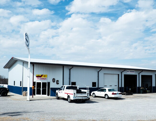
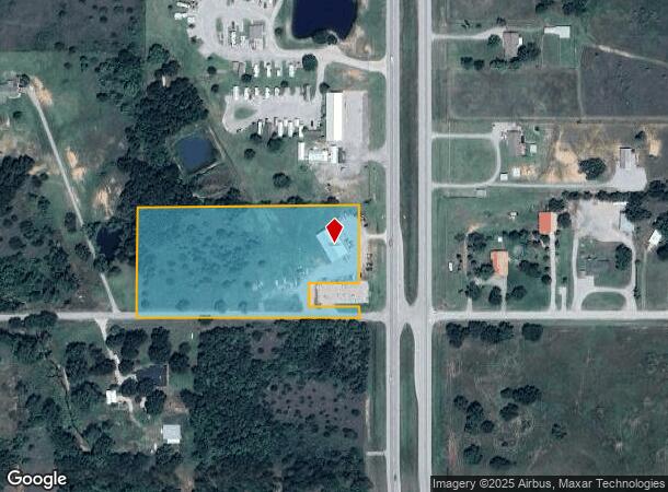
165973 S Highway 81
Duncan, OK
T2n-R7w
0000-30-02N-07W-4-014-00
30-2N-7W TR BEG 160.0S895746W SE/C SE N000804.44W329.93 S895800.34W660 S000804.44E329.976 N895746E660 TO POB LESS TR BEG 160W
Warehouse
Stephens
X
Oklahoma
40137C0225F
7w
2024
4.76 AC
2025
Oklahoma West Area
0009011153
Other Market Areas
4,513 SF
DEMOGRAPHICS near 165973 S Highway 81
1 Mile
3 Mile
5 Mile
2024 Total Population
308
4,924
10,092
2029 Population
317
5,132
10,475
Pop Growth 2024-2029
+ 2.92%
+ 4.22%
+ 3.80%
Average Age
43
42
43
2024 Total Households
120
1,937
4,091
HH Growth 2024-2029
+ 2.50%
+ 4.18%
+ 3.67%
Median Household Inc
$57,999
$49,961
$59,673
Avg Household Size
2.50
2.50
2.40
2024 Avg HH Vehicles
2.00
2.00
2.00
Median Home Value
$181,666
$156,985
$166,457
Median Year Built
1981
1977
1978
Nearby Places
Map Layers
Map Styles
 Street
 Aerial
- Restaurants
- Banks
- Shops
- Fitness
- Groceries
PUBLIC TRANSPORTATION
AIRPORT
Lawton-Fort Sill Regional
DRIVE
WALK
Distance
Lawton-Fort Sill Regional
39 min
29.2 mi
Freight Ports
Tulsa Port Of Catoosa
DRIVE
WALK
Distance
Tulsa Port Of Catoosa
214 min
196.1 mi
SALE & LEASE HISTORY
LISTING DATE
SALE/LEASE

Nov 30, 2021
For Sale
Jul 18, 2018
For Sale
Apr 19, 2019
For Sale
Nearby Properties
Address
Land Use
TOTAL SIZE
Lot Size
Zoning
Address
Land Use
TOTAL SIZE
Lot Size
Zoning
34,004 SF
1.44 AC
R1
Address
Land Use
TOTAL SIZE
Lot Size
Zoning
7,685 SF
35 AC
Address
Land Use
TOTAL SIZE
Lot Size
Zoning
1,584 SF
2.82 AC
Address
Land Use
TOTAL SIZE
Lot Size
Zoning
154 SF
14 AC
Address
Land Use
TOTAL SIZE
Lot Size
Zoning
5,037 SF
13.41 AC
Address
Land Use
TOTAL SIZE
Lot Size
Zoning
2,989 SF
13.49 AC
C2
Address
Land Use
TOTAL SIZE
Lot Size
Zoning
12,500 SF
1.22 AC
Address
Land Use
TOTAL SIZE
Lot Size
Zoning
14,000 SF
0.34 AC
R1
Address
Land Use
TOTAL SIZE
Lot Size
Zoning
6,610 SF
0.66 AC
C2
Address
Land Use
TOTAL SIZE
Lot Size
Zoning
160 SF
6.70 AC
C2
Address
Land Use
TOTAL SIZE
Lot Size
Zoning
11,310 SF
2.66 AC
R1
Address
Land Use
TOTAL SIZE
Lot Size
Zoning
11,008 SF
0.57 AC
R1
Address
Land Use
TOTAL SIZE
Lot Size
Zoning
532 SF
40.47 AC
C1
Address
Land Use
TOTAL SIZE
Lot Size
Zoning
1,440 SF
25 AC
Address
Land Use
TOTAL SIZE
Lot Size
Zoning
8,700 SF
0.63 AC
C2
Address
Land Use
TOTAL SIZE
Lot Size
Zoning
1,532 SF
0.67 AC
R1
Address
Land Use
TOTAL SIZE
Lot Size
Zoning
3,375 SF
0.85 AC
C2
Address
Land Use
TOTAL SIZE
Lot Size
Zoning
10,679 SF
0.63 AC
C1
Address
Land Use
TOTAL SIZE
Lot Size
Zoning
6,250 SF
5 AC
C1
Address
Land Use
TOTAL SIZE
Lot Size
Zoning
10,500 SF
1.91 AC
C2
Address
Land Use
TOTAL SIZE
Lot Size
Zoning
4,560 SF
7.06 AC
C1
Address
Land Use
TOTAL SIZE
Lot Size
Zoning
1,200 SF
20 AC
Address
Land Use
TOTAL SIZE
Lot Size
Zoning
11,768 SF
1.38 AC
C2
Address
Land Use
TOTAL SIZE
Lot Size
Zoning
7,380 SF
8.61 AC
R1
Address
Land Use
TOTAL SIZE
Lot Size
Zoning
3,708 SF
3.79 AC
R1
Address
Land Use
TOTAL SIZE
Lot Size
Zoning
3,000 SF
5.33 AC
R1
Address
Land Use
TOTAL SIZE
Lot Size
Zoning
18,180 SF
4.59 AC
C1
Address
Land Use
TOTAL SIZE
Lot Size
Zoning
6,955 SF
0.34 AC
R1
Address
Land Use
TOTAL SIZE
Lot Size
Zoning
3,600 SF
1.30 AC
R1
The World's #1 Commercial Real Estate Marketplace
Connect with us
© 2025 CoStar Group
The information above has been obtained from sources believed reliable. While we do not doubt its accuracy we have not verified it and make no guarantee, warranty or representation about it. It is your responsibility to independently confirm its accuracy and completeness. Any projections, opinions, assumptions, or estimates used are for example only and do not represent the current or future performance of the property. The value of this transaction to you depends on tax and other factors which should be evaluated by your tax, financial, and legal advisors. You and your advisors should conduct a careful, independent investigation of the property to determine to your satisfaction the suitability of the property for your needs.