Property Record
166 Pam Ct, Macon, GA 31206

Save to a Folder
{{folder.Name}}
{{folder.ListingIds.length}} Properties
{{folder.ListingIds.length}} Property
Create a New Folder
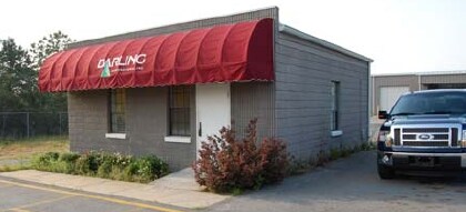
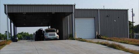
Property Detail
166 Pam Ct
Q104-0011
MEAD ROAD DEVELOPMENT
Autorepair
BIBB
M-2
Georgia
B and X Area of moderate flood hazard, usually the area between the limits of the 100-year and 500-year floods.
3
2025
2.80 AC
2025
Macon
012600
Atlanta
2,346 SF
Macon-Bibb County, GA
NEARBY LISTINGS FOR SALE OR LEASE
DEMOGRAPHICS near 166 Pam Ct
1 mile
3 mile
5 mile
2025 Total Population
1,651
19,657
67,710
2030 Population
1,721
20,010
69,149
Pop Growth 2025-2030
+ 4.24%
+ 1.80%
+ 2.13%
Average Age
38
36
37
2025 Total Households
576
7,015
26,527
HH Growth 2025-2030
+ 4.51%
+ 2.30%
+ 2.28%
Median Household Inc
$23,628
$29,082
$34,037
Avg Household Size
2.50
2.40
2.40
2025 Avg HH Vehicles
1.00
1.00
1.00
Median Home Value
$247,222
$94,378
$135,283
Median Year Built
1955
1961
1964
Nearby Places
Map Layers
Map Styles
 Street
 Aerial
Layers
 Traffic
 Biking
Places
Listings with unknown addresses are not visible on the map
- Restaurants
- Banks
- Shops
- Fitness
- Groceries
SALE & LEASE HISTORY
LISTING DATE
SALE/LEASE

May 03, 2019
For Lease
Jan 28, 2019
For Sale
Nearby Properties
Address
Land Use
TOTAL SIZE
Lot Size
Zoning
Address
Land Use
TOTAL SIZE
Lot Size
Zoning
616,986 SF
130.58 AC
M-2
Address
Land Use
TOTAL SIZE
Lot Size
Zoning
983,943 SF
136.41 AC
M-2
Address
Land Use
TOTAL SIZE
Lot Size
Zoning
181,396 SF
44.77 AC
R-1A
Address
Land Use
TOTAL SIZE
Lot Size
Zoning
12,817 SF
357.49 AC
M-2
Address
Land Use
TOTAL SIZE
Lot Size
Zoning
18,128 SF
95 AC
M-2
Address
Land Use
TOTAL SIZE
Lot Size
Zoning
98,928 SF
12.32 AC
R-3
Address
Land Use
TOTAL SIZE
Lot Size
Zoning
110,153 SF
22 AC
R-2
Address
Land Use
TOTAL SIZE
Lot Size
Zoning
46,288 SF
1.80 AC
PDE
Address
Land Use
TOTAL SIZE
Lot Size
Zoning
33,248 SF
10.18 AC
R-3
Address
Land Use
TOTAL SIZE
Lot Size
Zoning
30,096 SF
6.63 AC
PDR
Address
Land Use
TOTAL SIZE
Lot Size
Zoning
44,323 SF
2.76 AC
PDE
Address
Land Use
TOTAL SIZE
Lot Size
Zoning
32,300 SF
24.40 AC
R-2
Address
Land Use
TOTAL SIZE
Lot Size
Zoning
174,764 SF
Address
Land Use
TOTAL SIZE
Lot Size
Zoning
100,192 SF
30.29 AC
C-2
Address
Land Use
TOTAL SIZE
Lot Size
Zoning
3,196 SF
12.94 AC
R-3
Address
Land Use
TOTAL SIZE
Lot Size
Zoning
280,569 SF
Address
Land Use
TOTAL SIZE
Lot Size
Zoning
87,002 SF
3.73 AC
PDR/R-3
Address
Land Use
TOTAL SIZE
Lot Size
Zoning
4,966 SF
6.05 AC
PDR
Address
Land Use
TOTAL SIZE
Lot Size
Zoning
6,120 SF
4.95 AC
C-2
Address
Land Use
TOTAL SIZE
Lot Size
Zoning
3,500 SF
6.07 AC
R-3
Address
Land Use
TOTAL SIZE
Lot Size
Zoning
201,615 SF
20.36 AC
M-1
Address
Land Use
TOTAL SIZE
Lot Size
Zoning
64,723 SF
6.12 AC
R-1
Address
Land Use
TOTAL SIZE
Lot Size
Zoning
214,303 SF
5.91 AC
M-2
Address
Land Use
TOTAL SIZE
Lot Size
Zoning
76,779 SF
7.08 AC
C-2
Address
Land Use
TOTAL SIZE
Lot Size
Zoning
41,949 SF
10 AC
R-1
Address
Land Use
TOTAL SIZE
Lot Size
Zoning
4,896 SF
19.77 AC
M-2
Address
Land Use
TOTAL SIZE
Lot Size
Zoning
6,480 SF
102.17 AC
M-2
Address
Land Use
TOTAL SIZE
Lot Size
Zoning
121,868 SF
12.31 AC
C-2
Address
Land Use
TOTAL SIZE
Lot Size
Zoning
43,659 SF
21.29 AC
C-2
Address
Land Use
TOTAL SIZE
Lot Size
Zoning
85,840 SF
6.99 AC
The World's #1 Commercial Real Estate Marketplace
Connect with us
© 2026 CoStar Group
The information above has been obtained from sources believed reliable. While we do not doubt its accuracy we have not verified it and make no guarantee, warranty or representation about it. It is your responsibility to independently confirm its accuracy and completeness. Any projections, opinions, assumptions, or estimates used are for example only and do not represent the current or future performance of the property. The value of this transaction to you depends on tax and other factors which should be evaluated by your tax, financial, and legal advisors. You and your advisors should conduct a careful, independent investigation of the property to determine to your satisfaction the suitability of the property for your needs.