Property Record
166 Summit St, Mohawk, NY 13407
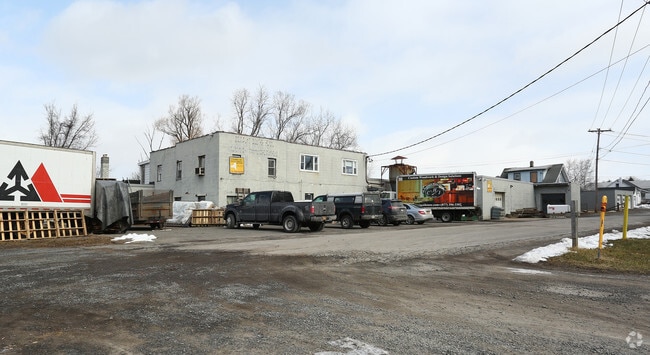

Property Detail
166 Summit St
Utica-Rome, NY
SUMMIT AVE N COMM APT L10 205X120.5
212889-120-042-0001-008-000-0000
Herkimer
Manufacturinglight
New York
01 - NOT Z
8.000
2025
0.52 AC
2025
Herkimer County
010502
Utica/Rome
16,004 SF
NEARBY LISTINGS FOR SALE OR LEASE
DEMOGRAPHICS near 166 Summit St
1 mile
3 mile
5 mile
2025 Total Population
3,933
13,893
25,223
2030 Population
3,884
13,758
24,900
Pop Growth 2025-2030
(1.25%)
(0.97%)
(1.28%)
Average Age
40
42
42
2025 Total Households
1,791
5,909
10,643
HH Growth 2025-2030
(1.17%)
(1.07%)
(1.37%)
Median Household Inc
$40,548
$58,759
$64,169
Avg Household Size
2.00
2.10
2.20
2025 Avg HH Vehicles
1.00
2.00
2.00
Median Home Value
$94,970
$125,865
$130,420
Median Year Built
1947
1948
1948
Nearby Places
Map Layers
Map Styles
 Street
 Aerial
Layers
 Traffic
 Biking
Places
Listings with unknown addresses are not visible on the map
- Restaurants
- Banks
- Shops
- Fitness
- Groceries
SALE & LEASE HISTORY
LISTING DATE
SALE/LEASE

Nov 06, 2019
For Sale
Mar 30, 2023
For Lease
Mar 30, 2023
For Sale
Mar 21, 2025
For Sale
Feb 01, 2018
For Sale
Nearby Properties
Address
Land Use
TOTAL SIZE
Lot Size
Zoning
Address
Land Use
TOTAL SIZE
Lot Size
Zoning
93,840 SF
2.20 AC
C3
Address
Land Use
TOTAL SIZE
Lot Size
Zoning
151,309 SF
11.50 AC
R3
Address
Land Use
TOTAL SIZE
Lot Size
Zoning
90,636 SF
2.10 AC
C
Address
Land Use
TOTAL SIZE
Lot Size
Zoning
1 AC
GB
Address
Land Use
TOTAL SIZE
Lot Size
Zoning
208,087 SF
18.72 AC
C2
Address
Land Use
TOTAL SIZE
Lot Size
Zoning
122,210 SF
12.50 AC
I1
Address
Land Use
TOTAL SIZE
Lot Size
Zoning
221.80 AC
A
Address
Land Use
TOTAL SIZE
Lot Size
Zoning
206,440 SF
6.60 AC
R
Address
Land Use
TOTAL SIZE
Lot Size
Zoning
139,863 SF
16.90 AC
Address
Land Use
TOTAL SIZE
Lot Size
Zoning
19,680 SF
1.10 AC
R3
Address
Land Use
TOTAL SIZE
Lot Size
Zoning
267,566 SF
22.40 AC
M1
Address
Land Use
TOTAL SIZE
Lot Size
Zoning
81,816 SF
1.50 AC
R3
Address
Land Use
TOTAL SIZE
Lot Size
Zoning
77,493 SF
9.70 AC
R3
Address
Land Use
TOTAL SIZE
Lot Size
Zoning
82,165 SF
4.70 AC
R
Address
Land Use
TOTAL SIZE
Lot Size
Zoning
56,530 SF
10.50 AC
C1
Address
Land Use
TOTAL SIZE
Lot Size
Zoning
98,801 SF
59 AC
R2
Address
Land Use
TOTAL SIZE
Lot Size
Zoning
26,799 SF
1.50 AC
R3
Address
Land Use
TOTAL SIZE
Lot Size
Zoning
24,960 SF
3.10 AC
PS
Address
Land Use
TOTAL SIZE
Lot Size
Zoning
89,378 SF
0.30 AC
C
Address
Land Use
TOTAL SIZE
Lot Size
Zoning
1,503 SF
3.49 AC
C
Address
Land Use
TOTAL SIZE
Lot Size
Zoning
2,662 SF
3.90 AC
C
Address
Land Use
TOTAL SIZE
Lot Size
Zoning
80,832 SF
1.91 AC
B1
Address
Land Use
TOTAL SIZE
Lot Size
Zoning
48,893 SF
1.50 AC
C
Address
Land Use
TOTAL SIZE
Lot Size
Zoning
255,260 SF
45.40 AC
I1
Address
Land Use
TOTAL SIZE
Lot Size
Zoning
14,841 SF
1.67 AC
C2
Address
Land Use
TOTAL SIZE
Lot Size
Zoning
21,104 SF
0.80 AC
R2
Address
Land Use
TOTAL SIZE
Lot Size
Zoning
18,050 SF
0.56 AC
C3
Address
Land Use
TOTAL SIZE
Lot Size
Zoning
22,152 SF
3.10 AC
B2
Address
Land Use
TOTAL SIZE
Lot Size
Zoning
159,334 SF
8.20 AC
Address
Land Use
TOTAL SIZE
Lot Size
Zoning
12,808 SF
5.10 AC
The World's #1 Commercial Real Estate Marketplace
Connect with us
© 2026 CoStar Group
The information above has been obtained from sources believed reliable. While we do not doubt its accuracy we have not verified it and make no guarantee, warranty or representation about it. It is your responsibility to independently confirm its accuracy and completeness. Any projections, opinions, assumptions, or estimates used are for example only and do not represent the current or future performance of the property. The value of this transaction to you depends on tax and other factors which should be evaluated by your tax, financial, and legal advisors. You and your advisors should conduct a careful, independent investigation of the property to determine to your satisfaction the suitability of the property for your needs.