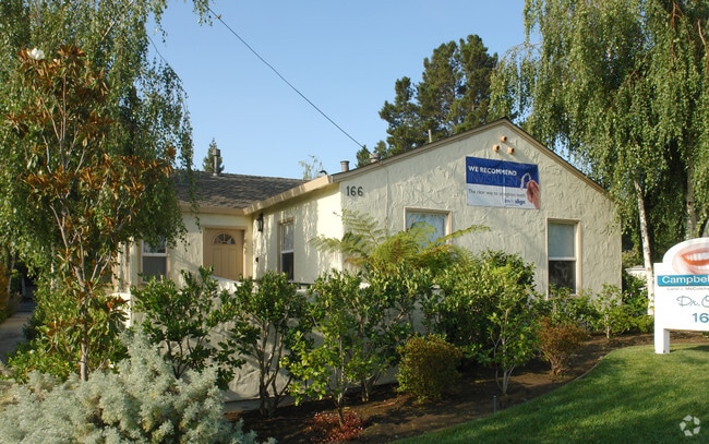
Property Record
166 W Campbell Ave, Campbell, CA 95008
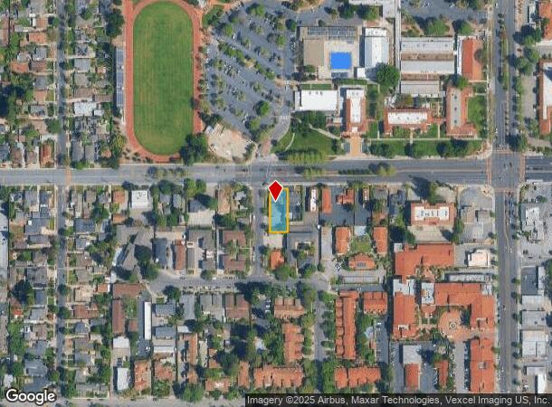

NEARBY LISTINGS FOR SALE OR LEASE
Property Detail
166 W Campbell Ave
305-31-040
Hedegard
Financialbuilding
TWP 07S RGE 01W SEC 34
X
Santa Clara
06085C0237H
California
2024
0.21 AC
2025
Campbell
506503
South Bay/San Jose
2,043 SF
San Jose-Sunnyvale-Santa Clara, CA
DEMOGRAPHICS near 166 W Campbell Ave
1 Mile
3 Mile
5 Mile
2024 Total Population
28,958
216,428
534,984
2029 Population
27,799
208,382
515,806
Pop Growth 2024-2029
(4.00%)
(3.72%)
(3.58%)
Average Age
39
40
40
2024 Total Households
11,492
81,049
196,503
HH Growth 2024-2029
(4.26%)
(3.95%)
(3.79%)
Median Household Inc
$107,944
$135,718
$146,549
Avg Household Size
2.40
2.60
2.60
2024 Avg HH Vehicles
2.00
2.00
2.00
Median Home Value
$1,093,277
$1,120,690
$1,120,826
Median Year Built
1972
1968
1968
Nearby Places
Map Layers
Map Styles
 Street
 Aerial
- Restaurants
- Banks
- Shops
- Fitness
- Groceries
PUBLIC TRANSPORTATION
COMMUTER RAIL
Tamien (Caltrain - Caltrain (Caltrain))
DRIVE
WALK
Distance
Tamien (Caltrain - Caltrain (Caltrain))
12 min
5.1 mi
DRIVE
WALK
Distance
11 min
6.2 mi
AIRPORT
Norman Y Mineta San Jose International
DRIVE
WALK
Distance
Norman Y Mineta San Jose International
12 min
7.4 mi
San Francisco International
DRIVE
WALK
Distance
San Francisco International
50 min
38.0 mi
Metro Oakland International
DRIVE
WALK
Distance
Metro Oakland International
51 min
40.7 mi
Freight Ports
Port of Redwood City
DRIVE
WALK
Distance
Port of Redwood City
35 min
24.9 mi
Nearby Properties
Address
Land Use
TOTAL SIZE
Lot Size
Zoning
Address
Land Use
TOTAL SIZE
Lot Size
Zoning
1,121,228 SF
7.68 AC
RM(PD
Address
Land Use
TOTAL SIZE
Lot Size
Zoning
4.56 AC
CP
Address
Land Use
TOTAL SIZE
Lot Size
Zoning
252,210 SF
15.85 AC
C2S
Address
Land Use
TOTAL SIZE
Lot Size
Zoning
457,162 SF
3.97 AC
A(PD)
Address
Land Use
TOTAL SIZE
Lot Size
Zoning
617,814 SF
21.96 AC
CG
Address
Land Use
TOTAL SIZE
Lot Size
Zoning
67,435 SF
11.93 AC
C2
Address
Land Use
TOTAL SIZE
Lot Size
Zoning
13.17 AC
C1
Address
Land Use
TOTAL SIZE
Lot Size
Zoning
3.40 AC
APD
Address
Land Use
TOTAL SIZE
Lot Size
Zoning
298,461 SF
5.45 AC
C3H
Address
Land Use
TOTAL SIZE
Lot Size
Zoning
4.75 AC
CP-PD
Address
Land Use
TOTAL SIZE
Lot Size
Zoning
222,000 SF
11.56 AC
IP
Address
Land Use
TOTAL SIZE
Lot Size
Zoning
234,622 SF
1.89 AC
A(PD)
Address
Land Use
TOTAL SIZE
Lot Size
Zoning
295,569 SF
30.70 AC
SJ
Address
Land Use
TOTAL SIZE
Lot Size
Zoning
116,953 SF
8.61 AC
C-2
Address
Land Use
TOTAL SIZE
Lot Size
Zoning
16.11 AC
CG
Address
Land Use
TOTAL SIZE
Lot Size
Zoning
279,360 SF
9.04 AC
R3
Address
Land Use
TOTAL SIZE
Lot Size
Zoning
4.04 AC
CT
Address
Land Use
TOTAL SIZE
Lot Size
Zoning
172,772 SF
3.47 AC
PD
Address
Land Use
TOTAL SIZE
Lot Size
Zoning
148,429 SF
0.97 AC
CMPD
Address
Land Use
TOTAL SIZE
Lot Size
Zoning
814,622 SF
14.57 AC
R3
Address
Land Use
TOTAL SIZE
Lot Size
Zoning
147,459 SF
0.97 AC
CMPD
Address
Land Use
TOTAL SIZE
Lot Size
Zoning
16,520 SF
6.18 AC
CC
Address
Land Use
TOTAL SIZE
Lot Size
Zoning
290,688 SF
8.45 AC
APD
Address
Land Use
TOTAL SIZE
Lot Size
Zoning
209,016 SF
8.50 AC
P-D
Address
Land Use
TOTAL SIZE
Lot Size
Zoning
237,928 SF
12.58 AC
APD
Address
Land Use
TOTAL SIZE
Lot Size
Zoning
190,044 SF
3.88 AC
P-D
Address
Land Use
TOTAL SIZE
Lot Size
Zoning
112,470 SF
1 AC
CMPD
Address
Land Use
TOTAL SIZE
Lot Size
Zoning
281,736 SF
9.67 AC
R3
Address
Land Use
TOTAL SIZE
Lot Size
Zoning
218,840 SF
11.73 AC
A-PD
The World's #1 Commercial Real Estate Marketplace
Connect with us
© 2026 CoStar Group
The information above has been obtained from sources believed reliable. While we do not doubt its accuracy we have not verified it and make no guarantee, warranty or representation about it. It is your responsibility to independently confirm its accuracy and completeness. Any projections, opinions, assumptions, or estimates used are for example only and do not represent the current or future performance of the property. The value of this transaction to you depends on tax and other factors which should be evaluated by your tax, financial, and legal advisors. You and your advisors should conduct a careful, independent investigation of the property to determine to your satisfaction the suitability of the property for your needs.