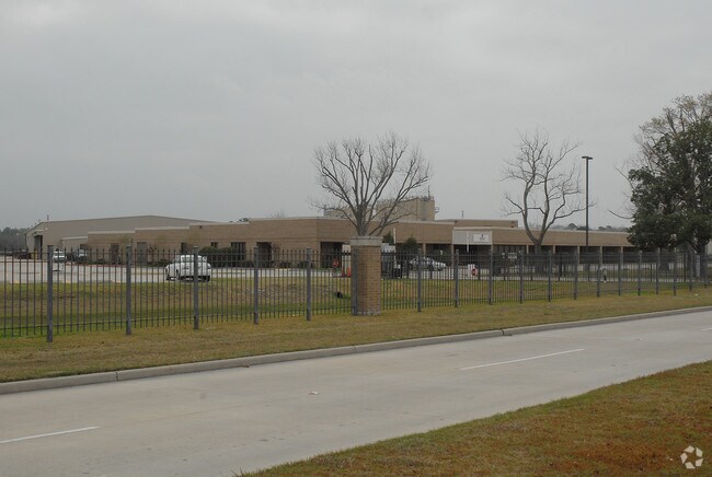
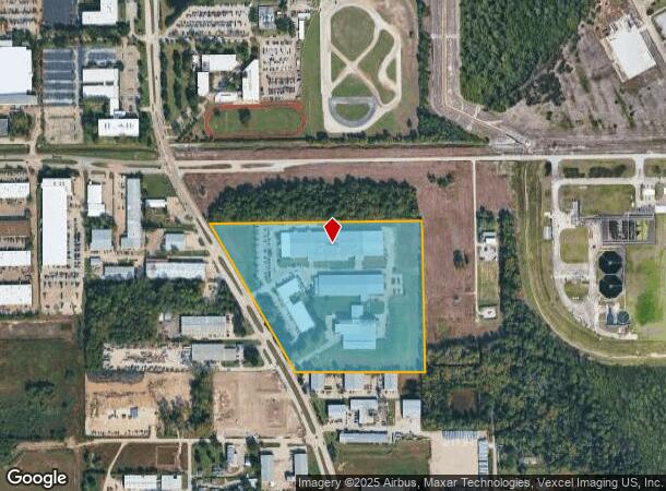
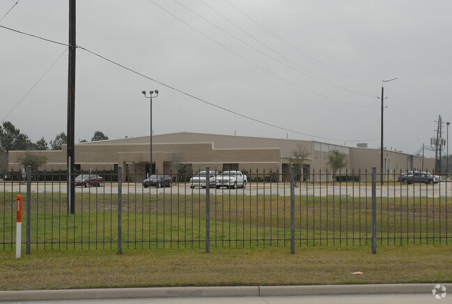
Property Record
16610 Aldine Westfield Rd, Houston, TX 77032

NEARBY LISTINGS FOR SALE OR LEASE
Property Detail
16610 Aldine Westfield Rd
1276810010001
Bj Services Company U S A
Outdoorrecreationbeachmountaindesert
RES A BLK 1 (PC IMPS*1276810010002) BJ SERVICES COMPANY U S A
X
Harris
48201C0480M
Texas
2024
22.76 AC
2025
North Hardy Toll Road
241503
Houston
202,930 SF
Houston-Pasadena-The Woodlands, TX
DEMOGRAPHICS near 16610 Aldine Westfield Rd
1 Mile
3 Mile
5 Mile
2024 Total Population
866
37,156
178,245
2029 Population
888
38,024
181,655
Pop Growth 2024-2029
+ 2.54%
+ 2.34%
+ 1.91%
Average Age
32
31
32
2024 Total Households
246
12,796
57,479
HH Growth 2024-2029
+ 2.03%
+ 2.46%
+ 2.02%
Median Household Inc
$32,500
$38,450
$39,718
Avg Household Size
3.40
2.90
3.00
2024 Avg HH Vehicles
2.00
2.00
2.00
Median Home Value
$64,903
$160,281
$150,041
Median Year Built
1989
1988
1987
Nearby Places
Map Layers
Map Styles
 Street
 Aerial
- Restaurants
- Banks
- Shops
- Fitness
- Groceries
PUBLIC TRANSPORTATION
AIRPORT
George Bush Intcntl/Houston
DRIVE
WALK
Distance
George Bush Intcntl/Houston
8 min
5.1 mi
William P Hobby
DRIVE
WALK
Distance
William P Hobby
45 min
28.9 mi
Freight Ports
Port of Houston
DRIVE
WALK
Distance
Port of Houston
33 min
22.8 mi
Nearby Properties
Address
Land Use
TOTAL SIZE
Lot Size
Zoning
Address
Land Use
TOTAL SIZE
Lot Size
Zoning
1,213,044 SF
69.99 AC
Address
Land Use
TOTAL SIZE
Lot Size
Zoning
1,767,053 SF
88.85 AC
Address
Land Use
TOTAL SIZE
Lot Size
Zoning
785,390 SF
66.02 AC
Address
Land Use
TOTAL SIZE
Lot Size
Zoning
621,700 SF
67.57 AC
Address
Land Use
TOTAL SIZE
Lot Size
Zoning
704,105 SF
40.72 AC
Address
Land Use
TOTAL SIZE
Lot Size
Zoning
657,500 SF
36.24 AC
Address
Land Use
TOTAL SIZE
Lot Size
Zoning
500,000 SF
24.58 AC
Address
Land Use
TOTAL SIZE
Lot Size
Zoning
502,325 SF
25.13 AC
Address
Land Use
TOTAL SIZE
Lot Size
Zoning
276,324 SF
33.79 AC
Address
Land Use
TOTAL SIZE
Lot Size
Zoning
379,570 SF
30.12 AC
Address
Land Use
TOTAL SIZE
Lot Size
Zoning
368,632 SF
20.06 AC
Address
Land Use
TOTAL SIZE
Lot Size
Zoning
338,700 SF
22.99 AC
Address
Land Use
TOTAL SIZE
Lot Size
Zoning
241,625 SF
11.10 AC
Address
Land Use
TOTAL SIZE
Lot Size
Zoning
394,784 SF
22.47 AC
Address
Land Use
TOTAL SIZE
Lot Size
Zoning
353,600 SF
23.45 AC
Address
Land Use
TOTAL SIZE
Lot Size
Zoning
448,760 SF
8.46 AC
Address
Land Use
TOTAL SIZE
Lot Size
Zoning
291,656 SF
18.94 AC
Address
Land Use
TOTAL SIZE
Lot Size
Zoning
435,650 SF
Address
Land Use
TOTAL SIZE
Lot Size
Zoning
57,551 SF
49.71 AC
Address
Land Use
TOTAL SIZE
Lot Size
Zoning
318,000 SF
18.53 AC
Address
Land Use
TOTAL SIZE
Lot Size
Zoning
257,000 SF
13.34 AC
Address
Land Use
TOTAL SIZE
Lot Size
Zoning
288,525 SF
17.66 AC
Address
Land Use
TOTAL SIZE
Lot Size
Zoning
597,462 SF
42.07 AC
Address
Land Use
TOTAL SIZE
Lot Size
Zoning
227,400 SF
19.37 AC
Address
Land Use
TOTAL SIZE
Lot Size
Zoning
208,008 SF
8.32 AC
Address
Land Use
TOTAL SIZE
Lot Size
Zoning
281,252 SF
8 AC
Address
Land Use
TOTAL SIZE
Lot Size
Zoning
215,879 SF
7.30 AC
Address
Land Use
TOTAL SIZE
Lot Size
Zoning
90,033 SF
46.96 AC
Address
Land Use
TOTAL SIZE
Lot Size
Zoning
239,270 SF
13.39 AC
Address
Land Use
TOTAL SIZE
Lot Size
Zoning
323,967 SF
13.21 AC
The World's #1 Commercial Real Estate Marketplace
Connect with us
© 2026 CoStar Group
The information above has been obtained from sources believed reliable. While we do not doubt its accuracy we have not verified it and make no guarantee, warranty or representation about it. It is your responsibility to independently confirm its accuracy and completeness. Any projections, opinions, assumptions, or estimates used are for example only and do not represent the current or future performance of the property. The value of this transaction to you depends on tax and other factors which should be evaluated by your tax, financial, and legal advisors. You and your advisors should conduct a careful, independent investigation of the property to determine to your satisfaction the suitability of the property for your needs.