Property Record
16620 Fm 1485 Rd, Conroe, TX 77306
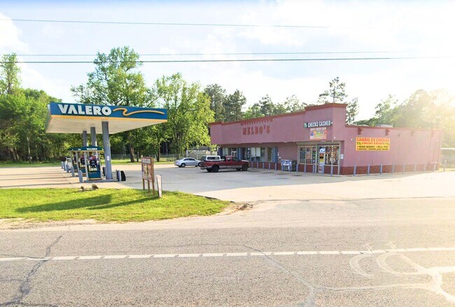

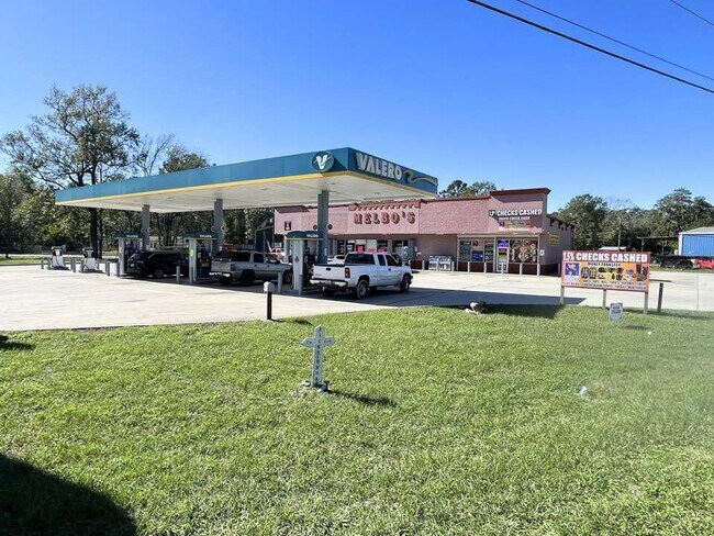
Property Detail
16620 Fm 1485 Rd
0420-00-00201
A0420 - PREWETT BEASLEY, TRACT 2-B, ACRES 0.882
Commercialnec
MONTGOMERY
C and X Area of minimal flood hazard, usually depicted on FIRMs as above the 500-year flood level.
Texas
2024
0.88 AC
2025
Montgomery County
692601
Houston
4,770 SF
Houston-Pasadena-The Woodlands, TX
NEARBY LISTINGS FOR SALE OR LEASE
DEMOGRAPHICS near 16620 Fm 1485 Rd
1 mile
3 mile
5 mile
2025 Total Population
1,992
13,271
45,502
2030 Population
2,356
15,915
54,743
Pop Growth 2025-2030
+ 18.27%
+ 19.92%
+ 20.31%
Average Age
37
38
36
2025 Total Households
635
4,352
14,665
HH Growth 2025-2030
+ 18.74%
+ 20.70%
+ 20.95%
Median Household Inc
$53,404
$59,477
$74,886
Avg Household Size
3.00
3.00
3.00
2025 Avg HH Vehicles
2.00
2.00
2.00
Median Home Value
$184,051
$196,663
$231,054
Median Year Built
2000
2006
2009
Nearby Places
Map Layers
Map Styles
 Street
 Aerial
Transit
 Traffic
 Biking
Places
Listings with unknown addresses are not visible on the map
- Restaurants
- Banks
- Shops
- Fitness
- Groceries
PUBLIC TRANSPORTATION
AIRPORT
George Bush Intcntl/Houston
Drive
Walk
Distance
George Bush Intcntl/Houston
32 min
24.8 mi
Freight Ports
Port of Houston
Drive
Walk
Distance
Port of Houston
53 min
40.1 mi
SALE & LEASE HISTORY
LISTING DATE
SALE/LEASE

Jan 09, 2025
For Lease
Nearby Properties
Address
Land Use
TOTAL SIZE
Lot Size
Zoning
Address
Land Use
TOTAL SIZE
Lot Size
Zoning
1,500,000 SF
86.90 AC
5
Address
Land Use
TOTAL SIZE
Lot Size
Zoning
1,014,160 SF
132.38 AC
Address
Land Use
TOTAL SIZE
Lot Size
Zoning
149,963 SF
49.98 AC
Address
Land Use
TOTAL SIZE
Lot Size
Zoning
126,871 SF
58.54 AC
1
Address
Land Use
TOTAL SIZE
Lot Size
Zoning
148,358 SF
16.01 AC
Address
Land Use
TOTAL SIZE
Lot Size
Zoning
137,928 SF
15.01 AC
Address
Land Use
TOTAL SIZE
Lot Size
Zoning
98,000 SF
18 AC
Address
Land Use
TOTAL SIZE
Lot Size
Zoning
61,628 SF
30.91 AC
5
Address
Land Use
TOTAL SIZE
Lot Size
Zoning
65,640 SF
9.37 AC
Address
Land Use
TOTAL SIZE
Lot Size
Zoning
62,788 SF
4 AC
Address
Land Use
TOTAL SIZE
Lot Size
Zoning
52,796 SF
6.58 AC
Address
Land Use
TOTAL SIZE
Lot Size
Zoning
43,820 SF
8.78 AC
Address
Land Use
TOTAL SIZE
Lot Size
Zoning
96,946 SF
12 AC
1
Address
Land Use
TOTAL SIZE
Lot Size
Zoning
31,428 SF
17.52 AC
Address
Land Use
TOTAL SIZE
Lot Size
Zoning
45,120 SF
9.73 AC
Address
Land Use
TOTAL SIZE
Lot Size
Zoning
49,320 SF
3 AC
5
Address
Land Use
TOTAL SIZE
Lot Size
Zoning
23,070 SF
10 AC
Address
Land Use
TOTAL SIZE
Lot Size
Zoning
55,225 SF
5 AC
Address
Land Use
TOTAL SIZE
Lot Size
Zoning
26,558 SF
12 AC
1
Address
Land Use
TOTAL SIZE
Lot Size
Zoning
31,250 SF
8.34 AC
Address
Land Use
TOTAL SIZE
Lot Size
Zoning
9,288 SF
1.99 AC
Address
Land Use
TOTAL SIZE
Lot Size
Zoning
37,500 SF
8.82 AC
Address
Land Use
TOTAL SIZE
Lot Size
Zoning
24,800 SF
6.89 AC
Address
Land Use
TOTAL SIZE
Lot Size
Zoning
19,200 SF
2.57 AC
Address
Land Use
TOTAL SIZE
Lot Size
Zoning
9,020 SF
1.54 AC
Address
Land Use
TOTAL SIZE
Lot Size
Zoning
9,180 SF
1.38 AC
1
Address
Land Use
TOTAL SIZE
Lot Size
Zoning
15,988 SF
46.22 AC
1
Address
Land Use
TOTAL SIZE
Lot Size
Zoning
19,939 SF
1.52 AC
1
Address
Land Use
TOTAL SIZE
Lot Size
Zoning
6,100 SF
2.84 AC
Address
Land Use
TOTAL SIZE
Lot Size
Zoning
1,440 SF
12.81 AC
1
The World's #1 Commercial Real Estate Marketplace
Connect with us
© 2026 CoStar Group
The information above has been obtained from sources believed reliable. While we do not doubt its accuracy we have not verified it and make no guarantee, warranty or representation about it. It is your responsibility to independently confirm its accuracy and completeness. Any projections, opinions, assumptions, or estimates used are for example only and do not represent the current or future performance of the property. The value of this transaction to you depends on tax and other factors which should be evaluated by your tax, financial, and legal advisors. You and your advisors should conduct a careful, independent investigation of the property to determine to your satisfaction the suitability of the property for your needs.