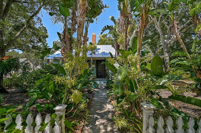
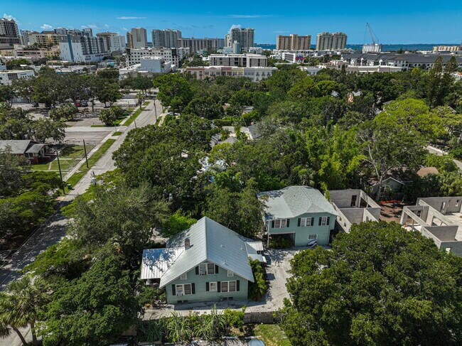
Property Record
1663 4Th St, Sarasota, FL 34236
NEARBY LISTINGS FOR SALE OR LEASE
Property Detail
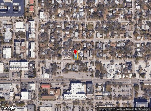
1663 4Th St
North Port-Bradenton-Sarasota, FL
Central Park Sub Unit 1
2026-10-0073
Sarasota
Duplex
Florida
X
0.13 AC
12115C0133G
Downtown Sarasota
1,859 SF
Tampa/St Petersburg
DEMOGRAPHICS near 1663 4Th St
1 Mile
3 Mile
5 Mile
2024 Total Population
16,993
75,424
158,168
2029 Population
19,800
85,770
180,599
Pop Growth 2024-2029
+ 16.52%
+ 13.72%
+ 14.18%
Average Age
52
46
48
2024 Total Households
8,920
33,919
72,626
HH Growth 2024-2029
+ 16.97%
+ 13.93%
+ 14.34%
Median Household Inc
$70,279
$61,490
$70,007
Avg Household Size
1.70
2.00
2.00
2024 Avg HH Vehicles
1.00
2.00
2.00
Median Home Value
$676,969
$329,893
$346,665
Median Year Built
1991
1975
1979
Nearby Places
Map Layers
Map Styles
 Street
 Aerial
- Restaurants
- Banks
- Shops
- Fitness
- Groceries
PUBLIC TRANSPORTATION
AIRPORT
Sarasota/Bradenton International
DRIVE
WALK
Distance
Sarasota/Bradenton International
10 min
4.9 mi
SALE & LEASE HISTORY
LISTING DATE
SALE/LEASE

Sep 24, 2024
For Sale
Nearby Properties
Address
Land Use
TOTAL SIZE
Lot Size
Zoning
Address
Land Use
TOTAL SIZE
Lot Size
Zoning
2,010,667 SF
14.38 AC
SMH
Address
Land Use
TOTAL SIZE
Lot Size
Zoning
843,350 SF
5.13 AC
DTC
Address
Land Use
TOTAL SIZE
Lot Size
Zoning
124,840 SF
29.18 AC
G
Address
Land Use
TOTAL SIZE
Lot Size
Zoning
516,332 SF
7.62 AC
DTB
Address
Land Use
TOTAL SIZE
Lot Size
Zoning
439,798 SF
4.20 AC
DTC
Address
Land Use
TOTAL SIZE
Lot Size
Zoning
595,734 SF
1.63 AC
DTB
Address
Land Use
TOTAL SIZE
Lot Size
Zoning
595,368 SF
13.76 AC
MCI
Address
Land Use
TOTAL SIZE
Lot Size
Zoning
458,955 SF
3.99 AC
DTE
Address
Land Use
TOTAL SIZE
Lot Size
Zoning
409,998 SF
1.09 AC
DTC
Address
Land Use
TOTAL SIZE
Lot Size
Zoning
950 SF
26.80 AC
G
Address
Land Use
TOTAL SIZE
Lot Size
Zoning
298,916 SF
36.99 AC
G
Address
Land Use
TOTAL SIZE
Lot Size
Zoning
394,304 SF
2.85 AC
DTE
Address
Land Use
TOTAL SIZE
Lot Size
Zoning
425,532 SF
3.05 AC
DTE
Address
Land Use
TOTAL SIZE
Lot Size
Zoning
309,573 SF
7.06 AC
ORD
Address
Land Use
TOTAL SIZE
Lot Size
Zoning
463,072 SF
2.21 AC
DTC
Address
Land Use
TOTAL SIZE
Lot Size
Zoning
1.70 AC
DTB
Address
Land Use
TOTAL SIZE
Lot Size
Zoning
223,241 SF
7.80 AC
DTE
Address
Land Use
TOTAL SIZE
Lot Size
Zoning
321,015 SF
1.11 AC
DTB
Address
Land Use
TOTAL SIZE
Lot Size
Zoning
91,324 SF
2.18 AC
SMH
Address
Land Use
TOTAL SIZE
Lot Size
Zoning
146,948 SF
1.08 AC
SMH
Address
Land Use
TOTAL SIZE
Lot Size
Zoning
199,653 SF
0.38 AC
DTC
Address
Land Use
TOTAL SIZE
Lot Size
Zoning
298,970 SF
38.78 AC
G
Address
Land Use
TOTAL SIZE
Lot Size
Zoning
19,464 SF
38.95 AC
G
Address
Land Use
TOTAL SIZE
Lot Size
Zoning
286,339 SF
44.66 AC
G
Address
Land Use
TOTAL SIZE
Lot Size
Zoning
211,459 SF
2.36 AC
DTC
Address
Land Use
TOTAL SIZE
Lot Size
Zoning
258,407 SF
18.55 AC
RMF3
Address
Land Use
TOTAL SIZE
Lot Size
Zoning
237,930 SF
1.58 AC
DTC
Address
Land Use
TOTAL SIZE
Lot Size
Zoning
112,310 SF
36.83 AC
G
Address
Land Use
TOTAL SIZE
Lot Size
Zoning
209,091 SF
21.30 AC
RMF3
Address
Land Use
TOTAL SIZE
Lot Size
Zoning
2,900 SF
152 AC
G
The World's #1 Commercial Real Estate Marketplace
Connect with us
© 2026 CoStar Group
The information above has been obtained from sources believed reliable. While we do not doubt its accuracy we have not verified it and make no guarantee, warranty or representation about it. It is your responsibility to independently confirm its accuracy and completeness. Any projections, opinions, assumptions, or estimates used are for example only and do not represent the current or future performance of the property. The value of this transaction to you depends on tax and other factors which should be evaluated by your tax, financial, and legal advisors. You and your advisors should conduct a careful, independent investigation of the property to determine to your satisfaction the suitability of the property for your needs.