Property Record
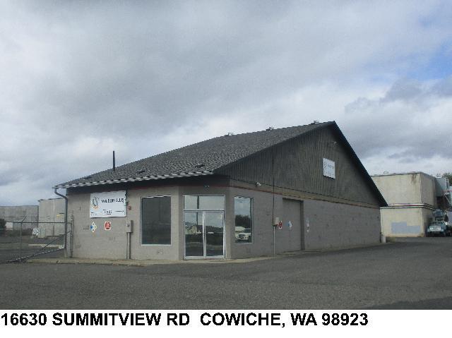
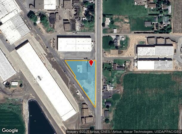
16630 Summitview Rd, Cowiche, WA 98923
NEARBY LISTINGS FOR SALE OR LEASE
-
-
View all Cowiche listings for sale on LoopNet.com
Property Detail
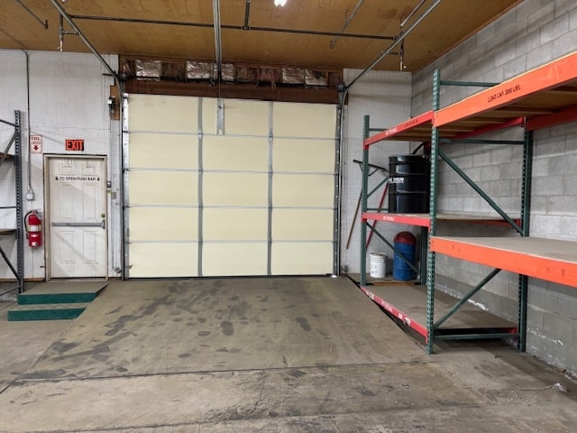
16630 Summitview Rd
171428-34006
SECTION 28 TOWNSHIP 14 RANGE 17 QUARTER SW: TH PT OF NE1/4 SE1/4 SW1/4 LY NELY OF B.N.RY R/W EX N 240 FT EX E 35 FT CO RD R/W
Wholesaleoutletdiscountstore
Yakima
X
Washington
53077C0687E
1.37 AC
2025
Outlying Yakima County
2025
Yakima
002900
Yakima, WA
2,983 SF
DEMOGRAPHICS near 16630 Summitview Rd
1 Mile
3 Mile
5 Mile
2024 Total Population
807
3,079
9,795
2029 Population
784
2,997
9,621
Pop Growth 2024-2029
(2.85%)
(2.66%)
(1.78%)
Average Age
37
38
39
2024 Total Households
263
1,011
3,295
HH Growth 2024-2029
(3.04%)
(2.87%)
(1.88%)
Median Household Inc
$60,395
$73,392
$69,726
Avg Household Size
3.00
3.00
2.90
2024 Avg HH Vehicles
2.00
3.00
3.00
Median Home Value
$425,961
$414,796
$317,009
Median Year Built
1979
1980
1974
Nearby Places
Map Layers
Map Styles
 Street
 Aerial
- Restaurants
- Banks
- Shops
- Fitness
- Groceries
PUBLIC TRANSPORTATION
AIRPORT
Yakima Air Trml/McAllister Field
DRIVE
WALK
Distance
Yakima Air Trml/McAllister Field
29 min
12.9 mi
SALE & LEASE HISTORY
LISTING DATE
SALE/LEASE

Sep 20, 2024
For Sale
Nearby Properties
Address
Land Use
TOTAL SIZE
Lot Size
Zoning
Address
Land Use
TOTAL SIZE
Lot Size
Zoning
102,018 SF
3.41 AC
RS
Address
Land Use
TOTAL SIZE
Lot Size
Zoning
242,289 SF
29.40 AC
M1
Address
Land Use
TOTAL SIZE
Lot Size
Zoning
315,292 SF
29.71 AC
AG
Address
Land Use
TOTAL SIZE
Lot Size
Zoning
61,604 SF
4.92 AC
RR
Address
Land Use
TOTAL SIZE
Lot Size
Zoning
115,277 SF
8.75 AC
AG
Address
Land Use
TOTAL SIZE
Lot Size
Zoning
149,661 SF
7.92 AC
M1
Address
Land Use
TOTAL SIZE
Lot Size
Zoning
209,488 SF
18.49 AC
RS
Address
Land Use
TOTAL SIZE
Lot Size
Zoning
84,424 SF
8.13 AC
AG
Address
Land Use
TOTAL SIZE
Lot Size
Zoning
111,408 SF
7.75 AC
RS
Address
Land Use
TOTAL SIZE
Lot Size
Zoning
48,525 SF
6.63 AC
R10/5
Address
Land Use
TOTAL SIZE
Lot Size
Zoning
11,064 SF
3.53 AC
RS
Address
Land Use
TOTAL SIZE
Lot Size
Zoning
5,837 SF
10.13 AC
RLDP
Address
Land Use
TOTAL SIZE
Lot Size
Zoning
11,780 SF
45.26 AC
AG
Address
Land Use
TOTAL SIZE
Lot Size
Zoning
8,480 SF
43.62 AC
AG
Address
Land Use
TOTAL SIZE
Lot Size
Zoning
4,830 SF
49.50 AC
RLDP
Address
Land Use
TOTAL SIZE
Lot Size
Zoning
5,009 SF
65.92 AC
AG
Address
Land Use
TOTAL SIZE
Lot Size
Zoning
16,690 SF
2.22 AC
AG
Address
Land Use
TOTAL SIZE
Lot Size
Zoning
4,035 SF
21.03 AC
RLDP
Address
Land Use
TOTAL SIZE
Lot Size
Zoning
5,067 SF
25.40 AC
AG
Address
Land Use
TOTAL SIZE
Lot Size
Zoning
34,565 SF
13.56 AC
AG
Address
Land Use
TOTAL SIZE
Lot Size
Zoning
8,818 SF
10.50 AC
R10/5
Address
Land Use
TOTAL SIZE
Lot Size
Zoning
14,527 SF
0.90 AC
RS
Address
Land Use
TOTAL SIZE
Lot Size
Zoning
5,806 SF
1.08 AC
RS
Address
Land Use
TOTAL SIZE
Lot Size
Zoning
4,456 SF
31.76 AC
AG
Address
Land Use
TOTAL SIZE
Lot Size
Zoning
5,089 SF
18.92 AC
RLDP
Address
Land Use
TOTAL SIZE
Lot Size
Zoning
3,117 SF
22.91 AC
AG
Address
Land Use
TOTAL SIZE
Lot Size
Zoning
6,880 SF
8.53 AC
AG
Address
Land Use
TOTAL SIZE
Lot Size
Zoning
4,234 SF
60.95 AC
RLDP
Address
Land Use
TOTAL SIZE
Lot Size
Zoning
5,169 SF
62.10 AC
AG
The World's #1 Commercial Real Estate Marketplace
Connect with us
© 2025 CoStar Group
The information above has been obtained from sources believed reliable. While we do not doubt its accuracy we have not verified it and make no guarantee, warranty or representation about it. It is your responsibility to independently confirm its accuracy and completeness. Any projections, opinions, assumptions, or estimates used are for example only and do not represent the current or future performance of the property. The value of this transaction to you depends on tax and other factors which should be evaluated by your tax, financial, and legal advisors. You and your advisors should conduct a careful, independent investigation of the property to determine to your satisfaction the suitability of the property for your needs.