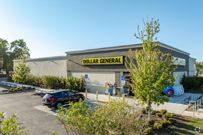
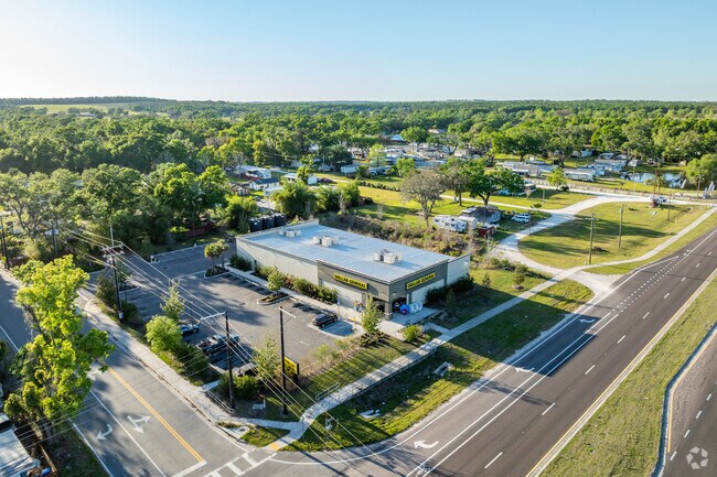
Property Record
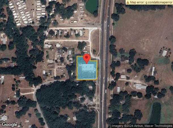
16635 Us Highway 301 Rd, Dade City, FL 33523
NEARBY LISTINGS FOR SALE OR LEASE
Property Detail
16635 Us Highway 301 Rd
Tampa-St. Petersburg-Clearwater, FL
COM AT SE COR OF NORTH 1/2 OF SE1/4 OF NW1/4 OF SEC 15 TH S89DEG5001W 101.56 FT TO PT ON EXISTING WEST R/W US HWY 301 FOR POB TH S89DEG5001W 240.00 FT TH N00DEG1303E 300.01 FT TH N89DEG5001E 160.60 FT TH S00DEG1303W 53.25 FTTH N89DEG5001E 83.08 FT TO
15-24-21-0000-00800-0010
Pasco
Storebuilding
Florida
2024
1
2026
1.46 AC
032401
Pasco County
11,828 SF
Tampa/St Petersburg
DEMOGRAPHICS near 16635 Us Highway 301 Rd
1 Mile
3 Mile
5 Mile
2024 Total Population
1,266
13,820
25,892
2029 Population
1,505
16,664
31,299
Pop Growth 2024-2029
+ 18.88%
+ 20.58%
+ 20.88%
Average Age
37
38
40
2024 Total Households
442
4,859
9,475
HH Growth 2024-2029
+ 18.78%
+ 20.62%
+ 20.85%
Median Household Inc
$49,582
$54,359
$57,912
Avg Household Size
2.70
2.70
2.60
2024 Avg HH Vehicles
2.00
2.00
2.00
Median Home Value
$215,517
$193,063
$230,769
Median Year Built
1980
1977
1983
Nearby Places
Map Layers
Map Styles
 Street
 Aerial
- Restaurants
- Banks
- Shops
- Fitness
- Groceries
SALE & LEASE HISTORY
LISTING DATE
SALE/LEASE

May 03, 2022
For Sale
Nearby Properties
Address
Land Use
TOTAL SIZE
Lot Size
Zoning
Address
Land Use
TOTAL SIZE
Lot Size
Zoning
119,784 SF
7.79 AC
RIO
Address
Land Use
TOTAL SIZE
Lot Size
Zoning
118,676 SF
80.02 AC
RIO
Address
Land Use
TOTAL SIZE
Lot Size
Zoning
320,071 SF
23.74 AC
PDEC
Address
Land Use
TOTAL SIZE
Lot Size
Zoning
82,689 SF
19.18 AC
RG1
Address
Land Use
TOTAL SIZE
Lot Size
Zoning
76,418 SF
2.78 AC
RIO
Address
Land Use
TOTAL SIZE
Lot Size
Zoning
84,706 SF
13.65 AC
RIO
Address
Land Use
TOTAL SIZE
Lot Size
Zoning
70,032 SF
12.80 AC
MPUD
Address
Land Use
TOTAL SIZE
Lot Size
Zoning
64,520 SF
11.65 AC
I2
Address
Land Use
TOTAL SIZE
Lot Size
Zoning
65,354 SF
15 AC
RIO
Address
Land Use
TOTAL SIZE
Lot Size
Zoning
131,580 SF
3.84 AC
PDEC
Address
Land Use
TOTAL SIZE
Lot Size
Zoning
130,200 SF
0.74 AC
CBD
Address
Land Use
TOTAL SIZE
Lot Size
Zoning
41,400 SF
4.91 AC
PDEC
Address
Land Use
TOTAL SIZE
Lot Size
Zoning
132,517 SF
10.26 AC
I2
Address
Land Use
TOTAL SIZE
Lot Size
Zoning
20,070 SF
1.62 AC
CBD
Address
Land Use
TOTAL SIZE
Lot Size
Zoning
64,226 SF
23 AC
RG1
Address
Land Use
TOTAL SIZE
Lot Size
Zoning
32,912 SF
1.98 AC
C2
Address
Land Use
TOTAL SIZE
Lot Size
Zoning
114,408 SF
3.78 AC
PDEC
Address
Land Use
TOTAL SIZE
Lot Size
Zoning
36,680 SF
8.75 AC
RIO
Address
Land Use
TOTAL SIZE
Lot Size
Zoning
13,064 SF
1.36 AC
RIO
Address
Land Use
TOTAL SIZE
Lot Size
Zoning
18,592 SF
1.08 AC
RS3
Address
Land Use
TOTAL SIZE
Lot Size
Zoning
35,844 SF
4.25 AC
MF1
Address
Land Use
TOTAL SIZE
Lot Size
Zoning
43,294 SF
2.66 AC
RS2
Address
Land Use
TOTAL SIZE
Lot Size
Zoning
16,957 SF
1.25 AC
RIO
Address
Land Use
TOTAL SIZE
Lot Size
Zoning
13,992 SF
1.01 AC
CBD
Address
Land Use
TOTAL SIZE
Lot Size
Zoning
30,848 SF
1.55 AC
RIO
Address
Land Use
TOTAL SIZE
Lot Size
Zoning
15,170 SF
0.48 AC
CBD
Address
Land Use
TOTAL SIZE
Lot Size
Zoning
50,450 SF
3.88 AC
CG
Address
Land Use
TOTAL SIZE
Lot Size
Zoning
6,260 SF
0.56 AC
CBD
Address
Land Use
TOTAL SIZE
Lot Size
Zoning
56,474 SF
29 AC
AC1
Address
Land Use
TOTAL SIZE
Lot Size
Zoning
18,664 SF
3.75 AC
RS2
The World's #1 Commercial Real Estate Marketplace
Connect with us
© 2026 CoStar Group
The information above has been obtained from sources believed reliable. While we do not doubt its accuracy we have not verified it and make no guarantee, warranty or representation about it. It is your responsibility to independently confirm its accuracy and completeness. Any projections, opinions, assumptions, or estimates used are for example only and do not represent the current or future performance of the property. The value of this transaction to you depends on tax and other factors which should be evaluated by your tax, financial, and legal advisors. You and your advisors should conduct a careful, independent investigation of the property to determine to your satisfaction the suitability of the property for your needs.