Property Record
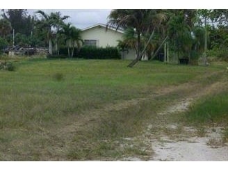
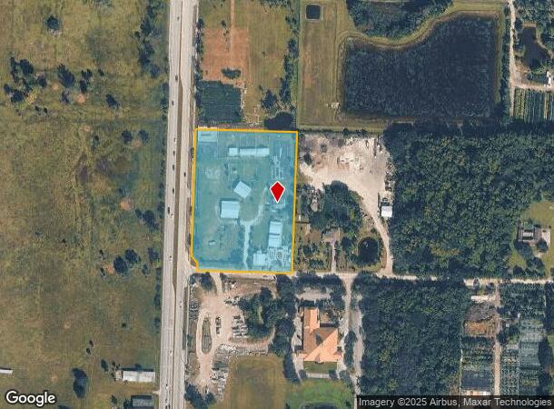
16651 Rembrandt Rd, Loxahatchee, FL 33470
NEARBY LISTINGS FOR SALE OR LEASE
Property Detail
16651 Rembrandt Rd
00-40-43-36-00-000-2130
Entrada Acres
Stable
36-43-40~ PT OF W 3/4 OF SEC LYG E OF & ADJ TO SEMINOLE PRATT WHITNEY RD & N OF & ADJ TO SR 80 R/WS K/A TR 13 ENTRADA ACRES UNREC IN OR2831P235
AE
Palm Beach
12099C0541F
Florida
2024
4.86 AC
2025
Palm Bch Cty Outlying
007851
South Florida
1,386 SF
West Palm Beach-Boca Raton-Delray Beach, FL
DEMOGRAPHICS near 16651 Rembrandt Rd
1 Mile
3 Mile
5 Mile
2024 Total Population
818
14,294
55,793
2029 Population
824
14,650
57,392
Pop Growth 2024-2029
+ 0.73%
+ 2.49%
+ 2.87%
Average Age
42
40
40
2024 Total Households
259
4,548
18,940
HH Growth 2024-2029
0.00%
+ 1.58%
+ 2.10%
Median Household Inc
$118,877
$122,640
$102,221
Avg Household Size
2.90
3.00
2.80
2024 Avg HH Vehicles
3.00
2.00
2.00
Median Home Value
$664,285
$544,070
$432,440
Median Year Built
1990
1991
1991
Nearby Places
Map Layers
Map Styles
 Street
 Aerial
- Restaurants
- Banks
- Shops
- Fitness
- Groceries
PUBLIC TRANSPORTATION
AIRPORT
Palm Beach International
DRIVE
WALK
Distance
Palm Beach International
23 min
14.2 mi
Freight Ports
Port of Palm Beach
DRIVE
WALK
Distance
Port of Palm Beach
37 min
21.8 mi
Nearby Properties
Address
Land Use
TOTAL SIZE
Lot Size
Zoning
Address
Land Use
TOTAL SIZE
Lot Size
Zoning
54,192 SF
74.82 AC
AR
Address
Land Use
TOTAL SIZE
Lot Size
Zoning
152,455 SF
33.77 AC
PUD
Address
Land Use
TOTAL SIZE
Lot Size
Zoning
122,559 SF
15 AC
PUD
Address
Land Use
TOTAL SIZE
Lot Size
Zoning
98,538 SF
2.45 AC
CL
Address
Land Use
TOTAL SIZE
Lot Size
Zoning
63,826 SF
8.22 AC
CL
Address
Land Use
TOTAL SIZE
Lot Size
Zoning
35,390 SF
631.36 AC
MUPD
Address
Land Use
TOTAL SIZE
Lot Size
Zoning
61,105 SF
32.10 AC
AR
Address
Land Use
TOTAL SIZE
Lot Size
Zoning
69,124 SF
29.91 AC
PO
Address
Land Use
TOTAL SIZE
Lot Size
Zoning
63,105 SF
51.62 AC
PUD
Address
Land Use
TOTAL SIZE
Lot Size
Zoning
294 SF
28.79 AC
PO
Address
Land Use
TOTAL SIZE
Lot Size
Zoning
171.13 AC
PUD
Address
Land Use
TOTAL SIZE
Lot Size
Zoning
19,263 SF
2.44 AC
MUPD
Address
Land Use
TOTAL SIZE
Lot Size
Zoning
20,370 SF
3.44 AC
CL
Address
Land Use
TOTAL SIZE
Lot Size
Zoning
632.55 AC
STA/AR
Address
Land Use
TOTAL SIZE
Lot Size
Zoning
10,475 SF
2.37 AC
PUD
Address
Land Use
TOTAL SIZE
Lot Size
Zoning
18,327 SF
15.19 AC
AR
Address
Land Use
TOTAL SIZE
Lot Size
Zoning
629.21 AC
STA/AR
Address
Land Use
TOTAL SIZE
Lot Size
Zoning
6,120 SF
1.61 AC
MUPD
Address
Land Use
TOTAL SIZE
Lot Size
Zoning
4,947 SF
1.52 AC
MUPD
Address
Land Use
TOTAL SIZE
Lot Size
Zoning
1,680 SF
19.51 AC
CRE
Address
Land Use
TOTAL SIZE
Lot Size
Zoning
470.44 AC
STA/AR
Address
Land Use
TOTAL SIZE
Lot Size
Zoning
22,380 SF
5.90 AC
CL
Address
Land Use
TOTAL SIZE
Lot Size
Zoning
19,426 SF
4.93 AC
CC
Address
Land Use
TOTAL SIZE
Lot Size
Zoning
4,741 SF
1.40 AC
MUPD
Address
Land Use
TOTAL SIZE
Lot Size
Zoning
7,334 SF
2.69 AC
PUD
Address
Land Use
TOTAL SIZE
Lot Size
Zoning
8,088 SF
2.90 AC
PUD
Address
Land Use
TOTAL SIZE
Lot Size
Zoning
10,496 SF
10 AC
AR
Address
Land Use
TOTAL SIZE
Lot Size
Zoning
10,362 SF
2.15 AC
PUD
Address
Land Use
TOTAL SIZE
Lot Size
Zoning
5,220 SF
0.82 AC
CL
Address
Land Use
TOTAL SIZE
Lot Size
Zoning
4,633 SF
2.90 AC
PUD
The World's #1 Commercial Real Estate Marketplace
Connect with us
© 2025 CoStar Group
The information above has been obtained from sources believed reliable. While we do not doubt its accuracy we have not verified it and make no guarantee, warranty or representation about it. It is your responsibility to independently confirm its accuracy and completeness. Any projections, opinions, assumptions, or estimates used are for example only and do not represent the current or future performance of the property. The value of this transaction to you depends on tax and other factors which should be evaluated by your tax, financial, and legal advisors. You and your advisors should conduct a careful, independent investigation of the property to determine to your satisfaction the suitability of the property for your needs.