Property Record
1667 E Dixon Blvd, Shelby, NC 28152

Save to a Folder
{{folder.Name}}
{{folder.ListingIds.length}} Properties
{{folder.ListingIds.length}} Property
Create a New Folder
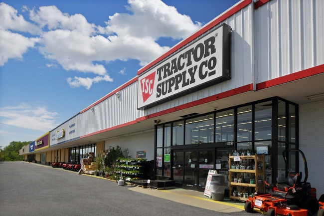
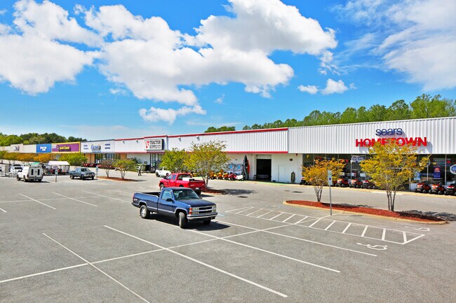
Property Detail
1667 E Dixon Blvd
26359
13.65AC PB47-115 HWY 74 E PER NEW SURVEY
Commercialnec
Cleveland
GB
North Carolina
B and X Area of moderate flood hazard, usually the area between the limits of the 100-year and 500-year floods.
1
2025
13.65 AC
2025
Cleveland County
950702
Charlotte
103,000 SF
Shelby-Kings Mountain, NC
NEARBY LISTINGS FOR SALE OR LEASE
-
-
-
-
-
No Photo
-
-
-
View all Shelby listings for lease on LoopNet.com
DEMOGRAPHICS near 1667 E Dixon Blvd
1 mile
3 mile
5 mile
2025 Total Population
2,104
23,888
39,109
2030 Population
2,128
24,501
40,025
Pop Growth 2025-2030
+ 1.14%
+ 2.57%
+ 2.34%
Average Age
43
41
42
2025 Total Households
884
10,061
16,197
HH Growth 2025-2030
+ 1.13%
+ 2.51%
+ 2.31%
Median Household Inc
$88,732
$53,487
$58,534
Avg Household Size
2.30
2.20
2.30
2025 Avg HH Vehicles
2.00
2.00
2.00
Median Home Value
$244,881
$227,053
$237,303
Median Year Built
1974
1973
1977
Nearby Places
Map Layers
Map Styles
 Street
 Aerial
Layers
 Traffic
 Biking
Places
Listings with unknown addresses are not visible on the map
- Restaurants
- Banks
- Shops
- Fitness
- Groceries
SALE & LEASE HISTORY
LISTING DATE
SALE/LEASE

Sep 25, 2016
For Lease
Nearby Properties
Address
Land Use
TOTAL SIZE
Lot Size
Zoning
Address
Land Use
TOTAL SIZE
Lot Size
Zoning
15.70 AC
RO
Address
Land Use
TOTAL SIZE
Lot Size
Zoning
5,036 SF
29.46 AC
CPD
Address
Land Use
TOTAL SIZE
Lot Size
Zoning
92,278 SF
41.63 AC
R10
Address
Land Use
TOTAL SIZE
Lot Size
Zoning
12.80 AC
R10
Address
Land Use
TOTAL SIZE
Lot Size
Zoning
139,067 SF
25 AC
R20
Address
Land Use
TOTAL SIZE
Lot Size
Zoning
29,747 SF
21.06 AC
RO
Address
Land Use
TOTAL SIZE
Lot Size
Zoning
9.55 AC
RO
Address
Land Use
TOTAL SIZE
Lot Size
Zoning
8,712 SF
13.95 AC
R6
Address
Land Use
TOTAL SIZE
Lot Size
Zoning
224,162 SF
15 AC
GBCU
Address
Land Use
TOTAL SIZE
Lot Size
Zoning
8,880 SF
8.28 AC
CPD
Address
Land Use
TOTAL SIZE
Lot Size
Zoning
253,504 SF
30.57 AC
LI
Address
Land Use
TOTAL SIZE
Lot Size
Zoning
18,864 SF
10.65 AC
ROCU
Address
Land Use
TOTAL SIZE
Lot Size
Zoning
1,436 SF
8.02 AC
RO
Address
Land Use
TOTAL SIZE
Lot Size
Zoning
17,634 SF
19.06 AC
GB
Address
Land Use
TOTAL SIZE
Lot Size
Zoning
66,184 SF
56.38 AC
ROCU
Address
Land Use
TOTAL SIZE
Lot Size
Zoning
4,040 SF
22.83 AC
GB
Address
Land Use
TOTAL SIZE
Lot Size
Zoning
24,652 SF
3.72 AC
R10
Address
Land Use
TOTAL SIZE
Lot Size
Zoning
71,644 SF
7.67 AC
GB
Address
Land Use
TOTAL SIZE
Lot Size
Zoning
44,684 SF
4.44 AC
RO
Address
Land Use
TOTAL SIZE
Lot Size
Zoning
50,771 SF
2.40 AC
GB
Address
Land Use
TOTAL SIZE
Lot Size
Zoning
52.33 AC
R8
Address
Land Use
TOTAL SIZE
Lot Size
Zoning
63,543 SF
24.07 AC
R20
Address
Land Use
TOTAL SIZE
Lot Size
Zoning
46,948 SF
2.06 AC
GB
Address
Land Use
TOTAL SIZE
Lot Size
Zoning
78,165 SF
8.02 AC
GB
Address
Land Use
TOTAL SIZE
Lot Size
Zoning
134,978 SF
14.50 AC
GB2CU
Address
Land Use
TOTAL SIZE
Lot Size
Zoning
37,580 SF
2 AC
GB
Address
Land Use
TOTAL SIZE
Lot Size
Zoning
43,540 SF
2.96 AC
GI
Address
Land Use
TOTAL SIZE
Lot Size
Zoning
36,511 SF
11.57 AC
GB2
Address
Land Use
TOTAL SIZE
Lot Size
Zoning
159,172 SF
30.75 AC
GB
Address
Land Use
TOTAL SIZE
Lot Size
Zoning
93.55 AC
R10
The World's #1 Commercial Real Estate Marketplace
Connect with us
© 2026 CoStar Group
The information above has been obtained from sources believed reliable. While we do not doubt its accuracy we have not verified it and make no guarantee, warranty or representation about it. It is your responsibility to independently confirm its accuracy and completeness. Any projections, opinions, assumptions, or estimates used are for example only and do not represent the current or future performance of the property. The value of this transaction to you depends on tax and other factors which should be evaluated by your tax, financial, and legal advisors. You and your advisors should conduct a careful, independent investigation of the property to determine to your satisfaction the suitability of the property for your needs.