Property Record
1667 Highway 183, Leander, TX 78641
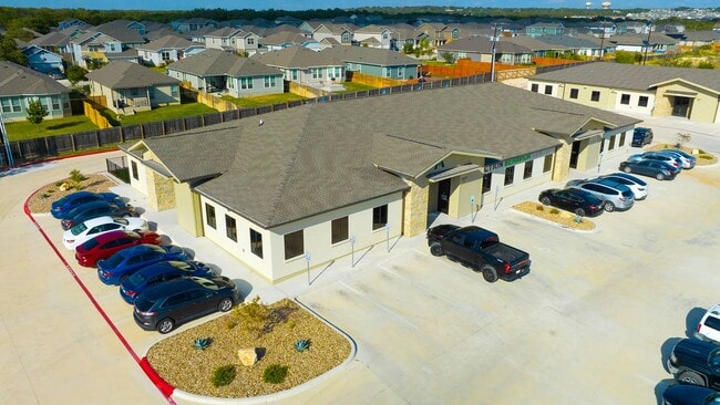

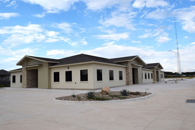
Property Detail
1667 Highway 183
Austin-Round Rock-San Marcos, TX
S12034 - HIGHLAND 183 SUB (BLK A LT 3 AMD), BLOCK A, LOT 3A, ACRES 3.0796
R584344
WILLIAMSON
Commercialnec
Texas
B and X Area of moderate flood hazard, usually the area between the limits of the 100-year and 500-year floods.
3,3a
2024
3.08 AC
2025
Georgetown
020338
Austin
14,499 SF
NEARBY LISTINGS FOR SALE OR LEASE
DEMOGRAPHICS near 1667 Highway 183
1 mile
3 mile
5 mile
2025 Total Population
8,745
38,892
88,972
2030 Population
10,379
46,709
105,877
Pop Growth 2025-2030
+ 18.68%
+ 20.10%
+ 19.00%
Average Age
34
35
36
2025 Total Households
2,932
13,155
30,692
HH Growth 2025-2030
+ 19.17%
+ 20.52%
+ 19.43%
Median Household Inc
$111,127
$129,149
$130,329
Avg Household Size
3.00
2.90
2.90
2025 Avg HH Vehicles
2.00
2.00
2.00
Median Home Value
$429,275
$465,627
$482,675
Median Year Built
2011
2011
2011
Nearby Places
Map Layers
Map Styles
 Street
 Aerial
Transit
 Traffic
 Biking
Places
Listings with unknown addresses are not visible on the map
- Restaurants
- Banks
- Shops
- Fitness
- Groceries
PUBLIC TRANSPORTATION
AIRPORT
Robert Gray AAF
Drive
Walk
Distance
Robert Gray AAF
57 min
36.2 mi
Freight Ports
Calhoun Port
Drive
Walk
Distance
Calhoun Port
220 min
185.6 mi
SALE & LEASE HISTORY
LISTING DATE
SALE/LEASE

Oct 29, 2020
For Sale
May 09, 2019
For Sale
May 09, 2019
For Sale
Mar 28, 2019
For Sale
Mar 28, 2019
For Sale
Mar 27, 2023
For Sale
Mar 15, 2019
For Lease
Apr 01, 2019
For Lease
Nearby Properties
Address
Land Use
TOTAL SIZE
Lot Size
Zoning
Address
Land Use
TOTAL SIZE
Lot Size
Zoning
454,000 SF
58.85 AC
Address
Land Use
TOTAL SIZE
Lot Size
Zoning
435,000 SF
88.70 AC
Address
Land Use
TOTAL SIZE
Lot Size
Zoning
287,118 SF
9.26 AC
Address
Land Use
TOTAL SIZE
Lot Size
Zoning
325,045 SF
11.40 AC
Address
Land Use
TOTAL SIZE
Lot Size
Zoning
156,000 SF
67.68 AC
Address
Land Use
TOTAL SIZE
Lot Size
Zoning
285,365 SF
12.24 AC
Address
Land Use
TOTAL SIZE
Lot Size
Zoning
312,374 SF
15.77 AC
Address
Land Use
TOTAL SIZE
Lot Size
Zoning
232,172 SF
10.43 AC
Address
Land Use
TOTAL SIZE
Lot Size
Zoning
341,700 SF
9.90 AC
Address
Land Use
TOTAL SIZE
Lot Size
Zoning
286,888 SF
20.68 AC
Address
Land Use
TOTAL SIZE
Lot Size
Zoning
193,600 SF
70.78 AC
Address
Land Use
TOTAL SIZE
Lot Size
Zoning
247,584 SF
18.45 AC
Address
Land Use
TOTAL SIZE
Lot Size
Zoning
Address
Land Use
TOTAL SIZE
Lot Size
Zoning
194,695 SF
9.56 AC
Address
Land Use
TOTAL SIZE
Lot Size
Zoning
1,971 SF
52.04 AC
Address
Land Use
TOTAL SIZE
Lot Size
Zoning
109,663 SF
19.54 AC
Address
Land Use
TOTAL SIZE
Lot Size
Zoning
11.98 AC
Address
Land Use
TOTAL SIZE
Lot Size
Zoning
194,695 SF
5.09 AC
Address
Land Use
TOTAL SIZE
Lot Size
Zoning
256,008 SF
15.88 AC
Address
Land Use
TOTAL SIZE
Lot Size
Zoning
35,223 SF
9.75 AC
Address
Land Use
TOTAL SIZE
Lot Size
Zoning
37,809 SF
6.26 AC
Address
Land Use
TOTAL SIZE
Lot Size
Zoning
127,329 SF
32.79 AC
Address
Land Use
TOTAL SIZE
Lot Size
Zoning
39,180 SF
9.28 AC
Address
Land Use
TOTAL SIZE
Lot Size
Zoning
60,305 SF
0.87 AC
Address
Land Use
TOTAL SIZE
Lot Size
Zoning
1,412 SF
20.17 AC
Address
Land Use
TOTAL SIZE
Lot Size
Zoning
46,979 SF
5.56 AC
Address
Land Use
TOTAL SIZE
Lot Size
Zoning
40.21 AC
Address
Land Use
TOTAL SIZE
Lot Size
Zoning
308,888 SF
34.18 AC
Address
Land Use
TOTAL SIZE
Lot Size
Zoning
67,651 SF
2.68 AC
Address
Land Use
TOTAL SIZE
Lot Size
Zoning
111,000 SF
15.27 AC
The World's #1 Commercial Real Estate Marketplace
Connect with us
© 2026 CoStar Group
The information above has been obtained from sources believed reliable. While we do not doubt its accuracy we have not verified it and make no guarantee, warranty or representation about it. It is your responsibility to independently confirm its accuracy and completeness. Any projections, opinions, assumptions, or estimates used are for example only and do not represent the current or future performance of the property. The value of this transaction to you depends on tax and other factors which should be evaluated by your tax, financial, and legal advisors. You and your advisors should conduct a careful, independent investigation of the property to determine to your satisfaction the suitability of the property for your needs.