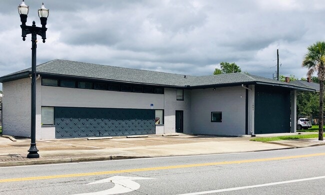
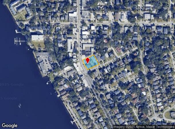
Property Record
1665 San Marco Blvd, Jacksonville, FL 32207
NEARBY LISTINGS FOR SALE OR LEASE
Property Detail
1665 San Marco Blvd
Jacksonville, FL
Ideal Investment Co S S/D
081108-0000
7-37 44-2S-26E .438 IDEAL INVESTMENT CO S/D RIVIERA LOTS 5,6,PT LOT 7 RECD O/R 7290-1224 (EX PT R/W RECD O/R 15316-2479 BEING PARCEL 108) BLK 2
Regionalshoppingcenterormallwithanchorstore
Duval
AE
Florida
12031C0366J
5,6,7
2024
0.44 AC
2025
Downtown Southbank
000800
Jacksonville (Florida)
3,686 SF
DEMOGRAPHICS near 1665 San Marco Blvd
1 Mile
3 Mile
5 Mile
2024 Total Population
6,777
73,964
209,933
2029 Population
7,346
78,770
221,938
Pop Growth 2024-2029
+ 8.40%
+ 6.50%
+ 5.72%
Average Age
43
40
39
2024 Total Households
3,742
32,900
88,477
HH Growth 2024-2029
+ 8.50%
+ 6.91%
+ 5.94%
Median Household Inc
$60,873
$44,690
$43,178
Avg Household Size
1.80
2.00
2.20
2024 Avg HH Vehicles
1.00
1.00
1.00
Median Home Value
$373,360
$283,570
$201,783
Median Year Built
1977
1958
1960
Nearby Places
- Restaurants
- Banks
- Shops
- Fitness
- Groceries
PUBLIC TRANSPORTATION
TRANSIT/SUBWAY
San Marco (Skyway - Jacksonville Transit Authority Skyway (The Skyway))
DRIVE
WALK
Distance
San Marco (Skyway - Jacksonville Transit Authority Skyway (The Skyway))
5 min
14 min
0.8 mi
Kings Ave Station (Skyway - Jacksonville Transportation Authority)
DRIVE
WALK
Distance
Kings Ave Station (Skyway - Jacksonville Transportation Authority)
2 min
17 min
0.9 mi
Kings Avenue (Skyway - Jacksonville Transit Authority Skyway (The Skyway))
DRIVE
WALK
Distance
Kings Avenue (Skyway - Jacksonville Transit Authority Skyway (The Skyway))
3 min
17 min
0.9 mi
Riverplace (Skyway - Jacksonville Transit Authority Skyway (The Skyway))
DRIVE
WALK
Distance
Riverplace (Skyway - Jacksonville Transit Authority Skyway (The Skyway))
2 min
17 min
0.9 mi
COMMUTER RAIL
Jacksonville (Silver Meteor - Amtrak, Silver Star - Amtrak)
DRIVE
WALK
Distance
Jacksonville (Silver Meteor - Amtrak, Silver Star - Amtrak)
14 min
8.5 mi
AIRPORT
Jacksonville International
DRIVE
WALK
Distance
Jacksonville International
26 min
17.0 mi
Freight Ports
Jacksonville Port
DRIVE
WALK
Distance
Jacksonville Port
13 min
5.9 mi
SALE & LEASE HISTORY
LISTING DATE
SALE/LEASE

Feb 28, 2023
For Lease
Aug 03, 2020
For Lease
Nearby Properties
Address
Land Use
TOTAL SIZE
Lot Size
Zoning
Address
Land Use
TOTAL SIZE
Lot Size
Zoning
1,086,885 SF
16.83 AC
CCBD
Address
Land Use
TOTAL SIZE
Lot Size
Zoning
543,383 SF
7.87 AC
CCBD
Address
Land Use
TOTAL SIZE
Lot Size
Zoning
1,150,143 SF
43.90 AC
CCBD
Address
Land Use
TOTAL SIZE
Lot Size
Zoning
629,200 SF
9.64 AC
PUD
Address
Land Use
TOTAL SIZE
Lot Size
Zoning
705,940 SF
25.12 AC
PBF-1
Address
Land Use
TOTAL SIZE
Lot Size
Zoning
442,972 SF
5.33 AC
PUD
Address
Land Use
TOTAL SIZE
Lot Size
Zoning
407,122 SF
4.50 AC
CCBD
Address
Land Use
TOTAL SIZE
Lot Size
Zoning
165,408 SF
2.45 AC
CCBD
Address
Land Use
TOTAL SIZE
Lot Size
Zoning
521,850 SF
10.06 AC
CCBD
Address
Land Use
TOTAL SIZE
Lot Size
Zoning
831,560 SF
1.16 AC
PUD
Address
Land Use
TOTAL SIZE
Lot Size
Zoning
187,278 SF
1.71 AC
CCBD
Address
Land Use
TOTAL SIZE
Lot Size
Zoning
127,732 SF
1.44 AC
CCBD
Address
Land Use
TOTAL SIZE
Lot Size
Zoning
313,472 SF
35.44 AC
CCBD
Address
Land Use
TOTAL SIZE
Lot Size
Zoning
146,636 SF
2.88 AC
CCBD
Address
Land Use
TOTAL SIZE
Lot Size
Zoning
264,277 SF
2.07 AC
CCBD
Address
Land Use
TOTAL SIZE
Lot Size
Zoning
369,638 SF
6.30 AC
CCBD
Address
Land Use
TOTAL SIZE
Lot Size
Zoning
326,485 SF
1.56 AC
CCBD
Address
Land Use
TOTAL SIZE
Lot Size
Zoning
992,501 SF
2.97 AC
CCBD
Address
Land Use
TOTAL SIZE
Lot Size
Zoning
503,858 SF
1.32 AC
CCBD
Address
Land Use
TOTAL SIZE
Lot Size
Zoning
194,877 SF
11.64 AC
CCBD
Address
Land Use
TOTAL SIZE
Lot Size
Zoning
336,623 SF
1.98 AC
CCBD
Address
Land Use
TOTAL SIZE
Lot Size
Zoning
453,728 SF
8.20 AC
CCBD
Address
Land Use
TOTAL SIZE
Lot Size
Zoning
299,055 SF
18.93 AC
CCBD
Address
Land Use
TOTAL SIZE
Lot Size
Zoning
290,975 SF
4.49 AC
PUD
Address
Land Use
TOTAL SIZE
Lot Size
Zoning
355,967 SF
8.98 AC
PUD
Address
Land Use
TOTAL SIZE
Lot Size
Zoning
224,600 SF
3.41 AC
PUD
Address
Land Use
TOTAL SIZE
Lot Size
Zoning
253,858 SF
4.93 AC
PUD
Address
Land Use
TOTAL SIZE
Lot Size
Zoning
212,152 SF
8.17 AC
CCBD
Address
Land Use
TOTAL SIZE
Lot Size
Zoning
270,000 SF
8.90 AC
PUD
Address
Land Use
TOTAL SIZE
Lot Size
Zoning
700,443 SF
8 AC
CCBD
The World's #1 Commercial Real Estate Marketplace
Connect with us
© 2025 CoStar Group
The information above has been obtained from sources believed reliable. While we do not doubt its accuracy we have not verified it and make no guarantee, warranty or representation about it. It is your responsibility to independently confirm its accuracy and completeness. Any projections, opinions, assumptions, or estimates used are for example only and do not represent the current or future performance of the property. The value of this transaction to you depends on tax and other factors which should be evaluated by your tax, financial, and legal advisors. You and your advisors should conduct a careful, independent investigation of the property to determine to your satisfaction the suitability of the property for your needs.