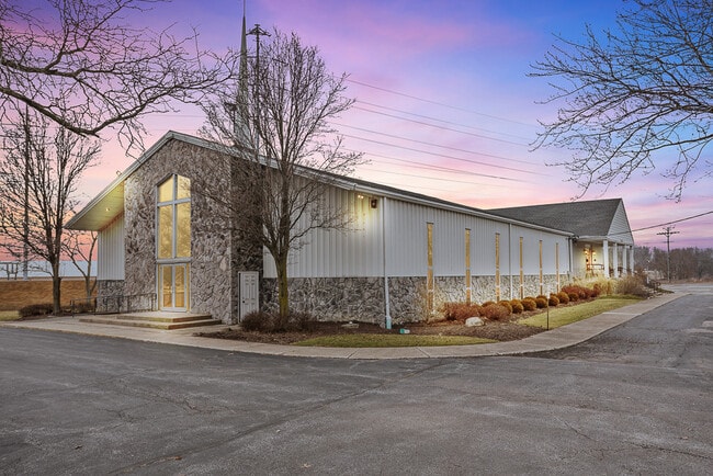
Property Record
16670 Fry Rd, Cleveland, OH 44130

NEARBY LISTINGS FOR SALE OR LEASE
-
-
View all Cleveland listings for sale on LoopNet.com
Property Detail
16670 Fry Rd
Cleveland-Elyria, OH
Lot Spl
371-24-012
S/L PCL A VOL 329 PG 32-33 FF 339.86 D 599.16 1.72AC OL SEC 7 2004S/R LOT SPLIT FROM C.E.I. CO. TO GREATER CLEVE. CHRISTIAN SCHOOL INC. MB371 PG24 MB329 PG32-33
Religious
Cuyahoga
X
Ohio
39035C0277E
18
2024
1.72 AC
2024
Southwest
178206
Cleveland
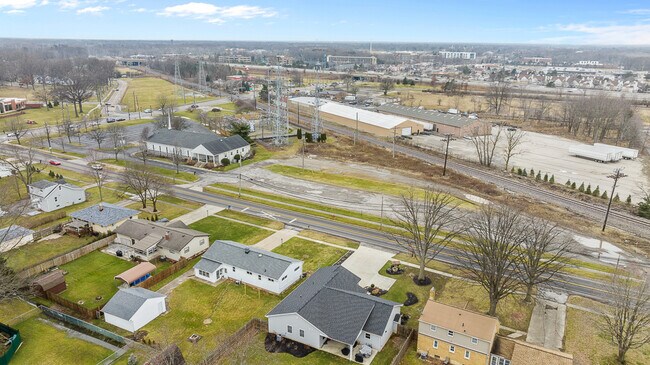
DEMOGRAPHICS near 16670 Fry Rd
1 Mile
3 Mile
5 Mile
2024 Total Population
6,241
67,202
176,899
2029 Population
6,046
65,233
172,055
Pop Growth 2024-2029
(3.12%)
(2.93%)
(2.74%)
Average Age
47
44
43
2024 Total Households
2,836
28,786
76,732
HH Growth 2024-2029
(3.42%)
(3.15%)
(2.94%)
Median Household Inc
$71,213
$66,302
$65,352
Avg Household Size
2.00
2.20
2.20
2024 Avg HH Vehicles
2.00
2.00
2.00
Median Home Value
$166,731
$166,891
$169,566
Median Year Built
1967
1963
1963
Nearby Places
Map Layers
Map Styles
 Street
 Aerial
- Restaurants
- Banks
- Shops
- Fitness
- Groceries
PUBLIC TRANSPORTATION
AIRPORT
Cleveland-Hopkins International
DRIVE
WALK
Distance
Cleveland-Hopkins International
13 min
6.3 mi
Freight Ports
Port of Toledo
DRIVE
WALK
Distance
Port of Toledo
128 min
105.0 mi
SALE & LEASE HISTORY
LISTING DATE
SALE/LEASE

Feb 29, 2024
For Sale
Nearby Properties
Address
Land Use
TOTAL SIZE
Lot Size
Zoning
Address
Land Use
TOTAL SIZE
Lot Size
Zoning
1,490,538 SF
19.29 AC
PF
Address
Land Use
TOTAL SIZE
Lot Size
Zoning
754.68 AC
GI
Address
Land Use
TOTAL SIZE
Lot Size
Zoning
526.33 AC
GI
Address
Land Use
TOTAL SIZE
Lot Size
Zoning
237,144 SF
2.12 AC
PG
Address
Land Use
TOTAL SIZE
Lot Size
Zoning
668,882 SF
41.27 AC
SC
Address
Land Use
TOTAL SIZE
Lot Size
Zoning
1,514 SF
23.65 AC
RSF-B
Address
Land Use
TOTAL SIZE
Lot Size
Zoning
208.22 AC
U5-A
Address
Land Use
TOTAL SIZE
Lot Size
Zoning
657,013 SF
48.88 AC
SI
Address
Land Use
TOTAL SIZE
Lot Size
Zoning
725,585 SF
76.92 AC
SF-A
Address
Land Use
TOTAL SIZE
Lot Size
Zoning
289,215 SF
20.56 AC
RSF-B
Address
Land Use
TOTAL SIZE
Lot Size
Zoning
Address
Land Use
TOTAL SIZE
Lot Size
Zoning
768,485 SF
14.53 AC
R1-A
Address
Land Use
TOTAL SIZE
Lot Size
Zoning
88.28 AC
U5-A
Address
Land Use
TOTAL SIZE
Lot Size
Zoning
244,717 SF
23.97 AC
RMF-1
Address
Land Use
TOTAL SIZE
Lot Size
Zoning
505,418 SF
33.99 AC
SC
Address
Land Use
TOTAL SIZE
Lot Size
Zoning
299,114 SF
23.65 AC
RSF-B
Address
Land Use
TOTAL SIZE
Lot Size
Zoning
126,000 SF
3.02 AC
PG
Address
Land Use
TOTAL SIZE
Lot Size
Zoning
309,231 SF
34.28 AC
Address
Land Use
TOTAL SIZE
Lot Size
Zoning
1,391,445 SF
136.05 AC
GI
Address
Land Use
TOTAL SIZE
Lot Size
Zoning
3.53 AC
SI
Address
Land Use
TOTAL SIZE
Lot Size
Zoning
364,000 SF
33.27 AC
U5-A
Address
Land Use
TOTAL SIZE
Lot Size
Zoning
174.94 AC
U5-A
Address
Land Use
TOTAL SIZE
Lot Size
Zoning
300,120 SF
20.18 AC
GI
Address
Land Use
TOTAL SIZE
Lot Size
Zoning
263,867 SF
59.28 AC
PF
Address
Land Use
TOTAL SIZE
Lot Size
Zoning
426.60 AC
PF
Address
Land Use
TOTAL SIZE
Lot Size
Zoning
166,104 SF
4.70 AC
CC
Address
Land Use
TOTAL SIZE
Lot Size
Zoning
24.55 AC
GI
Address
Land Use
TOTAL SIZE
Lot Size
Zoning
107,427 SF
30 AC
SF-A
Address
Land Use
TOTAL SIZE
Lot Size
Zoning
334,360 SF
8.22 AC
MF-HD
Address
Land Use
TOTAL SIZE
Lot Size
Zoning
263,926 SF
95.55 AC
GI
The World's #1 Commercial Real Estate Marketplace
Connect with us
© 2025 CoStar Group
The information above has been obtained from sources believed reliable. While we do not doubt its accuracy we have not verified it and make no guarantee, warranty or representation about it. It is your responsibility to independently confirm its accuracy and completeness. Any projections, opinions, assumptions, or estimates used are for example only and do not represent the current or future performance of the property. The value of this transaction to you depends on tax and other factors which should be evaluated by your tax, financial, and legal advisors. You and your advisors should conduct a careful, independent investigation of the property to determine to your satisfaction the suitability of the property for your needs.