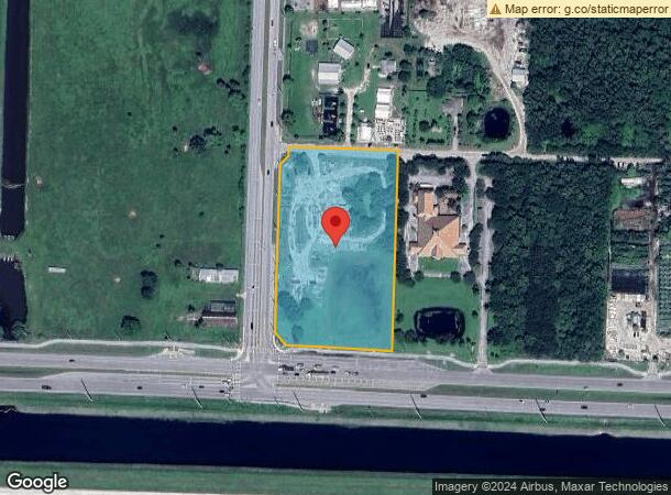
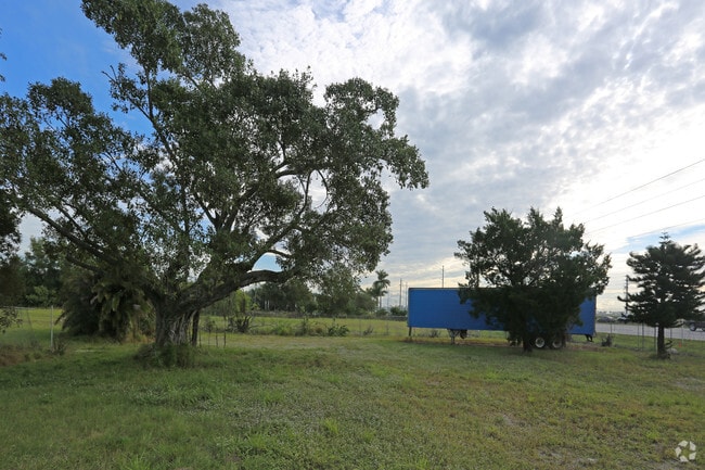
Property Record
16670 Rembrandt Rd, Loxahatchee, FL 33470

NEARBY LISTINGS FOR SALE OR LEASE
Property Detail
16670 Rembrandt Rd
South Florida
Acreage & Unrec
West Palm Beach-Boca Raton-Delray Beach, FL
36-43-40~ SLY 633.96 FT OF WLY 349.14 FT LYG N OF & ADJ TO SR 80 & E OF & ADJ TO SEMINOLE PRATT WHITNEY RD R/WS A/K/A TR A IN OR29549P412
00-40-43-36-00-000-7020
Palm Beach
Commercialacreage
Florida
2024
5.38 AC
2025
Palm Bch Cty Outlying
007851
DEMOGRAPHICS near 16670 Rembrandt Rd
1 Mile
3 Mile
5 Mile
2024 Total Population
807
14,479
55,164
2029 Population
815
14,827
56,742
Pop Growth 2024-2029
+ 0.99%
+ 2.40%
+ 2.86%
Average Age
42
40
40
2024 Total Households
258
4,609
18,719
HH Growth 2024-2029
0.00%
+ 1.48%
+ 2.08%
Median Household Inc
$122,158
$121,797
$102,031
Avg Household Size
2.90
3.00
2.80
2024 Avg HH Vehicles
2.00
2.00
2.00
Median Home Value
$671,428
$550,000
$433,639
Median Year Built
1991
1990
1991
Nearby Places
Map Layers
Map Styles
 Street
 Aerial
- Restaurants
- Banks
- Shops
- Fitness
- Groceries
PUBLIC TRANSPORTATION
AIRPORT
Palm Beach International
DRIVE
WALK
Distance
Palm Beach International
24 min
13.9 mi
Freight Ports
Port of Palm Beach
DRIVE
WALK
Distance
Port of Palm Beach
38 min
21.5 mi
SALE & LEASE HISTORY
LISTING DATE
SALE/LEASE

Jan 14, 2019
For Sale
Nearby Properties
Address
Land Use
TOTAL SIZE
Lot Size
Zoning
Address
Land Use
TOTAL SIZE
Lot Size
Zoning
190,294 SF
18.71 AC
PUD
Address
Land Use
TOTAL SIZE
Lot Size
Zoning
54,192 SF
74.82 AC
AR
Address
Land Use
TOTAL SIZE
Lot Size
Zoning
152,455 SF
33.77 AC
PUD
Address
Land Use
TOTAL SIZE
Lot Size
Zoning
122,559 SF
15 AC
PUD
Address
Land Use
TOTAL SIZE
Lot Size
Zoning
98,538 SF
2.45 AC
CL
Address
Land Use
TOTAL SIZE
Lot Size
Zoning
63,826 SF
8.22 AC
CL
Address
Land Use
TOTAL SIZE
Lot Size
Zoning
35,390 SF
631.36 AC
MUPD
Address
Land Use
TOTAL SIZE
Lot Size
Zoning
61,105 SF
32.10 AC
AR
Address
Land Use
TOTAL SIZE
Lot Size
Zoning
69,124 SF
29.91 AC
PO
Address
Land Use
TOTAL SIZE
Lot Size
Zoning
63,105 SF
51.62 AC
PUD
Address
Land Use
TOTAL SIZE
Lot Size
Zoning
294 SF
28.79 AC
PO
Address
Land Use
TOTAL SIZE
Lot Size
Zoning
11,453 SF
4.11 AC
PUD
Address
Land Use
TOTAL SIZE
Lot Size
Zoning
171.13 AC
PUD
Address
Land Use
TOTAL SIZE
Lot Size
Zoning
19,263 SF
2.44 AC
MUPD
Address
Land Use
TOTAL SIZE
Lot Size
Zoning
20,370 SF
3.44 AC
CL
Address
Land Use
TOTAL SIZE
Lot Size
Zoning
632.55 AC
STA/AR
Address
Land Use
TOTAL SIZE
Lot Size
Zoning
10,475 SF
2.37 AC
PUD
Address
Land Use
TOTAL SIZE
Lot Size
Zoning
629.21 AC
STA/AR
Address
Land Use
TOTAL SIZE
Lot Size
Zoning
6,120 SF
1.61 AC
MUPD
Address
Land Use
TOTAL SIZE
Lot Size
Zoning
4,947 SF
1.52 AC
MUPD
Address
Land Use
TOTAL SIZE
Lot Size
Zoning
1,680 SF
19.51 AC
CRE
Address
Land Use
TOTAL SIZE
Lot Size
Zoning
470.44 AC
STA/AR
Address
Land Use
TOTAL SIZE
Lot Size
Zoning
22,380 SF
5.90 AC
CL
Address
Land Use
TOTAL SIZE
Lot Size
Zoning
19,426 SF
4.93 AC
CC
Address
Land Use
TOTAL SIZE
Lot Size
Zoning
4,741 SF
1.40 AC
MUPD
Address
Land Use
TOTAL SIZE
Lot Size
Zoning
7,115 SF
2.42 AC
PUD
Address
Land Use
TOTAL SIZE
Lot Size
Zoning
7,334 SF
2.69 AC
PUD
Address
Land Use
TOTAL SIZE
Lot Size
Zoning
8,088 SF
2.90 AC
PUD
Address
Land Use
TOTAL SIZE
Lot Size
Zoning
6,496 SF
4.43 AC
PUD
Address
Land Use
TOTAL SIZE
Lot Size
Zoning
5,456 SF
6.25 AC
RROZD
The World's #1 Commercial Real Estate Marketplace
Connect with us
© 2026 CoStar Group
The information above has been obtained from sources believed reliable. While we do not doubt its accuracy we have not verified it and make no guarantee, warranty or representation about it. It is your responsibility to independently confirm its accuracy and completeness. Any projections, opinions, assumptions, or estimates used are for example only and do not represent the current or future performance of the property. The value of this transaction to you depends on tax and other factors which should be evaluated by your tax, financial, and legal advisors. You and your advisors should conduct a careful, independent investigation of the property to determine to your satisfaction the suitability of the property for your needs.