Property Record
1668 Brockman Mcclimon Rd, Greer, SC 29651

Save to a Folder
{{folder.Name}}
{{folder.ListingIds.length}} Properties
{{folder.ListingIds.length}} Property
Create a New Folder
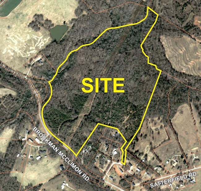
Property Detail
1668 Brockman Mcclimon Rd
Spartanburg, SC
E SIDE BROCKMAN MCCLIMON RD S OF BABE WOOD RD DB 39D-60 & 53B-572 & PB 100-387 DB 54L-321 & 322
5-41-00-020.00
SPARTANBURG
Agriculturalland
South Carolina
AE The base floodplain where base flood elevations are provided. AE Zones are now used on new format FIRMs instead of A1-A30 Zones.
61.68 AC
2024
Rt 101 Corridor
2025
Greenville/Spartanburg
023405
NEARBY LISTINGS FOR SALE OR LEASE
-
-
View all Greer listings for sale on LoopNet.com
DEMOGRAPHICS near 1668 Brockman Mcclimon Rd
1 mile
3 mile
5 mile
2025 Total Population
1,251
20,105
70,166
2030 Population
1,410
22,229
76,523
Pop Growth 2025-2030
+ 12.71%
+ 10.56%
+ 9.06%
Average Age
41
39
40
2025 Total Households
455
6,867
25,179
HH Growth 2025-2030
+ 12.75%
+ 10.86%
+ 9.25%
Median Household Inc
$103,896
$119,751
$113,373
Avg Household Size
2.70
2.90
2.70
2025 Avg HH Vehicles
2.00
2.00
2.00
Median Home Value
$366,489
$406,041
$390,797
Median Year Built
2004
2004
2003
Nearby Places
Map Layers
Map Styles
 Street
 Aerial
Layers
 Traffic
 Biking
Places
Listings with unknown addresses are not visible on the map
- Restaurants
- Banks
- Shops
- Fitness
- Groceries
PUBLIC TRANSPORTATION
AIRPORT
Greenville Spartanburg International
Drive
Walk
Distance
Greenville Spartanburg International
14 min
5.6 mi
Freight Ports
North Charleston Terminal
Drive
Walk
Distance
North Charleston Terminal
230 min
193.9 mi
SALE & LEASE HISTORY
LISTING DATE
SALE/LEASE

Sep 24, 2016
For Sale
Aug 31, 2018
For Sale
Nearby Properties
Address
Land Use
TOTAL SIZE
Lot Size
Zoning
Address
Land Use
TOTAL SIZE
Lot Size
Zoning
380,932 SF
30.39 AC
Address
Land Use
TOTAL SIZE
Lot Size
Zoning
301 AC
RS
Address
Land Use
TOTAL SIZE
Lot Size
Zoning
2.30 AC
I1
Address
Land Use
TOTAL SIZE
Lot Size
Zoning
1.70 AC
I1
Address
Land Use
TOTAL SIZE
Lot Size
Zoning
1,345 SF
115.58 AC
Address
Land Use
TOTAL SIZE
Lot Size
Zoning
34.33 AC
RS
Address
Land Use
TOTAL SIZE
Lot Size
Zoning
3,507 SF
8.78 AC
I1
Address
Land Use
TOTAL SIZE
Lot Size
Zoning
15.26 AC
Address
Land Use
TOTAL SIZE
Lot Size
Zoning
28.30 AC
RS
Address
Land Use
TOTAL SIZE
Lot Size
Zoning
3.24 AC
I1
Address
Land Use
TOTAL SIZE
Lot Size
Zoning
25.96 AC
RS
Address
Land Use
TOTAL SIZE
Lot Size
Zoning
49.81 AC
Address
Land Use
TOTAL SIZE
Lot Size
Zoning
12.80 AC
RS
Address
Land Use
TOTAL SIZE
Lot Size
Zoning
18.76 AC
RS
Address
Land Use
TOTAL SIZE
Lot Size
Zoning
8,543 SF
13.14 AC
Address
Land Use
TOTAL SIZE
Lot Size
Zoning
3.40 AC
RS
Address
Land Use
TOTAL SIZE
Lot Size
Zoning
3.09 AC
RS
Address
Land Use
TOTAL SIZE
Lot Size
Zoning
14,306 SF
3.64 AC
RS
Address
Land Use
TOTAL SIZE
Lot Size
Zoning
6.74 AC
I1
Address
Land Use
TOTAL SIZE
Lot Size
Zoning
1,518 SF
78.61 AC
Address
Land Use
TOTAL SIZE
Lot Size
Zoning
1,324 SF
9.80 AC
RS
Address
Land Use
TOTAL SIZE
Lot Size
Zoning
7,776 SF
29.90 AC
Address
Land Use
TOTAL SIZE
Lot Size
Zoning
6,874 SF
1.79 AC
Address
Land Use
TOTAL SIZE
Lot Size
Zoning
8.45 AC
RS
Address
Land Use
TOTAL SIZE
Lot Size
Zoning
7.53 AC
RS
Address
Land Use
TOTAL SIZE
Lot Size
Zoning
4,769 SF
0.60 AC
Address
Land Use
TOTAL SIZE
Lot Size
Zoning
3,495 SF
87 SF
Address
Land Use
TOTAL SIZE
Lot Size
Zoning
8.10 AC
RS
Address
Land Use
TOTAL SIZE
Lot Size
Zoning
7.90 AC
RS
Address
Land Use
TOTAL SIZE
Lot Size
Zoning
13,628 SF
8.80 AC
The World's #1 Commercial Real Estate Marketplace
Connect with us
© 2026 CoStar Group
The information above has been obtained from sources believed reliable. While we do not doubt its accuracy we have not verified it and make no guarantee, warranty or representation about it. It is your responsibility to independently confirm its accuracy and completeness. Any projections, opinions, assumptions, or estimates used are for example only and do not represent the current or future performance of the property. The value of this transaction to you depends on tax and other factors which should be evaluated by your tax, financial, and legal advisors. You and your advisors should conduct a careful, independent investigation of the property to determine to your satisfaction the suitability of the property for your needs.