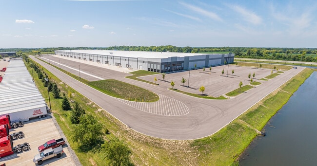
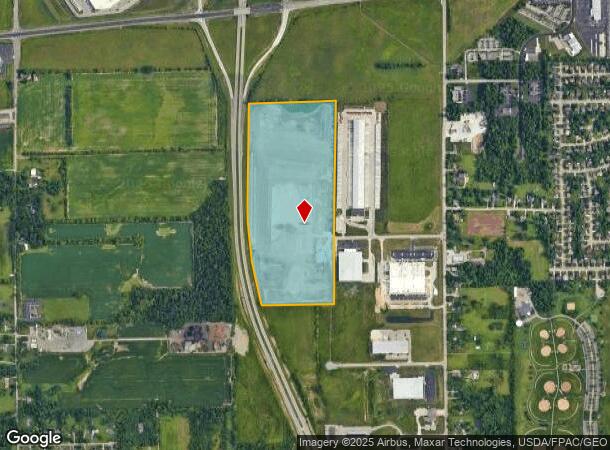
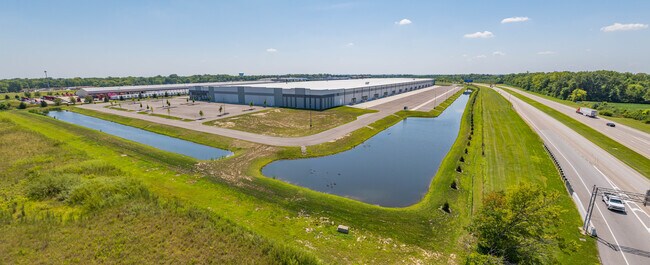
Property Record
1669 Capstone Way, Vandalia, OH 45377
Current Lease Availabilities
NEARBY LISTINGS FOR SALE OR LEASE
Property Detail
1669 Capstone Way
Dayton, OH
Dayton Sts Subd
B02-01013-0021
1 DAYTON STS SUBDIVISION 15 YR ABA 100% 2024-2038 FT 2039
Warehouse
Montgomery
0
Ohio
2025
56.40 AC
115012
North Dayton
730,000 SF
Cincinnati/Dayton
DEMOGRAPHICS near 1669 Capstone Way
1 Mile
3 Mile
5 Mile
2024 Total Population
1,333
19,148
69,824
2029 Population
1,310
18,796
68,933
Pop Growth 2024-2029
(1.73%)
(1.84%)
(1.28%)
Average Age
41
43
43
2024 Total Households
586
8,323
29,915
HH Growth 2024-2029
(1.71%)
(1.85%)
(1.27%)
Median Household Inc
$87,105
$83,344
$70,201
Avg Household Size
2.20
2.30
2.30
2024 Avg HH Vehicles
2.00
2.00
2.00
Median Home Value
$222,115
$237,302
$196,983
Median Year Built
1969
1970
1970
Nearby Places
Map Layers
Map Styles
 Street
 Aerial
- Restaurants
- Banks
- Shops
- Fitness
- Groceries
PUBLIC TRANSPORTATION
AIRPORT
James M Cox Dayton International
DRIVE
WALK
Distance
James M Cox Dayton International
8 min
2.5 mi
Freight Ports
Port of Toledo
DRIVE
WALK
Distance
Port of Toledo
171 min
146.5 mi
Nearby Properties
Address
Land Use
TOTAL SIZE
Lot Size
Zoning
Address
Land Use
TOTAL SIZE
Lot Size
Zoning
2,810,636 SF
79.21 AC
Address
Land Use
TOTAL SIZE
Lot Size
Zoning
1,841,033 SF
129.70 AC
Address
Land Use
TOTAL SIZE
Lot Size
Zoning
562,815 SF
41.46 AC
Address
Land Use
TOTAL SIZE
Lot Size
Zoning
551,408 SF
71 AC
Address
Land Use
TOTAL SIZE
Lot Size
Zoning
1,059,902 SF
56.13 AC
Address
Land Use
TOTAL SIZE
Lot Size
Zoning
678,154 SF
858.39 AC
Address
Land Use
TOTAL SIZE
Lot Size
Zoning
634,247 SF
86.18 AC
Address
Land Use
TOTAL SIZE
Lot Size
Zoning
834,238 SF
42.05 AC
Address
Land Use
TOTAL SIZE
Lot Size
Zoning
664,824 SF
1,128.84 AC
Address
Land Use
TOTAL SIZE
Lot Size
Zoning
37.86 AC
Address
Land Use
TOTAL SIZE
Lot Size
Zoning
597,314 SF
38.27 AC
Address
Land Use
TOTAL SIZE
Lot Size
Zoning
527,904 SF
75.77 AC
Address
Land Use
TOTAL SIZE
Lot Size
Zoning
730,000 SF
56.40 AC
Address
Land Use
TOTAL SIZE
Lot Size
Zoning
522,340 SF
36.59 AC
Address
Land Use
TOTAL SIZE
Lot Size
Zoning
45,980 SF
6.05 AC
Address
Land Use
TOTAL SIZE
Lot Size
Zoning
433,792 SF
34.46 AC
Address
Land Use
TOTAL SIZE
Lot Size
Zoning
12,660 SF
20.22 AC
Address
Land Use
TOTAL SIZE
Lot Size
Zoning
Address
Land Use
TOTAL SIZE
Lot Size
Zoning
92,192 SF
41.46 AC
Address
Land Use
TOTAL SIZE
Lot Size
Zoning
172,753 SF
23.76 AC
Address
Land Use
TOTAL SIZE
Lot Size
Zoning
200,716 SF
32.06 AC
Address
Land Use
TOTAL SIZE
Lot Size
Zoning
143,980 SF
35.40 AC
Address
Land Use
TOTAL SIZE
Lot Size
Zoning
222,799 SF
13.74 AC
Address
Land Use
TOTAL SIZE
Lot Size
Zoning
0.45 AC
Address
Land Use
TOTAL SIZE
Lot Size
Zoning
92,440 SF
3.01 AC
Address
Land Use
TOTAL SIZE
Lot Size
Zoning
76,156 SF
97.13 AC
Address
Land Use
TOTAL SIZE
Lot Size
Zoning
92,985 SF
14.50 AC
Address
Land Use
TOTAL SIZE
Lot Size
Zoning
Address
Land Use
TOTAL SIZE
Lot Size
Zoning
126,038 SF
13.78 AC
The World's #1 Commercial Real Estate Marketplace
Connect with us
© 2025 CoStar Group
The information above has been obtained from sources believed reliable. While we do not doubt its accuracy we have not verified it and make no guarantee, warranty or representation about it. It is your responsibility to independently confirm its accuracy and completeness. Any projections, opinions, assumptions, or estimates used are for example only and do not represent the current or future performance of the property. The value of this transaction to you depends on tax and other factors which should be evaluated by your tax, financial, and legal advisors. You and your advisors should conduct a careful, independent investigation of the property to determine to your satisfaction the suitability of the property for your needs.