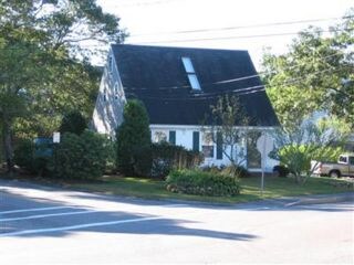
Property Record
167 Lovells Ln, Mashpee, MA 02649


Save to a Folder
{{folder.Name}}
{{folder.ListingIds.length}} Properties
{{folder.ListingIds.length}} Property
Create a New Folder
Property Detail
167 Lovells Ln
MASH-000044-000001A
BARNSTABLE
Taxexempt
Massachusetts
B and X Area of moderate flood hazard, usually the area between the limits of the 100-year and 500-year floods.
13.77 AC
0
Cape Cod
2025
Other Market Areas
015002
Barnstable Town, MA
NEARBY LISTINGS FOR SALE OR LEASE
-
-
View all Mashpee listings for sale on LoopNet.com
DEMOGRAPHICS near 167 Lovells Ln
1 mile
3 mile
5 mile
2025 Total Population
1,632
21,479
43,847
2030 Population
1,570
20,905
42,864
Pop Growth 2025-2030
(3.80%)
(2.67%)
(2.24%)
Average Age
49
48
48
2025 Total Households
665
8,883
18,092
HH Growth 2025-2030
(4.21%)
(2.74%)
(2.34%)
Median Household Inc
$109,568
$114,285
$109,040
Avg Household Size
2.40
2.40
2.30
2025 Avg HH Vehicles
2.00
2.00
2.00
Median Home Value
$734,210
$690,990
$665,801
Median Year Built
1982
1983
1982
Nearby Places
Map Layers
Map Styles
 Street
 Aerial
Layers
 Traffic
 Biking
Places
Listings with unknown addresses are not visible on the map
- Restaurants
- Banks
- Shops
- Fitness
- Groceries
PUBLIC TRANSPORTATION
AIRPORT
Martha's Vineyard
Drive
Walk
Distance
Martha's Vineyard
91 min
30.0 mi
Freight Ports
Port of New Bedford Harbor
Drive
Walk
Distance
Port of New Bedford Harbor
64 min
42.9 mi
SALE & LEASE HISTORY
LISTING DATE
SALE/LEASE

Mar 18, 2019
For Sale
Nearby Properties
Address
Land Use
TOTAL SIZE
Lot Size
Zoning
Address
Land Use
TOTAL SIZE
Lot Size
Zoning
12,713 SF
29.28 AC
C1
Address
Land Use
TOTAL SIZE
Lot Size
Zoning
10.94 AC
R3
Address
Land Use
TOTAL SIZE
Lot Size
Zoning
181,756 SF
135.43 AC
R5
Address
Land Use
TOTAL SIZE
Lot Size
Zoning
9 AC
C1
Address
Land Use
TOTAL SIZE
Lot Size
Zoning
2,295.68 AC
BUSINE
Address
Land Use
TOTAL SIZE
Lot Size
Zoning
15.10 AC
C1
Address
Land Use
TOTAL SIZE
Lot Size
Zoning
24.40 AC
R3
Address
Land Use
TOTAL SIZE
Lot Size
Zoning
65,930 SF
3.97 AC
C1
Address
Land Use
TOTAL SIZE
Lot Size
Zoning
24.50 AC
C2
Address
Land Use
TOTAL SIZE
Lot Size
Zoning
27.80 AC
R3
Address
Land Use
TOTAL SIZE
Lot Size
Zoning
13.30 AC
I1
Address
Land Use
TOTAL SIZE
Lot Size
Zoning
41,386 SF
7.59 AC
AGA
Address
Land Use
TOTAL SIZE
Lot Size
Zoning
8,544 SF
20.31 AC
R3
Address
Land Use
TOTAL SIZE
Lot Size
Zoning
6.27 AC
R3
Address
Land Use
TOTAL SIZE
Lot Size
Zoning
8,910 SF
31.84 AC
R5
Address
Land Use
TOTAL SIZE
Lot Size
Zoning
31,520 SF
3.89 AC
I1
Address
Land Use
TOTAL SIZE
Lot Size
Zoning
Address
Land Use
TOTAL SIZE
Lot Size
Zoning
158.42 AC
R
Address
Land Use
TOTAL SIZE
Lot Size
Zoning
5.13 AC
Address
Land Use
TOTAL SIZE
Lot Size
Zoning
229.61 AC
R3
Address
Land Use
TOTAL SIZE
Lot Size
Zoning
250.40 AC
R5
Address
Land Use
TOTAL SIZE
Lot Size
Zoning
33.20 AC
R5
Address
Land Use
TOTAL SIZE
Lot Size
Zoning
21,396 SF
1.90 AC
C1
Address
Land Use
TOTAL SIZE
Lot Size
Zoning
3.37 AC
C1
Address
Land Use
TOTAL SIZE
Lot Size
Zoning
36,419 SF
7.29 AC
R3
Address
Land Use
TOTAL SIZE
Lot Size
Zoning
3.37 AC
Address
Land Use
TOTAL SIZE
Lot Size
Zoning
183.73 AC
R5
Address
Land Use
TOTAL SIZE
Lot Size
Zoning
47,421 SF
4.32 AC
I1
Address
Land Use
TOTAL SIZE
Lot Size
Zoning
8 AC
R5
Address
Land Use
TOTAL SIZE
Lot Size
Zoning
65.40 AC
R5
The World's #1 Commercial Real Estate Marketplace
Connect with us
© 2026 CoStar Group
The information above has been obtained from sources believed reliable. While we do not doubt its accuracy we have not verified it and make no guarantee, warranty or representation about it. It is your responsibility to independently confirm its accuracy and completeness. Any projections, opinions, assumptions, or estimates used are for example only and do not represent the current or future performance of the property. The value of this transaction to you depends on tax and other factors which should be evaluated by your tax, financial, and legal advisors. You and your advisors should conduct a careful, independent investigation of the property to determine to your satisfaction the suitability of the property for your needs.