Property Record
167 Nc Highway 49 N, Ramseur, NC 27316
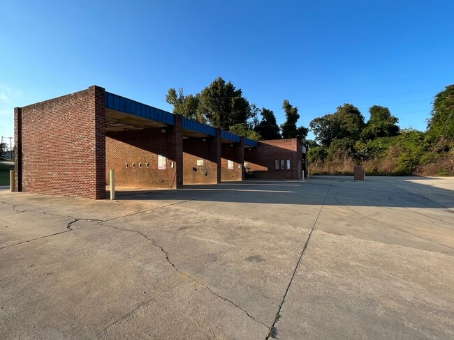
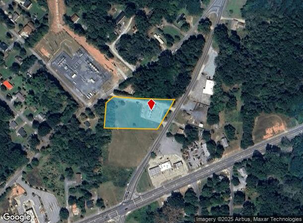
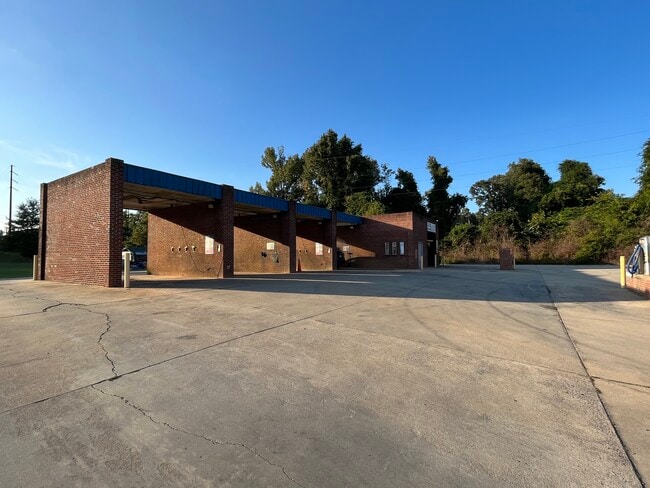
This Property Is For Sale
NEARBY LISTINGS FOR SALE OR LEASE
-
-
View all Ramseur listings for sale on LoopNet.com
Property Detail
167 Nc Highway 49 N
8702-75-7488
R49;W R2488 S
Carwashselfserve
Randolph
X
North Carolina
3710870200J
1.76 AC
2025
NE Randolph County
2025
Greensboro/Winston-Salem
031001
Greensboro-High Point, NC
2,300 SF
DEMOGRAPHICS near 167 Nc Highway 49 N
1 Mile
3 Mile
5 Mile
2024 Total Population
1,654
6,272
12,102
2029 Population
1,688
6,466
12,452
Pop Growth 2024-2029
+ 2.06%
+ 3.09%
+ 2.89%
Average Age
42
41
40
2024 Total Households
637
2,437
4,691
HH Growth 2024-2029
+ 2.20%
+ 3.16%
+ 2.94%
Median Household Inc
$44,726
$49,173
$56,271
Avg Household Size
2.50
2.50
2.50
2024 Avg HH Vehicles
2.00
2.00
2.00
Median Home Value
$164,784
$171,639
$187,092
Median Year Built
1974
1977
1983
Nearby Places
Map Layers
Map Styles
 Street
 Aerial
- Restaurants
- Banks
- Shops
- Fitness
- Groceries
PUBLIC TRANSPORTATION
AIRPORT
Piedmont Triad International
DRIVE
WALK
Distance
Piedmont Triad International
52 min
36.6 mi
Freight Ports
Port of Wilmington
DRIVE
WALK
Distance
Port of Wilmington
227 min
164.4 mi
Nearby Properties
Address
Land Use
TOTAL SIZE
Lot Size
Zoning
Address
Land Use
TOTAL SIZE
Lot Size
Zoning
1,388 SF
75.55 AC
RR
Address
Land Use
TOTAL SIZE
Lot Size
Zoning
2,720 SF
138.57 AC
NR
Address
Land Use
TOTAL SIZE
Lot Size
Zoning
39,739 SF
10.60 AC
RA-20
Address
Land Use
TOTAL SIZE
Lot Size
Zoning
4.97 AC
I&C
Address
Land Use
TOTAL SIZE
Lot Size
Zoning
72,000 SF
42.04 AC
LI
Address
Land Use
TOTAL SIZE
Lot Size
Zoning
43,348 SF
39.10 AC
RR
Address
Land Use
TOTAL SIZE
Lot Size
Zoning
1.20 AC
TC
Address
Land Use
TOTAL SIZE
Lot Size
Zoning
38,612 SF
3.83 AC
B
Address
Land Use
TOTAL SIZE
Lot Size
Zoning
38,612 SF
3.76 AC
B
Address
Land Use
TOTAL SIZE
Lot Size
Zoning
11,620 SF
3.61 AC
RA
Address
Land Use
TOTAL SIZE
Lot Size
Zoning
54,690 SF
11.78 AC
I
Address
Land Use
TOTAL SIZE
Lot Size
Zoning
6,288 SF
4.30 AC
RA-16
Address
Land Use
TOTAL SIZE
Lot Size
Zoning
33,699 SF
15.01 AC
HC
Address
Land Use
TOTAL SIZE
Lot Size
Zoning
4,752 SF
4.30 AC
B
Address
Land Use
TOTAL SIZE
Lot Size
Zoning
66,166 SF
72.25 AC
I
Address
Land Use
TOTAL SIZE
Lot Size
Zoning
5,336 SF
1.95 AC
B
Address
Land Use
TOTAL SIZE
Lot Size
Zoning
10,806 SF
2.72 AC
B
Address
Land Use
TOTAL SIZE
Lot Size
Zoning
17,321 SF
6.21 AC
TC
Address
Land Use
TOTAL SIZE
Lot Size
Zoning
23,960 SF
12.92 AC
I
Address
Land Use
TOTAL SIZE
Lot Size
Zoning
20,720 SF
1.57 AC
I&C
Address
Land Use
TOTAL SIZE
Lot Size
Zoning
13,460 SF
0.85 AC
I&C
Address
Land Use
TOTAL SIZE
Lot Size
Zoning
3,938 SF
2.26 AC
B
Address
Land Use
TOTAL SIZE
Lot Size
Zoning
4,800 SF
97.60 AC
RA
Address
Land Use
TOTAL SIZE
Lot Size
Zoning
9,360 SF
10.03 AC
LI-CD
Address
Land Use
TOTAL SIZE
Lot Size
Zoning
43,848 SF
17.21 AC
I
Address
Land Use
TOTAL SIZE
Lot Size
Zoning
8,660 SF
0.20 AC
I&C
Address
Land Use
TOTAL SIZE
Lot Size
Zoning
9,842 SF
0.87 AC
NB
Address
Land Use
TOTAL SIZE
Lot Size
Zoning
6,912 SF
10.47 AC
HC
Address
Land Use
TOTAL SIZE
Lot Size
Zoning
25.81 AC
RM
Address
Land Use
TOTAL SIZE
Lot Size
Zoning
9,000 SF
3.37 AC
B
The World's #1 Commercial Real Estate Marketplace
Connect with us
© 2025 CoStar Group
The information above has been obtained from sources believed reliable. While we do not doubt its accuracy we have not verified it and make no guarantee, warranty or representation about it. It is your responsibility to independently confirm its accuracy and completeness. Any projections, opinions, assumptions, or estimates used are for example only and do not represent the current or future performance of the property. The value of this transaction to you depends on tax and other factors which should be evaluated by your tax, financial, and legal advisors. You and your advisors should conduct a careful, independent investigation of the property to determine to your satisfaction the suitability of the property for your needs.