Property Record
167 Nomad Dr, Plattsburgh, NY 12901
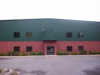


Property Detail
167 Nomad Dr
094200-246-000-0003-001-000-0000
CLINTON
Warehouse
New York
A1
1.000
B and X Area of moderate flood hazard, usually the area between the limits of the 100-year and 500-year floods.
89.34 AC
2025
Plattsburgh
2025
Other Market Areas
102100
Plattsburgh, NY
80,936 SF
NEARBY LISTINGS FOR SALE OR LEASE
DEMOGRAPHICS near 167 Nomad Dr
1 mile
3 mile
5 mile
2025 Total Population
745
10,764
28,281
2030 Population
744
10,625
27,872
Pop Growth 2025-2030
(0.13%)
(1.29%)
(1.45%)
Average Age
42
43
42
2025 Total Households
297
4,812
13,048
HH Growth 2025-2030
(0.34%)
(1.33%)
(1.48%)
Median Household Inc
$46,979
$55,352
$55,813
Avg Household Size
2.50
2.20
2.10
2025 Avg HH Vehicles
2.00
1.00
2.00
Median Home Value
$90,624
$159,060
$191,556
Median Year Built
1978
1976
1971
Nearby Places
Map Layers
Map Styles
 Street
 Aerial
Transit
 Traffic
 Biking
Places
Listings with unknown addresses are not visible on the map
- Restaurants
- Banks
- Shops
- Fitness
- Groceries
PUBLIC TRANSPORTATION
COMMUTER RAIL
Drive
Walk
Distance
11 min
5.4 mi
AIRPORT
Plattsburgh International
Drive
Walk
Distance
Plattsburgh International
10 min
4.1 mi
Patrick Leahy Burlington International
Drive
Walk
Distance
Patrick Leahy Burlington International
75 min
35.7 mi
Nearby Properties
Address
Land Use
TOTAL SIZE
Lot Size
Zoning
Address
Land Use
TOTAL SIZE
Lot Size
Zoning
800 SF
776.23 AC
A1
Address
Land Use
TOTAL SIZE
Lot Size
Zoning
121,465 SF
92 AC
R-2
Address
Land Use
TOTAL SIZE
Lot Size
Zoning
564.20 AC
A1
Address
Land Use
TOTAL SIZE
Lot Size
Zoning
35,562 SF
204.40 AC
LC_OS
Address
Land Use
TOTAL SIZE
Lot Size
Zoning
167 AC
02 - SINGL
Address
Land Use
TOTAL SIZE
Lot Size
Zoning
117,847 SF
47.30 AC
00
Address
Land Use
TOTAL SIZE
Lot Size
Zoning
243,951 SF
21 AC
06 - INDUS
Address
Land Use
TOTAL SIZE
Lot Size
Zoning
218,230 SF
38.92 AC
I
Address
Land Use
TOTAL SIZE
Lot Size
Zoning
4,992 SF
13.20 AC
03 - MULTI
Address
Land Use
TOTAL SIZE
Lot Size
Zoning
229,741 SF
10.90 AC
06 - INDUS
Address
Land Use
TOTAL SIZE
Lot Size
Zoning
52,236 SF
9.14 AC
07 - MIXED
Address
Land Use
TOTAL SIZE
Lot Size
Zoning
131,093 SF
5.84 AC
I
Address
Land Use
TOTAL SIZE
Lot Size
Zoning
73,724 SF
17.30 AC
05 - COMME
Address
Land Use
TOTAL SIZE
Lot Size
Zoning
76,900 SF
6.90 AC
03 - MULTI
Address
Land Use
TOTAL SIZE
Lot Size
Zoning
45,887 SF
7.66 AC
07 - MIXED
Address
Land Use
TOTAL SIZE
Lot Size
Zoning
1,464 SF
31.70 AC
R-5
Address
Land Use
TOTAL SIZE
Lot Size
Zoning
22,080 SF
5.53 AC
A1
Address
Land Use
TOTAL SIZE
Lot Size
Zoning
68,264 SF
2.64 AC
03 - MULTI
Address
Land Use
TOTAL SIZE
Lot Size
Zoning
114,712 SF
9.72 AC
A2
Address
Land Use
TOTAL SIZE
Lot Size
Zoning
54,987 SF
24.30 AC
NC
Address
Land Use
TOTAL SIZE
Lot Size
Zoning
33,075 SF
4.90 AC
03 - MULTI
Address
Land Use
TOTAL SIZE
Lot Size
Zoning
9,422 SF
5 AC
03 - MULTI
Address
Land Use
TOTAL SIZE
Lot Size
Zoning
3.77 AC
08 - GOVER
Address
Land Use
TOTAL SIZE
Lot Size
Zoning
7,540 SF
10.70 AC
03 - MULTI
Address
Land Use
TOTAL SIZE
Lot Size
Zoning
40,926 SF
27.50 AC
C
Address
Land Use
TOTAL SIZE
Lot Size
Zoning
5,856 SF
4.94 AC
03 - MULTI
Address
Land Use
TOTAL SIZE
Lot Size
Zoning
10,992 SF
4.22 AC
07 - MIXED
Address
Land Use
TOTAL SIZE
Lot Size
Zoning
17,160 SF
6.33 AC
I
Address
Land Use
TOTAL SIZE
Lot Size
Zoning
60,693 SF
9.40 AC
A1
Address
Land Use
TOTAL SIZE
Lot Size
Zoning
101,505 SF
6.16 AC
A2
The World's #1 Commercial Real Estate Marketplace
Connect with us
© 2026 CoStar Group
The information above has been obtained from sources believed reliable. While we do not doubt its accuracy we have not verified it and make no guarantee, warranty or representation about it. It is your responsibility to independently confirm its accuracy and completeness. Any projections, opinions, assumptions, or estimates used are for example only and do not represent the current or future performance of the property. The value of this transaction to you depends on tax and other factors which should be evaluated by your tax, financial, and legal advisors. You and your advisors should conduct a careful, independent investigation of the property to determine to your satisfaction the suitability of the property for your needs.