Property Record
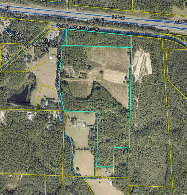
167 Peck Cawthon Rd, Defuniak Springs, FL 32435
NEARBY LISTINGS FOR SALE OR LEASE
Property Detail
167 Peck Cawthon Rd
10-2N-19-18000-002-0000
A PARCEL OF LAND SITUATED IN THE SW1/4 OF SEC 3-2N-19W DESC AS FOLLOWS: BEG AT SE/C OF SW1/4, N 88 DEG 1210W ALG S LINE OF SEC 3 720.99FT, S 38 DEG 3535W 423.59FT, N 88 DEG 0337W 449.17FT, N 04 DEG 3814E 338.41FT, S 88 DEG 1503E 80.30FT, N 01 DEG 491
Vacantlandnec
Walton
A
Florida
12131C0260G
30
2025
55.85 AC
2025
Florida Panhandle Area
950305
Other Market Areas
4,092 SF
Crestview-Fort Walton Beach-Destin, FL
DEMOGRAPHICS near 167 Peck Cawthon Rd
1 Mile
3 Mile
5 Mile
2024 Total Population
100
4,162
9,987
2029 Population
106
4,415
10,593
Pop Growth 2024-2029
+ 6.00%
+ 6.08%
+ 6.07%
Average Age
40
39
38
2024 Total Households
37
1,542
3,379
HH Growth 2024-2029
+ 5.41%
+ 4.86%
+ 5.03%
Median Household Inc
$74,999
$49,795
$49,374
Avg Household Size
2.50
2.40
2.50
2024 Avg HH Vehicles
2.00
2.00
2.00
Median Home Value
$241,666
$175,871
$182,030
Median Year Built
1996
1987
1993
Nearby Places
- Restaurants
- Banks
- Shops
- Fitness
- Groceries
PUBLIC TRANSPORTATION
AIRPORT
Eglin AFB/Destin-Ft Walton Beach
DRIVE
WALK
Distance
Eglin AFB/Destin-Ft Walton Beach
67 min
39.6 mi
Freight Ports
Port of Panama City
DRIVE
WALK
Distance
Port of Panama City
77 min
56.1 mi
Nearby Properties
Address
Land Use
TOTAL SIZE
Lot Size
Zoning
Address
Land Use
TOTAL SIZE
Lot Size
Zoning
174,929 SF
9.32 AC
HD1
Address
Land Use
TOTAL SIZE
Lot Size
Zoning
41,056 SF
2.22 AC
3310
Address
Land Use
TOTAL SIZE
Lot Size
Zoning
96,057 SF
10.37 AC
W END
Address
Land Use
TOTAL SIZE
Lot Size
Zoning
54,534 SF
7.33 AC
MUNI
Address
Land Use
TOTAL SIZE
Lot Size
Zoning
160,339 SF
19.76 AC
3310
Address
Land Use
TOTAL SIZE
Lot Size
Zoning
37,731 SF
15.96 AC
Address
Land Use
TOTAL SIZE
Lot Size
Zoning
53,201 SF
14.45 AC
Address
Land Use
TOTAL SIZE
Lot Size
Zoning
101,840 SF
11.04 AC
3310
Address
Land Use
TOTAL SIZE
Lot Size
Zoning
126,076 SF
11.38 AC
3310
Address
Land Use
TOTAL SIZE
Lot Size
Zoning
10,655 SF
163.72 AC
MUNI
Address
Land Use
TOTAL SIZE
Lot Size
Zoning
3,729 SF
98.46 AC
MUNI
Address
Land Use
TOTAL SIZE
Lot Size
Zoning
109,921 SF
2.25 AC
Address
Land Use
TOTAL SIZE
Lot Size
Zoning
52,428 SF
4.66 AC
3310
Address
Land Use
TOTAL SIZE
Lot Size
Zoning
68,153 SF
9.65 AC
3310
Address
Land Use
TOTAL SIZE
Lot Size
Zoning
61,948 SF
9.26 AC
3310
Address
Land Use
TOTAL SIZE
Lot Size
Zoning
15,264 SF
3.24 AC
3310
Address
Land Use
TOTAL SIZE
Lot Size
Zoning
15,587 SF
5.54 AC
Address
Land Use
TOTAL SIZE
Lot Size
Zoning
5,951 SF
1.64 AC
3310
Address
Land Use
TOTAL SIZE
Lot Size
Zoning
48,394 SF
8.79 AC
3310
Address
Land Use
TOTAL SIZE
Lot Size
Zoning
Address
Land Use
TOTAL SIZE
Lot Size
Zoning
70,200 SF
5.25 AC
3310
Address
Land Use
TOTAL SIZE
Lot Size
Zoning
13,793 SF
2.80 AC
3310
Address
Land Use
TOTAL SIZE
Lot Size
Zoning
23,674 SF
12.03 AC
3310
Address
Land Use
TOTAL SIZE
Lot Size
Zoning
32,375 SF
6.46 AC
HWY90
Address
Land Use
TOTAL SIZE
Lot Size
Zoning
17,310 SF
13.26 AC
3310
Address
Land Use
TOTAL SIZE
Lot Size
Zoning
35,967 SF
4.11 AC
Address
Land Use
TOTAL SIZE
Lot Size
Zoning
14,525 SF
0.90 AC
HWY90
Address
Land Use
TOTAL SIZE
Lot Size
Zoning
17,376 SF
79.90 AC
HD1
Address
Land Use
TOTAL SIZE
Lot Size
Zoning
446.50 AC
3310
Address
Land Use
TOTAL SIZE
Lot Size
Zoning
5,245 SF
1.45 AC
3310
The World's #1 Commercial Real Estate Marketplace
Connect with us
© 2025 CoStar Group
The information above has been obtained from sources believed reliable. While we do not doubt its accuracy we have not verified it and make no guarantee, warranty or representation about it. It is your responsibility to independently confirm its accuracy and completeness. Any projections, opinions, assumptions, or estimates used are for example only and do not represent the current or future performance of the property. The value of this transaction to you depends on tax and other factors which should be evaluated by your tax, financial, and legal advisors. You and your advisors should conduct a careful, independent investigation of the property to determine to your satisfaction the suitability of the property for your needs.