Property Record
1670 Berne Altamont Rd, Altamont, NY 12009
NEARBY LISTINGS FOR SALE OR LEASE
-
-
View all Altamont listings for sale on LoopNet.com
Property Detail
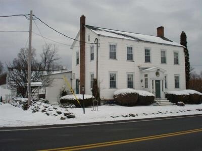
1670 Berne Altamont Rd
013200-047-000-0001-030-000-0000
1670 BERNE ALTAMONT ROAD
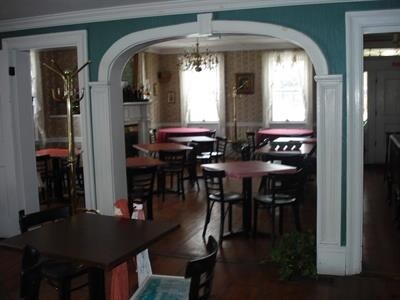
Restaurantbuilding
Albany
X
New York
36001C0140D
30.000
2025
4.67 AC
2024
W Outer Albany County
014700
Albany/Schenectady/Troy
4,514 SF
Albany-Schenectady-Troy, NY
DEMOGRAPHICS near 1670 Berne Altamont Rd
1 Mile
3 Mile
5 Mile
2024 Total Population
130
2,878
7,234
2029 Population
126
2,823
7,136
Pop Growth 2024-2029
(3.08%)
(1.91%)
(1.35%)
Average Age
45
44
44
2024 Total Households
53
1,166
2,949
HH Growth 2024-2029
(3.77%)
(1.97%)
(1.39%)
Median Household Inc
$108,654
$96,809
$92,254
Avg Household Size
2.50
2.50
2.40
2024 Avg HH Vehicles
2.00
2.00
2.00
Median Home Value
$307,143
$290,028
$292,403
Median Year Built
1975
1971
1969
Nearby Places
- Restaurants
- Banks
- Shops
- Fitness
- Groceries
PUBLIC TRANSPORTATION
AIRPORT
Albany International
DRIVE
WALK
Distance
Albany International
38 min
20.8 mi
Freight Ports
Albany, NY Port
DRIVE
WALK
Distance
Albany, NY Port
39 min
22.0 mi
Nearby Properties
Address
Land Use
TOTAL SIZE
Lot Size
Zoning
Address
Land Use
TOTAL SIZE
Lot Size
Zoning
4,600 SF
30.70 AC
R10
Address
Land Use
TOTAL SIZE
Lot Size
Zoning
800 SF
86.03 AC
RA5
Address
Land Use
TOTAL SIZE
Lot Size
Zoning
40,438 SF
11.10 AC
R10
Address
Land Use
TOTAL SIZE
Lot Size
Zoning
48,612 SF
14.40 AC
RA5
Address
Land Use
TOTAL SIZE
Lot Size
Zoning
8,670 SF
94.40 AC
RA5
Address
Land Use
TOTAL SIZE
Lot Size
Zoning
15,472 SF
42.60 AC
RA5
Address
Land Use
TOTAL SIZE
Lot Size
Zoning
10,166 SF
1.40 AC
R10
Address
Land Use
TOTAL SIZE
Lot Size
Zoning
6,944 SF
6.20 AC
R10M
Address
Land Use
TOTAL SIZE
Lot Size
Zoning
8,725 SF
1.30 AC
R10
Address
Land Use
TOTAL SIZE
Lot Size
Zoning
3,904 SF
50 AC
Address
Land Use
TOTAL SIZE
Lot Size
Zoning
3,015 SF
0.78 AC
GB
Address
Land Use
TOTAL SIZE
Lot Size
Zoning
140.70 AC
RA5
Address
Land Use
TOTAL SIZE
Lot Size
Zoning
4,671 SF
4 AC
R20
Address
Land Use
TOTAL SIZE
Lot Size
Zoning
303.20 AC
02 - SINGL
Address
Land Use
TOTAL SIZE
Lot Size
Zoning
6,260 SF
0.33 AC
LB
Address
Land Use
TOTAL SIZE
Lot Size
Zoning
10,563 SF
0.56 AC
GB
Address
Land Use
TOTAL SIZE
Lot Size
Zoning
4,128 SF
28.70 AC
RA5
Address
Land Use
TOTAL SIZE
Lot Size
Zoning
5,975 SF
0.79 AC
R10
Address
Land Use
TOTAL SIZE
Lot Size
Zoning
10,140 SF
1.40 AC
LI
Address
Land Use
TOTAL SIZE
Lot Size
Zoning
5,600 SF
1.10 AC
GB
Address
Land Use
TOTAL SIZE
Lot Size
Zoning
840 SF
17.01 AC
Address
Land Use
TOTAL SIZE
Lot Size
Zoning
798 SF
9.80 AC
RA5
Address
Land Use
TOTAL SIZE
Lot Size
Zoning
9,788 SF
0.84 AC
GB
Address
Land Use
TOTAL SIZE
Lot Size
Zoning
6,748 SF
0.75 AC
GB
Address
Land Use
TOTAL SIZE
Lot Size
Zoning
6,096 SF
0.34 AC
GB
Address
Land Use
TOTAL SIZE
Lot Size
Zoning
5,778 SF
0.92 AC
Address
Land Use
TOTAL SIZE
Lot Size
Zoning
840 SF
44.80 AC
Address
Land Use
TOTAL SIZE
Lot Size
Zoning
6,952 SF
10 AC
MDR
Address
Land Use
TOTAL SIZE
Lot Size
Zoning
4,430 SF
1.40 AC
Address
Land Use
TOTAL SIZE
Lot Size
Zoning
4,778 SF
0.21 AC
GB
The World's #1 Commercial Real Estate Marketplace
Connect with us
© 2025 CoStar Group
The information above has been obtained from sources believed reliable. While we do not doubt its accuracy we have not verified it and make no guarantee, warranty or representation about it. It is your responsibility to independently confirm its accuracy and completeness. Any projections, opinions, assumptions, or estimates used are for example only and do not represent the current or future performance of the property. The value of this transaction to you depends on tax and other factors which should be evaluated by your tax, financial, and legal advisors. You and your advisors should conduct a careful, independent investigation of the property to determine to your satisfaction the suitability of the property for your needs.