Property Record
1670 Mckendree Church Rd, Lawrenceville, GA 30043
Current Lease Availabilities
NEARBY LISTINGS FOR SALE OR LEASE
Property Detail
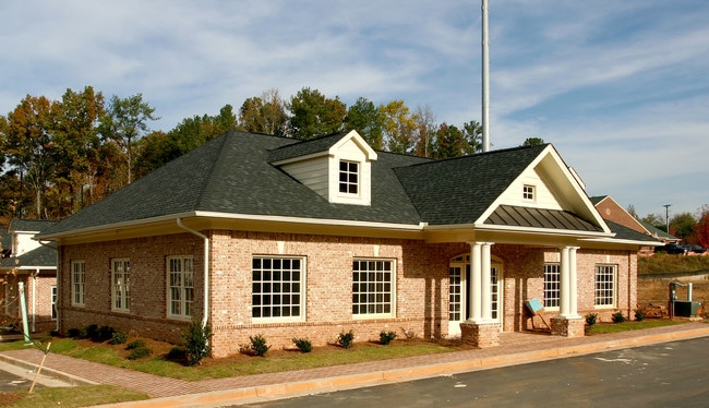
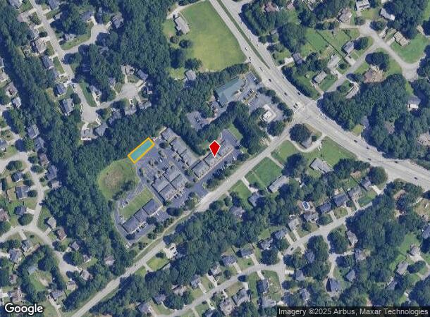
1670 Mckendree Church Rd
Atlanta-Sandy Springs-Roswell, GA
Mckendree Commons
7-070-615
BLDG 500 MCKENDREE COMMONS
Commercialacreage
Gwinnett
X
Georgia
13135C0058F
70
2025
0.12 AC
2025
Duluth/Suwanee/Buford
050553
Atlanta
DEMOGRAPHICS near 1670 Mckendree Church Rd
1 Mile
3 Mile
5 Mile
2024 Total Population
11,027
76,611
210,558
2029 Population
11,450
79,767
219,889
Pop Growth 2024-2029
+ 3.84%
+ 4.12%
+ 4.43%
Average Age
39
38
37
2024 Total Households
3,547
26,075
71,727
HH Growth 2024-2029
+ 3.92%
+ 4.23%
+ 4.60%
Median Household Inc
$91,704
$78,946
$74,344
Avg Household Size
3.10
2.90
2.90
2024 Avg HH Vehicles
2.00
2.00
2.00
Median Home Value
$280,750
$295,266
$296,269
Median Year Built
1991
1994
1995
Nearby Places
- Restaurants
- Banks
- Shops
- Fitness
- Groceries
PUBLIC TRANSPORTATION
AIRPORT
Hartsfield - Jackson Atlanta International
DRIVE
WALK
Distance
Hartsfield - Jackson Atlanta International
55 min
40.0 mi
Nearby Properties
Address
Land Use
TOTAL SIZE
Lot Size
Zoning
Address
Land Use
TOTAL SIZE
Lot Size
Zoning
1,276,197 SF
91.78 AC
OI
Address
Land Use
TOTAL SIZE
Lot Size
Zoning
939,709 SF
159.36 AC
RS180
Address
Land Use
TOTAL SIZE
Lot Size
Zoning
850,292 SF
70.76 AC
HM
Address
Land Use
TOTAL SIZE
Lot Size
Zoning
1,588,972 SF
112.95 AC
C2
Address
Land Use
TOTAL SIZE
Lot Size
Zoning
275,917 SF
13.34 AC
BG
Address
Land Use
TOTAL SIZE
Lot Size
Zoning
522,601 SF
42.40 AC
RM
Address
Land Use
TOTAL SIZE
Lot Size
Zoning
441,836 SF
35.71 AC
RM13
Address
Land Use
TOTAL SIZE
Lot Size
Zoning
486,908 SF
38.98 AC
RM13
Address
Land Use
TOTAL SIZE
Lot Size
Zoning
684,224 SF
77.07 AC
OI
Address
Land Use
TOTAL SIZE
Lot Size
Zoning
365,821 SF
17.08 AC
RM24
Address
Land Use
TOTAL SIZE
Lot Size
Zoning
404,176 SF
32.67 AC
M2
Address
Land Use
TOTAL SIZE
Lot Size
Zoning
641,171 SF
43.12 AC
RM13
Address
Land Use
TOTAL SIZE
Lot Size
Zoning
280,454 SF
19.97 AC
MUR
Address
Land Use
TOTAL SIZE
Lot Size
Zoning
439,272 SF
18 AC
RM24
Address
Land Use
TOTAL SIZE
Lot Size
Zoning
304,276 SF
14.90 AC
MUR
Address
Land Use
TOTAL SIZE
Lot Size
Zoning
439,723 SF
64.56 AC
R100
Address
Land Use
TOTAL SIZE
Lot Size
Zoning
303,275 SF
19.80 AC
RM13
Address
Land Use
TOTAL SIZE
Lot Size
Zoning
262,476 SF
20.51 AC
RM13
Address
Land Use
TOTAL SIZE
Lot Size
Zoning
298,990 SF
24.16 AC
RM12
Address
Land Use
TOTAL SIZE
Lot Size
Zoning
428,329 SF
18.44 AC
RM24
Address
Land Use
TOTAL SIZE
Lot Size
Zoning
261,174 SF
8.11 AC
MUO
Address
Land Use
TOTAL SIZE
Lot Size
Zoning
373,242 SF
6.41 AC
RM24
Address
Land Use
TOTAL SIZE
Lot Size
Zoning
287,187 SF
9.96 AC
RM24
Address
Land Use
TOTAL SIZE
Lot Size
Zoning
279,207 SF
19.14 AC
RM13
Address
Land Use
TOTAL SIZE
Lot Size
Zoning
248,400 SF
13.92 AC
MUO
Address
Land Use
TOTAL SIZE
Lot Size
Zoning
325,459 SF
21.18 AC
HM
Address
Land Use
TOTAL SIZE
Lot Size
Zoning
385,167 SF
49.55 AC
M1
Address
Land Use
TOTAL SIZE
Lot Size
Zoning
503,650 SF
34.37 AC
M1
Address
Land Use
TOTAL SIZE
Lot Size
Zoning
216,861 SF
21.43 AC
RM13
Address
Land Use
TOTAL SIZE
Lot Size
Zoning
213,116 SF
15.09 AC
RM12
The World's #1 Commercial Real Estate Marketplace
Connect with us
© 2025 CoStar Group
The information above has been obtained from sources believed reliable. While we do not doubt its accuracy we have not verified it and make no guarantee, warranty or representation about it. It is your responsibility to independently confirm its accuracy and completeness. Any projections, opinions, assumptions, or estimates used are for example only and do not represent the current or future performance of the property. The value of this transaction to you depends on tax and other factors which should be evaluated by your tax, financial, and legal advisors. You and your advisors should conduct a careful, independent investigation of the property to determine to your satisfaction the suitability of the property for your needs.