Property Record
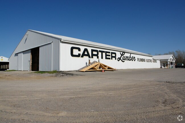
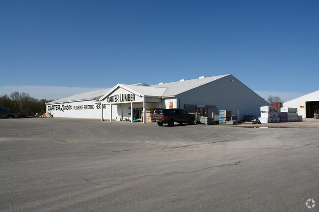
16700 S Us Highway 27, Lansing, MI 48906

NEARBY LISTINGS FOR SALE OR LEASE
Property Detail
16700 S Us Highway 27
050-033-400-030-60
Ft Tothe N Ln Of Auto Park Sub
Storebuilding
BEG 880 FT N OF SE COR OF W 1/2 OF SE 1/4 OF SEC 33 T5NR2W TH N 880 FT W 1841.9FT TO CENT TURNER RD SWLY ALG RD 682 FT E
X
Clinton
26065C0018D
Michigan
0
19.22 AC
2025
Central Lansing
010203
West Michigan
16,600 SF
Lansing-East Lansing, MI
DEMOGRAPHICS near 16700 S Us Highway 27
1 Mile
3 Mile
5 Mile
2024 Total Population
4,354
51,580
142,345
2029 Population
4,463
51,876
143,263
Pop Growth 2024-2029
+ 2.50%
+ 0.57%
+ 0.64%
Average Age
40
38
37
2024 Total Households
1,851
23,031
61,065
HH Growth 2024-2029
+ 2.59%
+ 0.47%
+ 0.62%
Median Household Inc
$49,526
$51,270
$51,013
Avg Household Size
2.30
2.10
2.20
2024 Avg HH Vehicles
2.00
2.00
2.00
Median Home Value
$102,670
$131,853
$157,854
Median Year Built
1957
1961
1965
Nearby Places
Map Layers
Map Styles
 Street
 Aerial
- Restaurants
- Banks
- Shops
- Fitness
- Groceries
PUBLIC TRANSPORTATION
AIRPORT
Capital Region International
DRIVE
WALK
Distance
Capital Region International
9 min
3.6 mi
Nearby Properties
Address
Land Use
TOTAL SIZE
Lot Size
Zoning
Address
Land Use
TOTAL SIZE
Lot Size
Zoning
42,875 SF
35 AC
PD
Address
Land Use
TOTAL SIZE
Lot Size
Zoning
7,579 SF
83.53 AC
PD
Address
Land Use
TOTAL SIZE
Lot Size
Zoning
42,875 SF
28.77 AC
Address
Land Use
TOTAL SIZE
Lot Size
Zoning
111,180 SF
3.63 AC
G-1 BUS
Address
Land Use
TOTAL SIZE
Lot Size
Zoning
177,300 SF
8.72 AC
Address
Land Use
TOTAL SIZE
Lot Size
Zoning
66.43 AC
Address
Land Use
TOTAL SIZE
Lot Size
Zoning
16,466 SF
14.82 AC
DEVELOPMEN
Address
Land Use
TOTAL SIZE
Lot Size
Zoning
2,137 SF
12.72 AC
H LT IN
Address
Land Use
TOTAL SIZE
Lot Size
Zoning
19,035 SF
12.32 AC
RM08
Address
Land Use
TOTAL SIZE
Lot Size
Zoning
20,438 SF
17.81 AC
DEVELOPMEN
Address
Land Use
TOTAL SIZE
Lot Size
Zoning
185,190 SF
0.41 AC
G-1 BUS
Address
Land Use
TOTAL SIZE
Lot Size
Zoning
300,760 SF
27.22 AC
RM08
Address
Land Use
TOTAL SIZE
Lot Size
Zoning
183,047 SF
24.36 AC
B4
Address
Land Use
TOTAL SIZE
Lot Size
Zoning
142,152 SF
47.56 AC
B4
Address
Land Use
TOTAL SIZE
Lot Size
Zoning
332,832 SF
2.48 AC
G-1 BUS
Address
Land Use
TOTAL SIZE
Lot Size
Zoning
51,248 SF
4.85 AC
I HVY
Address
Land Use
TOTAL SIZE
Lot Size
Zoning
169,704 SF
0.67 AC
G-1 BUS
Address
Land Use
TOTAL SIZE
Lot Size
Zoning
118,415 SF
4.74 AC
RM22
Address
Land Use
TOTAL SIZE
Lot Size
Zoning
63.94 AC
Address
Land Use
TOTAL SIZE
Lot Size
Zoning
165,684 SF
1.20 AC
G-1 BUS
Address
Land Use
TOTAL SIZE
Lot Size
Zoning
19,035 SF
11.98 AC
RM08
Address
Land Use
TOTAL SIZE
Lot Size
Zoning
159,455 SF
0.42 AC
Address
Land Use
TOTAL SIZE
Lot Size
Zoning
157,548 SF
0.72 AC
Address
Land Use
TOTAL SIZE
Lot Size
Zoning
61,194 SF
0.55 AC
F COMME
Address
Land Use
TOTAL SIZE
Lot Size
Zoning
67,365 SF
4.19 AC
H LT IN
Address
Land Use
TOTAL SIZE
Lot Size
Zoning
Address
Land Use
TOTAL SIZE
Lot Size
Zoning
29,292 SF
8.21 AC
DEVELOPMEN
Address
Land Use
TOTAL SIZE
Lot Size
Zoning
76,606 SF
1.75 AC
Address
Land Use
TOTAL SIZE
Lot Size
Zoning
140,722 SF
1.40 AC
Address
Land Use
TOTAL SIZE
Lot Size
Zoning
69,768 SF
8.22 AC
D ADMIN
The World's #1 Commercial Real Estate Marketplace
Connect with us
© 2026 CoStar Group
The information above has been obtained from sources believed reliable. While we do not doubt its accuracy we have not verified it and make no guarantee, warranty or representation about it. It is your responsibility to independently confirm its accuracy and completeness. Any projections, opinions, assumptions, or estimates used are for example only and do not represent the current or future performance of the property. The value of this transaction to you depends on tax and other factors which should be evaluated by your tax, financial, and legal advisors. You and your advisors should conduct a careful, independent investigation of the property to determine to your satisfaction the suitability of the property for your needs.