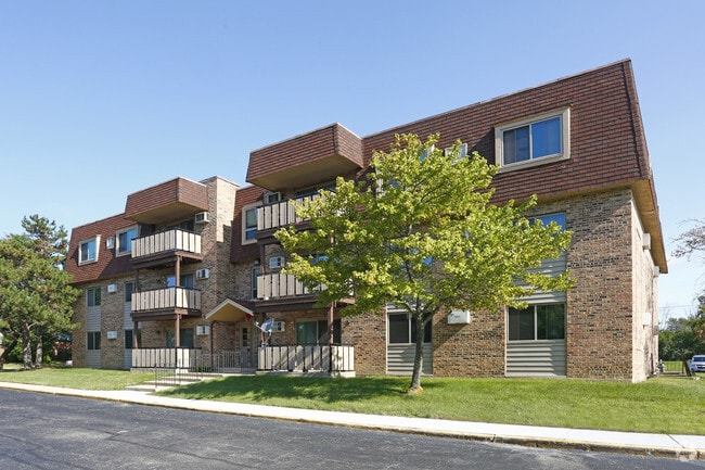
Property Record
16703 Lakewood Dr, Tinley Park, IL 60477
NEARBY LISTINGS FOR SALE OR LEASE
-
-
View all Tinley Park listings for sale on LoopNet.com
Property Detail
16703 Lakewood Dr
Chicago-Naperville-Elgin, IL-IN-WI
Edgewater Walk Phase1
28-29-200-003-0000
(EDGEWATER) (WALK) (PHASE1) SUB OF PT OF NE SEC 29-36-13
Apartment
Cook
AE
Illinois
17031C0709J
1
2023
7.17 AC
2025
Southwest Cook County
825302
Chicago
210,420 SF
DEMOGRAPHICS near 16703 Lakewood Dr
1 Mile
3 Mile
5 Mile
2024 Total Population
5,912
78,586
216,395
2029 Population
5,735
76,252
211,418
Pop Growth 2024-2029
(2.99%)
(2.97%)
(2.30%)
Average Age
41
42
42
2024 Total Households
2,323
30,833
81,164
HH Growth 2024-2029
(3.36%)
(3.27%)
(2.56%)
Median Household Inc
$90,397
$76,743
$76,763
Avg Household Size
2.50
2.50
2.60
2024 Avg HH Vehicles
2.00
2.00
2.00
Median Home Value
$245,797
$227,801
$230,587
Median Year Built
1969
1977
1978
Nearby Places
Map Layers
Map Styles
 Street
 Aerial
- Restaurants
- Banks
- Shops
- Fitness
- Groceries
PUBLIC TRANSPORTATION
COMMUTER RAIL
Tinley Park Station (Rock Island District Line - Northeast Illinois Regional Commuter Railroad (Metra))
DRIVE
WALK
Distance
Tinley Park Station (Rock Island District Line - Northeast Illinois Regional Commuter Railroad (Metra))
5 min
2.1 mi
Oak Forest Station (Rock Island District Line - Northeast Illinois Regional Commuter Railroad (Metra))
DRIVE
WALK
Distance
Oak Forest Station (Rock Island District Line - Northeast Illinois Regional Commuter Railroad (Metra))
5 min
2.6 mi
AIRPORT
Chicago Midway International
DRIVE
WALK
Distance
Chicago Midway International
27 min
16.2 mi
Chicago O'Hare International
DRIVE
WALK
Distance
Chicago O'Hare International
53 min
38.2 mi
Freight Ports
Port Milwaukee
DRIVE
WALK
Distance
Port Milwaukee
134 min
109.9 mi
Nearby Properties
Address
Land Use
TOTAL SIZE
Lot Size
Zoning
Address
Land Use
TOTAL SIZE
Lot Size
Zoning
Address
Land Use
TOTAL SIZE
Lot Size
Zoning
266,729 SF
20.64 AC
Address
Land Use
TOTAL SIZE
Lot Size
Zoning
134,148 SF
5 AC
Address
Land Use
TOTAL SIZE
Lot Size
Zoning
1,033,450 SF
Address
Land Use
TOTAL SIZE
Lot Size
Zoning
Address
Land Use
TOTAL SIZE
Lot Size
Zoning
911,379 SF
51.23 AC
Address
Land Use
TOTAL SIZE
Lot Size
Zoning
203,995 SF
20.27 AC
Address
Land Use
TOTAL SIZE
Lot Size
Zoning
132,193 SF
16.49 AC
Address
Land Use
TOTAL SIZE
Lot Size
Zoning
280,313 SF
12.75 AC
Address
Land Use
TOTAL SIZE
Lot Size
Zoning
114,484 SF
14.88 AC
Address
Land Use
TOTAL SIZE
Lot Size
Zoning
273,000 SF
20.69 AC
Address
Land Use
TOTAL SIZE
Lot Size
Zoning
208,523 SF
7.05 AC
Address
Land Use
TOTAL SIZE
Lot Size
Zoning
17.50 AC
Address
Land Use
TOTAL SIZE
Lot Size
Zoning
92,166 SF
23.83 AC
Address
Land Use
TOTAL SIZE
Lot Size
Zoning
124,846 SF
Address
Land Use
TOTAL SIZE
Lot Size
Zoning
110,590 SF
10.30 AC
Address
Land Use
TOTAL SIZE
Lot Size
Zoning
196,230 SF
25.52 AC
Address
Land Use
TOTAL SIZE
Lot Size
Zoning
Address
Land Use
TOTAL SIZE
Lot Size
Zoning
72,935 SF
2.90 AC
Address
Land Use
TOTAL SIZE
Lot Size
Zoning
59,948 SF
5.02 AC
Address
Land Use
TOTAL SIZE
Lot Size
Zoning
53,768 SF
3.91 AC
Address
Land Use
TOTAL SIZE
Lot Size
Zoning
297,330 SF
17.46 AC
Address
Land Use
TOTAL SIZE
Lot Size
Zoning
61,000 SF
4.34 AC
Address
Land Use
TOTAL SIZE
Lot Size
Zoning
3.87 AC
Address
Land Use
TOTAL SIZE
Lot Size
Zoning
125,337 SF
11.57 AC
Address
Land Use
TOTAL SIZE
Lot Size
Zoning
9.28 AC
Address
Land Use
TOTAL SIZE
Lot Size
Zoning
1.38 AC
Address
Land Use
TOTAL SIZE
Lot Size
Zoning
66,004 SF
7.47 AC
Address
Land Use
TOTAL SIZE
Lot Size
Zoning
64,944 SF
5.13 AC
Address
Land Use
TOTAL SIZE
Lot Size
Zoning
52,400 SF
2.49 AC
The World's #1 Commercial Real Estate Marketplace
Connect with us
© 2026 CoStar Group
The information above has been obtained from sources believed reliable. While we do not doubt its accuracy we have not verified it and make no guarantee, warranty or representation about it. It is your responsibility to independently confirm its accuracy and completeness. Any projections, opinions, assumptions, or estimates used are for example only and do not represent the current or future performance of the property. The value of this transaction to you depends on tax and other factors which should be evaluated by your tax, financial, and legal advisors. You and your advisors should conduct a careful, independent investigation of the property to determine to your satisfaction the suitability of the property for your needs.