Property Record
16705 State Road 50, Clermont, FL 34711


NEARBY LISTINGS FOR SALE OR LEASE
Property Detail
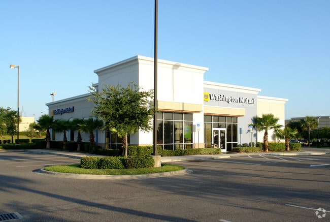
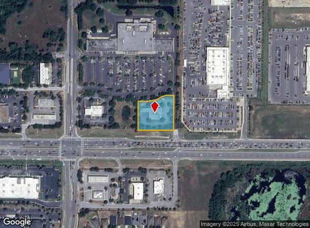
16705 State Road 50
09-22-26-1105-013-00001
Clermont Lake Highlands
Financialbuilding
CLERMONT LAKE HIGHLANDS 26-22-26 FROM N 1/4 COR RUN S 0-40-30 W 244.02 FT S 89-34-59 E 733.01 FT S 0-40-30 W 879.12 FT TO N R/W LINE OF SR 50 N 88-54-49 W 45 FT ALONG SAID N R/W LINE FOR POB CONT N 88-54-49 W 242.24 FT N 0-40-30 E 196.51 FT S 89-34-5
X
Lake
12095C0200H
Florida
2024
1.19 AC
2026
Lake County
031321
Orlando
4,988 SF
Orlando-Kissimmee-Sanford, FL
DEMOGRAPHICS near 16705 State Road 50
1 Mile
3 Mile
5 Mile
2024 Total Population
5,843
36,267
103,293
2029 Population
7,001
42,202
118,333
Pop Growth 2024-2029
+ 19.82%
+ 16.36%
+ 14.56%
Average Age
39
42
41
2024 Total Households
2,164
13,531
37,564
HH Growth 2024-2029
+ 19.78%
+ 16.36%
+ 14.53%
Median Household Inc
$90,999
$89,257
$87,226
Avg Household Size
2.70
2.60
2.70
2024 Avg HH Vehicles
2.00
2.00
2.00
Median Home Value
$335,957
$340,926
$345,883
Median Year Built
2008
2007
2005
Nearby Places
Map Layers
Map Styles
 Street
 Aerial
- Restaurants
- Banks
- Shops
- Fitness
- Groceries
PUBLIC TRANSPORTATION
AIRPORT
Orlando International
DRIVE
WALK
Distance
Orlando International
39 min
29.1 mi
Orlando Sanford International
DRIVE
WALK
Distance
Orlando Sanford International
59 min
46.5 mi
Freight Ports
Port of Tampa Bay
DRIVE
WALK
Distance
Port of Tampa Bay
103 min
81.9 mi
Nearby Properties
Address
Land Use
TOTAL SIZE
Lot Size
Zoning
Address
Land Use
TOTAL SIZE
Lot Size
Zoning
505,404 SF
16.10 AC
PUD
Address
Land Use
TOTAL SIZE
Lot Size
Zoning
425,675 SF
25.23 AC
Address
Land Use
TOTAL SIZE
Lot Size
Zoning
387,535 SF
22.94 AC
PUD
Address
Land Use
TOTAL SIZE
Lot Size
Zoning
285,581 SF
19.34 AC
CFD
Address
Land Use
TOTAL SIZE
Lot Size
Zoning
306,892 SF
21.96 AC
A
Address
Land Use
TOTAL SIZE
Lot Size
Zoning
2,000 SF
35.96 AC
PUD
Address
Land Use
TOTAL SIZE
Lot Size
Zoning
269,594 SF
25.23 AC
PUD
Address
Land Use
TOTAL SIZE
Lot Size
Zoning
212,649 SF
4.20 AC
Address
Land Use
TOTAL SIZE
Lot Size
Zoning
2,000 SF
26.79 AC
PUD
Address
Land Use
TOTAL SIZE
Lot Size
Zoning
118.31 AC
P-D
Address
Land Use
TOTAL SIZE
Lot Size
Zoning
273,592 SF
91.55 AC
R6
Address
Land Use
TOTAL SIZE
Lot Size
Zoning
133,767 SF
19.42 AC
I-1
Address
Land Use
TOTAL SIZE
Lot Size
Zoning
53,054 SF
11.65 AC
Address
Land Use
TOTAL SIZE
Lot Size
Zoning
53,982 SF
24.90 AC
Address
Land Use
TOTAL SIZE
Lot Size
Zoning
78,509 SF
18.68 AC
PUD
Address
Land Use
TOTAL SIZE
Lot Size
Zoning
52,986 SF
18.27 AC
Address
Land Use
TOTAL SIZE
Lot Size
Zoning
2,000 SF
30.62 AC
CFD
Address
Land Use
TOTAL SIZE
Lot Size
Zoning
57,124 SF
7.58 AC
Address
Land Use
TOTAL SIZE
Lot Size
Zoning
106,799 SF
9.06 AC
MP
Address
Land Use
TOTAL SIZE
Lot Size
Zoning
126,067 SF
9.34 AC
Address
Land Use
TOTAL SIZE
Lot Size
Zoning
62,897 SF
9.81 AC
MP
Address
Land Use
TOTAL SIZE
Lot Size
Zoning
62,794 SF
2.31 AC
Address
Land Use
TOTAL SIZE
Lot Size
Zoning
44,019 SF
9.39 AC
PUD
Address
Land Use
TOTAL SIZE
Lot Size
Zoning
153,522 SF
29.72 AC
PUD
Address
Land Use
TOTAL SIZE
Lot Size
Zoning
156,135 SF
19.72 AC
Address
Land Use
TOTAL SIZE
Lot Size
Zoning
148,143 SF
0.45 AC
A
Address
Land Use
TOTAL SIZE
Lot Size
Zoning
49,437 SF
9.35 AC
CP
Address
Land Use
TOTAL SIZE
Lot Size
Zoning
178,735 SF
20.68 AC
PUD
Address
Land Use
TOTAL SIZE
Lot Size
Zoning
87,951 SF
5.88 AC
Address
Land Use
TOTAL SIZE
Lot Size
Zoning
135,311 SF
18.18 AC
MP
The World's #1 Commercial Real Estate Marketplace
Connect with us
© 2025 CoStar Group
The information above has been obtained from sources believed reliable. While we do not doubt its accuracy we have not verified it and make no guarantee, warranty or representation about it. It is your responsibility to independently confirm its accuracy and completeness. Any projections, opinions, assumptions, or estimates used are for example only and do not represent the current or future performance of the property. The value of this transaction to you depends on tax and other factors which should be evaluated by your tax, financial, and legal advisors. You and your advisors should conduct a careful, independent investigation of the property to determine to your satisfaction the suitability of the property for your needs.