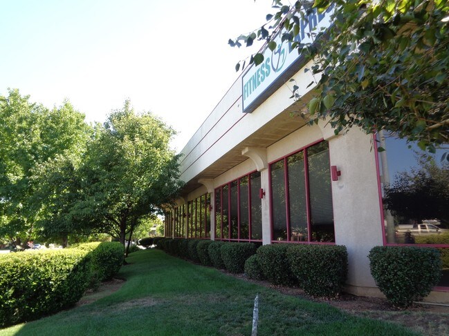
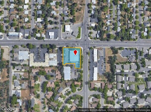
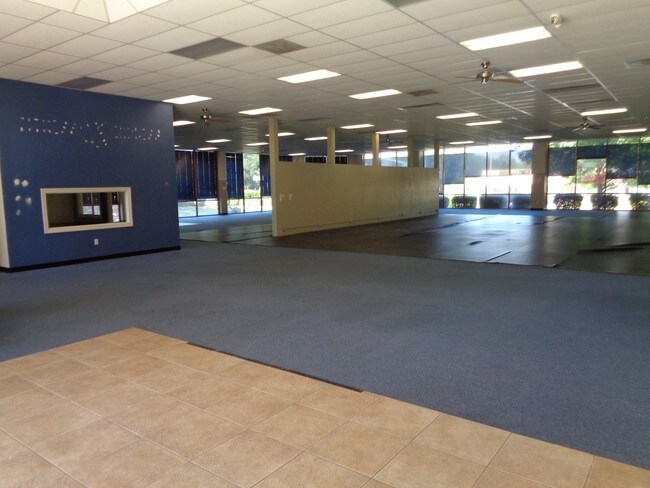
Property Record
1671 Hartnell Ave, Redding, CA 96002

NEARBY LISTINGS FOR SALE OR LEASE
Property Detail
1671 Hartnell Ave
Storebuilding
Shasta
X
California
06089C1554G
1 AC
2024
Other Market Areas
2025
Redding, CA
011209
068-080-057-000
11,769 SF
DEMOGRAPHICS near 1671 Hartnell Ave
1 Mile
3 Mile
5 Mile
2024 Total Population
13,959
55,002
98,687
2029 Population
13,916
54,936
98,738
Pop Growth 2024-2029
(0.31%)
(0.12%)
+ 0.05%
Average Age
38
40
41
2024 Total Households
5,219
21,761
39,668
HH Growth 2024-2029
(0.31%)
(0.09%)
+ 0.10%
Median Household Inc
$59,176
$64,891
$62,387
Avg Household Size
2.60
2.40
2.40
2024 Avg HH Vehicles
2.00
2.00
2.00
Median Home Value
$272,520
$335,785
$351,623
Median Year Built
1977
1981
1982
Nearby Places
Map Layers
Map Styles
 Street
 Aerial
- Restaurants
- Banks
- Shops
- Fitness
- Groceries
PUBLIC TRANSPORTATION
COMMUTER RAIL
Redding Amtrak (Coast Starlight - Amtrak)
DRIVE
WALK
Distance
Redding Amtrak (Coast Starlight - Amtrak)
7 min
4.5 mi
AIRPORT
Redding Regional
DRIVE
WALK
Distance
Redding Regional
9 min
5.9 mi
Freight Ports
Port of Richmond
DRIVE
WALK
Distance
Port of Richmond
230 min
202.9 mi
SALE & LEASE HISTORY
LISTING DATE
SALE/LEASE

Sep 23, 2016
For Sale
Nov 17, 2016
For Lease
Nov 01, 2016
For Sale
Nearby Properties
Address
Land Use
TOTAL SIZE
Lot Size
Zoning
Address
Land Use
TOTAL SIZE
Lot Size
Zoning
15.20 AC
Address
Land Use
TOTAL SIZE
Lot Size
Zoning
2.60 AC
Address
Land Use
TOTAL SIZE
Lot Size
Zoning
151,773 SF
17.64 AC
Address
Land Use
TOTAL SIZE
Lot Size
Zoning
1,016 SF
14.35 AC
Address
Land Use
TOTAL SIZE
Lot Size
Zoning
140.36 AC
Address
Land Use
TOTAL SIZE
Lot Size
Zoning
72,875 SF
3.93 AC
Address
Land Use
TOTAL SIZE
Lot Size
Zoning
31,365 SF
1.33 AC
Address
Land Use
TOTAL SIZE
Lot Size
Zoning
8.22 AC
Address
Land Use
TOTAL SIZE
Lot Size
Zoning
223,579 SF
19.65 AC
Address
Land Use
TOTAL SIZE
Lot Size
Zoning
Address
Land Use
TOTAL SIZE
Lot Size
Zoning
89,098 SF
7.24 AC
Address
Land Use
TOTAL SIZE
Lot Size
Zoning
21,089 SF
7 AC
Address
Land Use
TOTAL SIZE
Lot Size
Zoning
47,062 SF
4.80 AC
Address
Land Use
TOTAL SIZE
Lot Size
Zoning
73,000 SF
4.40 AC
Address
Land Use
TOTAL SIZE
Lot Size
Zoning
143,164 SF
13.90 AC
Address
Land Use
TOTAL SIZE
Lot Size
Zoning
19,572 SF
5.94 AC
Address
Land Use
TOTAL SIZE
Lot Size
Zoning
81,800 SF
14.81 AC
Address
Land Use
TOTAL SIZE
Lot Size
Zoning
5.44 AC
Address
Land Use
TOTAL SIZE
Lot Size
Zoning
50,251 SF
4.06 AC
Address
Land Use
TOTAL SIZE
Lot Size
Zoning
61,754 SF
1.73 AC
Address
Land Use
TOTAL SIZE
Lot Size
Zoning
92,699 SF
5.91 AC
Address
Land Use
TOTAL SIZE
Lot Size
Zoning
10.27 AC
Address
Land Use
TOTAL SIZE
Lot Size
Zoning
11.90 AC
Address
Land Use
TOTAL SIZE
Lot Size
Zoning
95,645 SF
9.55 AC
Address
Land Use
TOTAL SIZE
Lot Size
Zoning
2.42 AC
Address
Land Use
TOTAL SIZE
Lot Size
Zoning
101,683 SF
8.48 AC
Address
Land Use
TOTAL SIZE
Lot Size
Zoning
83,276 SF
3.02 AC
Address
Land Use
TOTAL SIZE
Lot Size
Zoning
16,320 SF
3.76 AC
Address
Land Use
TOTAL SIZE
Lot Size
Zoning
55,351 SF
5.65 AC
Address
Land Use
TOTAL SIZE
Lot Size
Zoning
63,837 SF
0.69 AC
The World's #1 Commercial Real Estate Marketplace
Connect with us
© 2026 CoStar Group
The information above has been obtained from sources believed reliable. While we do not doubt its accuracy we have not verified it and make no guarantee, warranty or representation about it. It is your responsibility to independently confirm its accuracy and completeness. Any projections, opinions, assumptions, or estimates used are for example only and do not represent the current or future performance of the property. The value of this transaction to you depends on tax and other factors which should be evaluated by your tax, financial, and legal advisors. You and your advisors should conduct a careful, independent investigation of the property to determine to your satisfaction the suitability of the property for your needs.