Property Record
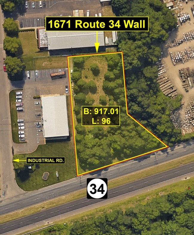
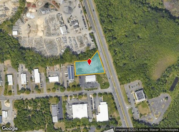
1671 Highway 34, Wall Township, NJ 07727
NEARBY LISTINGS FOR SALE OR LEASE
Property Detail
1671 Highway 34
New York-Jersey City-White Plains, NY-NJ
Industrial Park Sec 01
52-00917-01-00096
Monmouth
Vacantlandnec
New Jersey
X
96
34025C0328F
44 SF
2024
Western Monmouth
2025
Northern New Jersey
808600
DEMOGRAPHICS near 1671 Highway 34
1 Mile
3 Mile
5 Mile
2024 Total Population
741
16,220
77,485
2029 Population
712
16,145
77,438
Pop Growth 2024-2029
(3.91%)
(0.46%)
(0.06%)
Average Age
38
43
45
2024 Total Households
249
6,010
31,265
HH Growth 2024-2029
(4.02%)
(0.72%)
(0.31%)
Median Household Inc
$117,091
$112,767
$103,929
Avg Household Size
3.00
2.60
2.40
2024 Avg HH Vehicles
2.00
2.00
2.00
Median Home Value
$580,952
$488,303
$463,485
Median Year Built
1976
1981
1980
Nearby Places
- Restaurants
- Banks
- Shops
- Fitness
- Groceries
PUBLIC TRANSPORTATION
COMMUTER RAIL
Spring Lake (North Jersey Coast Line - NJ Transit Commuter Rail (NJ Transit))
DRIVE
WALK
Distance
Spring Lake (North Jersey Coast Line - NJ Transit Commuter Rail (NJ Transit))
10 min
6.5 mi
Belmar (North Jersey Coast Line - NJ Transit Commuter Rail (NJ Transit))
DRIVE
WALK
Distance
Belmar (North Jersey Coast Line - NJ Transit Commuter Rail (NJ Transit))
8 min
6.5 mi
Freight Ports
New York Container Terminal
DRIVE
WALK
Distance
New York Container Terminal
56 min
43.2 mi
SALE & LEASE HISTORY
LISTING DATE
SALE/LEASE

Sep 24, 2016
For Sale
Nov 14, 2016
For Sale
Jan 28, 2019
For Sale
Nearby Properties
Address
Land Use
TOTAL SIZE
Lot Size
Zoning
Address
Land Use
TOTAL SIZE
Lot Size
Zoning
434,405 SF
52.92 AC
RT66
Address
Land Use
TOTAL SIZE
Lot Size
Zoning
37.47 AC
AH
Address
Land Use
TOTAL SIZE
Lot Size
Zoning
152,121 SF
22.16 AC
OR10
Address
Land Use
TOTAL SIZE
Lot Size
Zoning
25.37 AC
C-1
Address
Land Use
TOTAL SIZE
Lot Size
Zoning
192,708 SF
33.36 AC
OR10
Address
Land Use
TOTAL SIZE
Lot Size
Zoning
181,064 SF
14.62 AC
IL
Address
Land Use
TOTAL SIZE
Lot Size
Zoning
3,040 SF
194.08 AC
OSGS
Address
Land Use
TOTAL SIZE
Lot Size
Zoning
3,094 SF
277.60 AC
C
Address
Land Use
TOTAL SIZE
Lot Size
Zoning
183,932 SF
23.51 AC
IL
Address
Land Use
TOTAL SIZE
Lot Size
Zoning
13,200 SF
18.63 AC
PUDR
Address
Land Use
TOTAL SIZE
Lot Size
Zoning
25,536 SF
21.95 AC
OR10
Address
Land Use
TOTAL SIZE
Lot Size
Zoning
17,586 SF
386.01 AC
POS
Address
Land Use
TOTAL SIZE
Lot Size
Zoning
145,918 SF
20.31 AC
OR-5
Address
Land Use
TOTAL SIZE
Lot Size
Zoning
8,100 SF
50.70 AC
IOP
Address
Land Use
TOTAL SIZE
Lot Size
Zoning
28,819 SF
13.59 AC
ES
Address
Land Use
TOTAL SIZE
Lot Size
Zoning
912 SF
201.36 AC
RRC
Address
Land Use
TOTAL SIZE
Lot Size
Zoning
117,915 SF
17.32 AC
C-1
Address
Land Use
TOTAL SIZE
Lot Size
Zoning
3,400 SF
262.97 AC
AI
Address
Land Use
TOTAL SIZE
Lot Size
Zoning
332,213 SF
26.55 AC
OR10
Address
Land Use
TOTAL SIZE
Lot Size
Zoning
8,749 SF
5.73 AC
OPML
Address
Land Use
TOTAL SIZE
Lot Size
Zoning
2,976 SF
336.41 AC
POS
Address
Land Use
TOTAL SIZE
Lot Size
Zoning
71,660 SF
4.45 AC
C-1
Address
Land Use
TOTAL SIZE
Lot Size
Zoning
7,350 SF
161.08 AC
MFG
Address
Land Use
TOTAL SIZE
Lot Size
Zoning
14,874 SF
12.49 AC
OP10
Address
Land Use
TOTAL SIZE
Lot Size
Zoning
2,656 SF
95.46 AC
POS
Address
Land Use
TOTAL SIZE
Lot Size
Zoning
142,676 SF
10.47 AC
OR-2
Address
Land Use
TOTAL SIZE
Lot Size
Zoning
257.92 AC
POS
Address
Land Use
TOTAL SIZE
Lot Size
Zoning
22,700 SF
7.53 AC
POS
Address
Land Use
TOTAL SIZE
Lot Size
Zoning
3,474 SF
4.12 AC
OR10
Address
Land Use
TOTAL SIZE
Lot Size
Zoning
76,289 SF
3.44 AC
R20
The World's #1 Commercial Real Estate Marketplace
Connect with us
© 2025 CoStar Group
The information above has been obtained from sources believed reliable. While we do not doubt its accuracy we have not verified it and make no guarantee, warranty or representation about it. It is your responsibility to independently confirm its accuracy and completeness. Any projections, opinions, assumptions, or estimates used are for example only and do not represent the current or future performance of the property. The value of this transaction to you depends on tax and other factors which should be evaluated by your tax, financial, and legal advisors. You and your advisors should conduct a careful, independent investigation of the property to determine to your satisfaction the suitability of the property for your needs.