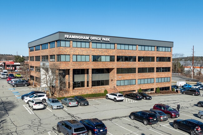
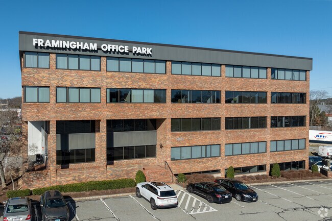
Property Record
1671 Worcester Rd, Framingham, MA 01701


Current Lease Availabilities
Property Detail
1671 Worcester Rd
FRAM-000096-000003-008595
Middlesex
Officebuilding
Massachusetts
M
8595
B and X Area of moderate flood hazard, usually the area between the limits of the 100-year and 500-year floods.
4.08 AC
2025
Framingham/Natick
2025
Boston
384003
Boston-Cambridge-Newton, MA-NH
48,304 SF
NEARBY LISTINGS FOR SALE OR LEASE
DEMOGRAPHICS near 1671 Worcester Rd
1 mile
3 mile
5 mile
2025 Total Population
3,740
38,809
143,100
2030 Population
3,936
40,547
149,119
Pop Growth 2025-2030
+ 5.24%
+ 4.48%
+ 4.21%
Average Age
40
41
41
2025 Total Households
1,683
14,551
55,045
HH Growth 2025-2030
+ 5.64%
+ 4.74%
+ 4.35%
Median Household Inc
$105,332
$136,052
$108,110
Avg Household Size
2.10
2.50
2.50
2025 Avg HH Vehicles
2.00
2.00
2.00
Median Home Value
$761,764
$747,314
$683,940
Median Year Built
1976
1973
1971
Nearby Places
Map Layers
Map Styles
 Street
 Aerial
Layers
 Traffic
 Biking
Places
Listings with unknown addresses are not visible on the map
- Restaurants
- Banks
- Shops
- Fitness
- Groceries
PUBLIC TRANSPORTATION
COMMUTER RAIL
Southborough (Framingham/Worcester Line - Massachusetts Bay Transportation Authority Commuter Rail (Purple Line))
Drive
Walk
Distance
Southborough (Framingham/Worcester Line - Massachusetts Bay Transportation Authority Commuter Rail (Purple Line))
9 min
3.6 mi
Ashland (Framingham/Worcester Line - Massachusetts Bay Transportation Authority Commuter Rail (Purple Line))
Drive
Walk
Distance
Ashland (Framingham/Worcester Line - Massachusetts Bay Transportation Authority Commuter Rail (Purple Line))
9 min
4.5 mi
AIRPORT
Worcester Regional
Drive
Walk
Distance
Worcester Regional
38 min
21.8 mi
General Edward Lawrence Logan International
Drive
Walk
Distance
General Edward Lawrence Logan International
39 min
27.8 mi
Freight Ports
Port of Boston
Drive
Walk
Distance
Port of Boston
38 min
26.2 mi
Nearby Properties
Address
Land Use
TOTAL SIZE
Lot Size
Zoning
Address
Land Use
TOTAL SIZE
Lot Size
Zoning
556,849 SF
28.44 AC
R4
Address
Land Use
TOTAL SIZE
Lot Size
Zoning
906,841 SF
47.93 AC
M1
Address
Land Use
TOTAL SIZE
Lot Size
Zoning
664,397 SF
15.78 AC
TP
Address
Land Use
TOTAL SIZE
Lot Size
Zoning
340,840 SF
4.25 AC
B
Address
Land Use
TOTAL SIZE
Lot Size
Zoning
292,608 SF
5.19 AC
B
Address
Land Use
TOTAL SIZE
Lot Size
Zoning
493,918 SF
28.90 AC
R1
Address
Land Use
TOTAL SIZE
Lot Size
Zoning
293,180 SF
5.10 AC
B
Address
Land Use
TOTAL SIZE
Lot Size
Zoning
264,247 SF
6.09 AC
M1
Address
Land Use
TOTAL SIZE
Lot Size
Zoning
273,474 SF
7.46 AC
B
Address
Land Use
TOTAL SIZE
Lot Size
Zoning
444,182 SF
32.91 AC
TP
Address
Land Use
TOTAL SIZE
Lot Size
Zoning
8,160 SF
11 AC
RA
Address
Land Use
TOTAL SIZE
Lot Size
Zoning
207,522 SF
10.11 AC
B
Address
Land Use
TOTAL SIZE
Lot Size
Zoning
191,520 SF
7.99 AC
B
Address
Land Use
TOTAL SIZE
Lot Size
Zoning
191,520 SF
5.03 AC
B
Address
Land Use
TOTAL SIZE
Lot Size
Zoning
244,033 SF
25.75 AC
R1
Address
Land Use
TOTAL SIZE
Lot Size
Zoning
231,897 SF
7.90 AC
B
Address
Land Use
TOTAL SIZE
Lot Size
Zoning
174,988 SF
5.54 AC
TP
Address
Land Use
TOTAL SIZE
Lot Size
Zoning
15,204 SF
5.79 AC
BH
Address
Land Use
TOTAL SIZE
Lot Size
Zoning
112,000 SF
18.48 AC
R1
Address
Land Use
TOTAL SIZE
Lot Size
Zoning
150,636 SF
30.34 AC
GE
Address
Land Use
TOTAL SIZE
Lot Size
Zoning
35,211 SF
89 AC
RA
Address
Land Use
TOTAL SIZE
Lot Size
Zoning
1,976 SF
81.69 AC
RA
Address
Land Use
TOTAL SIZE
Lot Size
Zoning
289,642 SF
8.13 AC
M
Address
Land Use
TOTAL SIZE
Lot Size
Zoning
202,609 SF
1.70 AC
TP
Address
Land Use
TOTAL SIZE
Lot Size
Zoning
149,806 SF
11.20 AC
B
Address
Land Use
TOTAL SIZE
Lot Size
Zoning
67,760 SF
11.65 AC
RB
Address
Land Use
TOTAL SIZE
Lot Size
Zoning
121,889 SF
2.01 AC
M1
Address
Land Use
TOTAL SIZE
Lot Size
Zoning
101,140 SF
10 AC
TP
Address
Land Use
TOTAL SIZE
Lot Size
Zoning
6,420 SF
28 AC
IP
Address
Land Use
TOTAL SIZE
Lot Size
Zoning
115,879 SF
0.32 AC
R1
The World's #1 Commercial Real Estate Marketplace
Connect with us
© 2026 CoStar Group
The information above has been obtained from sources believed reliable. While we do not doubt its accuracy we have not verified it and make no guarantee, warranty or representation about it. It is your responsibility to independently confirm its accuracy and completeness. Any projections, opinions, assumptions, or estimates used are for example only and do not represent the current or future performance of the property. The value of this transaction to you depends on tax and other factors which should be evaluated by your tax, financial, and legal advisors. You and your advisors should conduct a careful, independent investigation of the property to determine to your satisfaction the suitability of the property for your needs.