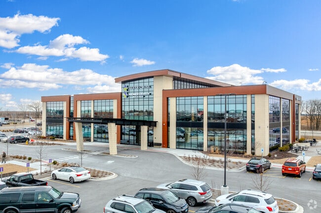
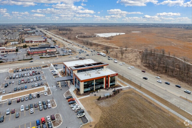
Property Record
16727 La Grange Rd, Tinley Park, IL 60487

NEARBY LISTINGS FOR SALE OR LEASE
Property Detail
16727 La Grange Rd
27-27-100-027-0000
Cook
Storebuilding
Illinois
2023
South Route 45
2024
Chicago
824126
Chicago-Naperville-Elgin, IL-IN
DEMOGRAPHICS near 16727 La Grange Rd
1 Mile
3 Mile
5 Mile
2024 Total Population
7,272
71,383
172,040
2029 Population
7,029
69,188
167,829
Pop Growth 2024-2029
(3.34%)
(3.07%)
(2.45%)
Average Age
43
44
43
2024 Total Households
2,551
26,907
64,733
HH Growth 2024-2029
(3.68%)
(3.39%)
(2.75%)
Median Household Inc
$107,855
$93,066
$96,420
Avg Household Size
2.80
2.60
2.60
2024 Avg HH Vehicles
2.00
2.00
2.00
Median Home Value
$276,032
$293,134
$297,999
Median Year Built
1989
1989
1986
Nearby Places
Map Layers
Map Styles
 Street
 Aerial
- Restaurants
- Banks
- Shops
- Fitness
- Groceries
PUBLIC TRANSPORTATION
COMMUTER RAIL
Orland Park - 153Rd Street Station (SouthWest Service - Northeast Illinois Regional Commuter Railroad (Metra))
DRIVE
WALK
Distance
Orland Park - 153Rd Street Station (SouthWest Service - Northeast Illinois Regional Commuter Railroad (Metra))
8 min
3.4 mi
Hickory Creek (Rock Island - Metra)
DRIVE
WALK
Distance
Hickory Creek (Rock Island - Metra)
9 min
4.3 mi
AIRPORT
Chicago Midway International
DRIVE
WALK
Distance
Chicago Midway International
29 min
19.8 mi
Chicago O'Hare International
DRIVE
WALK
Distance
Chicago O'Hare International
50 min
30.3 mi
Freight Ports
Port Milwaukee
DRIVE
WALK
Distance
Port Milwaukee
132 min
107.0 mi
Nearby Properties
Address
Land Use
TOTAL SIZE
Lot Size
Zoning
Address
Land Use
TOTAL SIZE
Lot Size
Zoning
68,954 SF
Address
Land Use
TOTAL SIZE
Lot Size
Zoning
673,462 SF
41.34 AC
Address
Land Use
TOTAL SIZE
Lot Size
Zoning
298,700 SF
Address
Land Use
TOTAL SIZE
Lot Size
Zoning
8.38 AC
Address
Land Use
TOTAL SIZE
Lot Size
Zoning
67,394 SF
6.72 AC
Address
Land Use
TOTAL SIZE
Lot Size
Zoning
188,930 SF
9.40 AC
Address
Land Use
TOTAL SIZE
Lot Size
Zoning
Address
Land Use
TOTAL SIZE
Lot Size
Zoning
216,735 SF
11.33 AC
Address
Land Use
TOTAL SIZE
Lot Size
Zoning
103,110 SF
9.12 AC
Address
Land Use
TOTAL SIZE
Lot Size
Zoning
111,100 SF
8.87 AC
Address
Land Use
TOTAL SIZE
Lot Size
Zoning
79,455 SF
5.36 AC
Address
Land Use
TOTAL SIZE
Lot Size
Zoning
304,608 SF
19.51 AC
Address
Land Use
TOTAL SIZE
Lot Size
Zoning
6.16 AC
Address
Land Use
TOTAL SIZE
Lot Size
Zoning
155,657 SF
15.68 AC
Address
Land Use
TOTAL SIZE
Lot Size
Zoning
238,068 SF
13.96 AC
Address
Land Use
TOTAL SIZE
Lot Size
Zoning
454,002 SF
10.50 AC
Address
Land Use
TOTAL SIZE
Lot Size
Zoning
200,815 SF
10 AC
Address
Land Use
TOTAL SIZE
Lot Size
Zoning
94,932 SF
8.02 AC
Address
Land Use
TOTAL SIZE
Lot Size
Zoning
202,591 SF
16.29 AC
Address
Land Use
TOTAL SIZE
Lot Size
Zoning
160,014 SF
13.04 AC
Address
Land Use
TOTAL SIZE
Lot Size
Zoning
216,900 SF
10.11 AC
Address
Land Use
TOTAL SIZE
Lot Size
Zoning
135,849 SF
12.77 AC
Address
Land Use
TOTAL SIZE
Lot Size
Zoning
Address
Land Use
TOTAL SIZE
Lot Size
Zoning
Address
Land Use
TOTAL SIZE
Lot Size
Zoning
67,783 SF
4.34 AC
Address
Land Use
TOTAL SIZE
Lot Size
Zoning
122,846 SF
17.42 AC
Address
Land Use
TOTAL SIZE
Lot Size
Zoning
23.67 AC
Address
Land Use
TOTAL SIZE
Lot Size
Zoning
253,215 SF
29.36 AC
Address
Land Use
TOTAL SIZE
Lot Size
Zoning
108,890 SF
10.01 AC
The World's #1 Commercial Real Estate Marketplace
Connect with us
© 2026 CoStar Group
The information above has been obtained from sources believed reliable. While we do not doubt its accuracy we have not verified it and make no guarantee, warranty or representation about it. It is your responsibility to independently confirm its accuracy and completeness. Any projections, opinions, assumptions, or estimates used are for example only and do not represent the current or future performance of the property. The value of this transaction to you depends on tax and other factors which should be evaluated by your tax, financial, and legal advisors. You and your advisors should conduct a careful, independent investigation of the property to determine to your satisfaction the suitability of the property for your needs.