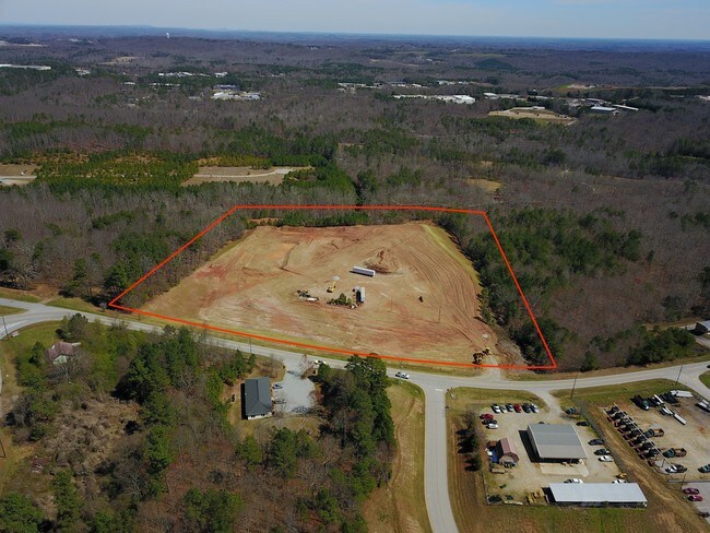
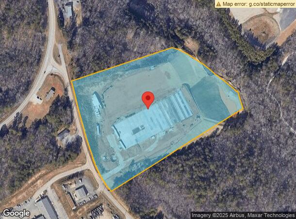
Property Record
1673 Barber Rd, Gainesville, GA 30507
NEARBY LISTINGS FOR SALE OR LEASE
Property Detail
1673 Barber Rd
Gainesville, GA
Jim H Brooks
15-00031-00-053
CALVARY CHURCH ROAD
Manufacturinglight
Hall
X
Georgia
13013C0025D
0
2025
15 AC
2025
Gainesville/Hall County
001204
Atlanta
91,728 SF
DEMOGRAPHICS near 1673 Barber Rd
1 Mile
3 Mile
5 Mile
2024 Total Population
460
19,968
77,558
2029 Population
510
21,848
85,957
Pop Growth 2024-2029
+ 10.87%
+ 9.42%
+ 10.83%
Average Age
34
33
35
2024 Total Households
82
5,632
24,898
HH Growth 2024-2029
+ 12.20%
+ 9.22%
+ 10.83%
Median Household Inc
$68,499
$58,492
$56,462
Avg Household Size
3.70
3.30
3.00
2024 Avg HH Vehicles
3.00
2.00
2.00
Median Home Value
$205,357
$213,353
$229,783
Median Year Built
1994
1994
1993
Nearby Places
Map Layers
Map Styles
 Street
 Aerial
- Restaurants
- Banks
- Shops
- Fitness
- Groceries
PUBLIC TRANSPORTATION
COMMUTER RAIL
Gainesville Amtrak Station (Crescent - Amtrak)
DRIVE
WALK
Distance
Gainesville Amtrak Station (Crescent - Amtrak)
7 min
3.5 mi
Freight Ports
Georgia Ports - Savannah
DRIVE
WALK
Distance
Georgia Ports - Savannah
320 min
252.8 mi
SALE & LEASE HISTORY
LISTING DATE
SALE/LEASE

May 29, 2019
For Sale
Nearby Properties
Address
Land Use
TOTAL SIZE
Lot Size
Zoning
Address
Land Use
TOTAL SIZE
Lot Size
Zoning
578,645 SF
110.18 AC
PUD
Address
Land Use
TOTAL SIZE
Lot Size
Zoning
334,800 SF
56.96 AC
PUD
Address
Land Use
TOTAL SIZE
Lot Size
Zoning
760,440 SF
53.33 AC
L-I
Address
Land Use
TOTAL SIZE
Lot Size
Zoning
346,875 SF
82.09 AC
H-I
Address
Land Use
TOTAL SIZE
Lot Size
Zoning
54,751 SF
33.38 AC
AR-1
Address
Land Use
TOTAL SIZE
Lot Size
Zoning
277,684 SF
23.06 AC
L-I
Address
Land Use
TOTAL SIZE
Lot Size
Zoning
469,180 SF
25.56 AC
H-I
Address
Land Use
TOTAL SIZE
Lot Size
Zoning
258,372 SF
24.38 AC
L-I
Address
Land Use
TOTAL SIZE
Lot Size
Zoning
88,042 SF
280.24 AC
PID
Address
Land Use
TOTAL SIZE
Lot Size
Zoning
308,672 SF
41.22 AC
L-I
Address
Land Use
TOTAL SIZE
Lot Size
Zoning
1,191 SF
262.63 AC
H-I
Address
Land Use
TOTAL SIZE
Lot Size
Zoning
258,800 SF
52.20 AC
H-I
Address
Land Use
TOTAL SIZE
Lot Size
Zoning
304,088 SF
17.45 AC
H-I
Address
Land Use
TOTAL SIZE
Lot Size
Zoning
192,177 SF
12.43 AC
PRD
Address
Land Use
TOTAL SIZE
Lot Size
Zoning
102,996 SF
10.94 AC
L-I
Address
Land Use
TOTAL SIZE
Lot Size
Zoning
301,380 SF
16.76 AC
I-1
Address
Land Use
TOTAL SIZE
Lot Size
Zoning
59,256 SF
7.27 AC
PRD
Address
Land Use
TOTAL SIZE
Lot Size
Zoning
199,610 SF
14.66 AC
L-I
Address
Land Use
TOTAL SIZE
Lot Size
Zoning
16,560 SF
9.62 AC
PRD
Address
Land Use
TOTAL SIZE
Lot Size
Zoning
45,986 SF
28.83 AC
L-I
Address
Land Use
TOTAL SIZE
Lot Size
Zoning
286,880 SF
18.38 AC
H-I
Address
Land Use
TOTAL SIZE
Lot Size
Zoning
18,126 SF
14.65 AC
AR-1
Address
Land Use
TOTAL SIZE
Lot Size
Zoning
206,125 SF
32.78 AC
L-I
Address
Land Use
TOTAL SIZE
Lot Size
Zoning
145,064 SF
7.47 AC
I-1
Address
Land Use
TOTAL SIZE
Lot Size
Zoning
13,250 SF
17.37 AC
EX
Address
Land Use
TOTAL SIZE
Lot Size
Zoning
6,720 SF
1,027.20 AC
EX
Address
Land Use
TOTAL SIZE
Lot Size
Zoning
33,351 SF
16.80 AC
R-1
Address
Land Use
TOTAL SIZE
Lot Size
Zoning
162,813 SF
11.24 AC
H-I
Address
Land Use
TOTAL SIZE
Lot Size
Zoning
50,000 SF
12.53 AC
L-I
The World's #1 Commercial Real Estate Marketplace
Connect with us
© 2025 CoStar Group
The information above has been obtained from sources believed reliable. While we do not doubt its accuracy we have not verified it and make no guarantee, warranty or representation about it. It is your responsibility to independently confirm its accuracy and completeness. Any projections, opinions, assumptions, or estimates used are for example only and do not represent the current or future performance of the property. The value of this transaction to you depends on tax and other factors which should be evaluated by your tax, financial, and legal advisors. You and your advisors should conduct a careful, independent investigation of the property to determine to your satisfaction the suitability of the property for your needs.