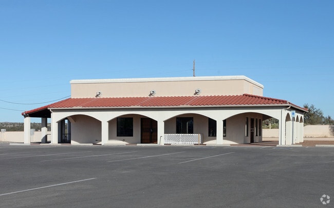
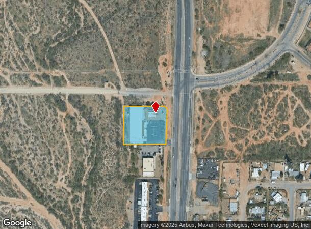
Property Record
16733 N Oracle Rd, Tucson, AZ 85739


NEARBY LISTINGS FOR SALE OR LEASE
-
-
View all Tucson listings for sale on LoopNet.com
Property Detail
16733 N Oracle Rd
Tucson, AZ
Bonanza Heights
222-17-001A
BONANZA HEIGHTS PTN N250.77 LOT 1
Publicstorage
Pima
X
Arizona
04019C0495L
1
2025
1.54 AC
2026
North/Oro Valley
004727
Tucson
19,164 SF
DEMOGRAPHICS near 16733 N Oracle Rd
1 mile
3 mile
5 mile
2024 Total Population
3,330
14,313
27,955
2029 Population
3,866
16,320
31,834
Pop Growth 2024-2029
+ 16.10%
+ 14.02%
+ 13.88%
Average Age
48
55
60
2024 Total Households
1,386
6,451
13,352
HH Growth 2024-2029
+ 16.31%
+ 14.79%
+ 14.43%
Median Household Inc
$70,499
$75,125
$85,074
Avg Household Size
2.40
2.20
2.00
2024 Avg HH Vehicles
2.00
2.00
2.00
Median Home Value
$339,359
$362,545
$394,617
Median Year Built
2003
2000
1997
Nearby Places
Map Layers
Map Styles
 Street
 Aerial
Transit
 Traffic
 Biking
Places
Listings with unknown addresses are not visible on the map
- Restaurants
- Banks
- Shops
- Fitness
- Groceries
PUBLIC TRANSPORTATION
AIRPORT
Tucson International
Drive
Walk
Distance
Tucson International
51 min
29.9 mi
Nearby Properties
Address
Land Use
TOTAL SIZE
Lot Size
Zoning
Address
Land Use
TOTAL SIZE
Lot Size
Zoning
130,249 SF
175.94 AC
SP
Address
Land Use
TOTAL SIZE
Lot Size
Zoning
30,340 SF
5.17 AC
CB1
Address
Land Use
TOTAL SIZE
Lot Size
Zoning
171,794 SF
45.61 AC
GR1
Address
Land Use
TOTAL SIZE
Lot Size
Zoning
6,000 SF
11.87 AC
Address
Land Use
TOTAL SIZE
Lot Size
Zoning
66,253 SF
7.07 AC
CB1
Address
Land Use
TOTAL SIZE
Lot Size
Zoning
38,076 SF
8.86 AC
GR1
Address
Land Use
TOTAL SIZE
Lot Size
Zoning
21,734 SF
4.68 AC
Address
Land Use
TOTAL SIZE
Lot Size
Zoning
Address
Land Use
TOTAL SIZE
Lot Size
Zoning
576 SF
3.99 AC
GR1
Address
Land Use
TOTAL SIZE
Lot Size
Zoning
1,890 SF
0.23 AC
Address
Land Use
TOTAL SIZE
Lot Size
Zoning
2,145 SF
0.20 AC
Address
Land Use
TOTAL SIZE
Lot Size
Zoning
2,660 SF
0.13 AC
Address
Land Use
TOTAL SIZE
Lot Size
Zoning
2,021 SF
10.06 AC
MH
Address
Land Use
TOTAL SIZE
Lot Size
Zoning
22,734 SF
4.16 AC
CB1
Address
Land Use
TOTAL SIZE
Lot Size
Zoning
2,149 SF
0.14 AC
Address
Land Use
TOTAL SIZE
Lot Size
Zoning
2,028 SF
0.19 AC
Address
Land Use
TOTAL SIZE
Lot Size
Zoning
2,637 SF
0.12 AC
Address
Land Use
TOTAL SIZE
Lot Size
Zoning
2,160 SF
0.16 AC
Address
Land Use
TOTAL SIZE
Lot Size
Zoning
18,964 SF
10.18 AC
RH
Address
Land Use
TOTAL SIZE
Lot Size
Zoning
2,663 SF
0.10 AC
Address
Land Use
TOTAL SIZE
Lot Size
Zoning
2,637 SF
0.09 AC
Address
Land Use
TOTAL SIZE
Lot Size
Zoning
2,149 SF
0.11 AC
Address
Land Use
TOTAL SIZE
Lot Size
Zoning
2,623 SF
0.11 AC
Address
Land Use
TOTAL SIZE
Lot Size
Zoning
2,194 SF
0.12 AC
Address
Land Use
TOTAL SIZE
Lot Size
Zoning
2,149 SF
0.11 AC
Address
Land Use
TOTAL SIZE
Lot Size
Zoning
2,150 SF
0.10 AC
Address
Land Use
TOTAL SIZE
Lot Size
Zoning
2,150 SF
0.10 AC
Address
Land Use
TOTAL SIZE
Lot Size
Zoning
2,149 SF
0.13 AC
Address
Land Use
TOTAL SIZE
Lot Size
Zoning
2,149 SF
0.11 AC
Address
Land Use
TOTAL SIZE
Lot Size
Zoning
2,149 SF
0.11 AC
The World's #1 Commercial Real Estate Marketplace
Connect with us
© 2026 CoStar Group
The information above has been obtained from sources believed reliable. While we do not doubt its accuracy we have not verified it and make no guarantee, warranty or representation about it. It is your responsibility to independently confirm its accuracy and completeness. Any projections, opinions, assumptions, or estimates used are for example only and do not represent the current or future performance of the property. The value of this transaction to you depends on tax and other factors which should be evaluated by your tax, financial, and legal advisors. You and your advisors should conduct a careful, independent investigation of the property to determine to your satisfaction the suitability of the property for your needs.