Property Record
16735 Quicksilver St Nw, Anoka, MN 55303
NEARBY LISTINGS FOR SALE OR LEASE
-
-
View all Anoka listings for sale on LoopNet.com
Property Detail
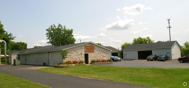
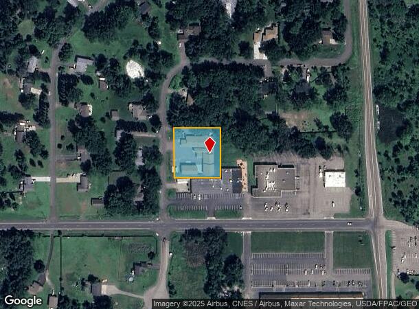
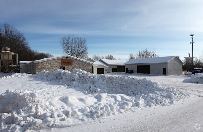
16735 Quicksilver St Nw
Minneapolis-St. Paul-Bloomington, MN-WI
Klemish Add
11-32-25-31-0037
THE N 200 FT OF THE W 187 FT OF LOT 3 BLK 7 KLEMISH ADD SUBJ TO EASE OF REC
Industrialgeneral
Anoka
X
Minnesota
27003C0170E
3
2025
0.86 AC
2025
North Central
050241
Minneapolis/St Paul
9,740 SF
DEMOGRAPHICS near 16735 Quicksilver St Nw
1 Mile
3 Mile
5 Mile
2024 Total Population
2,293
21,983
54,593
2029 Population
2,365
22,781
56,786
Pop Growth 2024-2029
+ 3.14%
+ 3.63%
+ 4.02%
Average Age
40
39
39
2024 Total Households
772
7,489
19,398
HH Growth 2024-2029
+ 3.24%
+ 3.67%
+ 4.09%
Median Household Inc
$142,083
$112,557
$103,728
Avg Household Size
2.90
2.90
2.80
2024 Avg HH Vehicles
3.00
2.00
2.00
Median Home Value
$373,015
$341,182
$335,155
Median Year Built
1986
1993
1991
Nearby Places
Map Layers
Map Styles
 Street
 Aerial
- Restaurants
- Banks
- Shops
- Fitness
- Groceries
PUBLIC TRANSPORTATION
COMMUTER RAIL
DRIVE
WALK
Distance
9 min
4.7 mi
Anoka Station (Northstar Corridor - Northstar Commuter Rail)
DRIVE
WALK
Distance
Anoka Station (Northstar Corridor - Northstar Commuter Rail)
11 min
5.8 mi
AIRPORT
Minneapolis-St Paul International/Wold-Chamberlain
DRIVE
WALK
Distance
Minneapolis-St Paul International/Wold-Chamberlain
56 min
40.6 mi
Nearby Properties
Address
Land Use
TOTAL SIZE
Lot Size
Zoning
Address
Land Use
TOTAL SIZE
Lot Size
Zoning
2,011 SF
34 AC
Address
Land Use
TOTAL SIZE
Lot Size
Zoning
102,938 SF
Address
Land Use
TOTAL SIZE
Lot Size
Zoning
125,349 SF
Address
Land Use
TOTAL SIZE
Lot Size
Zoning
122,762 SF
53.05 AC
Address
Land Use
TOTAL SIZE
Lot Size
Zoning
1,880 SF
4.18 AC
Address
Land Use
TOTAL SIZE
Lot Size
Zoning
1,936 SF
35.53 AC
Address
Land Use
TOTAL SIZE
Lot Size
Zoning
41,472 SF
4.05 AC
Address
Land Use
TOTAL SIZE
Lot Size
Zoning
40,000 SF
2.81 AC
Address
Land Use
TOTAL SIZE
Lot Size
Zoning
41,560 SF
2.55 AC
Address
Land Use
TOTAL SIZE
Lot Size
Zoning
16,236 SF
1.74 AC
Address
Land Use
TOTAL SIZE
Lot Size
Zoning
30,240 SF
2.13 AC
Address
Land Use
TOTAL SIZE
Lot Size
Zoning
12,576 SF
3.14 AC
Address
Land Use
TOTAL SIZE
Lot Size
Zoning
3,520 SF
88.69 AC
Address
Land Use
TOTAL SIZE
Lot Size
Zoning
25,656 SF
1.85 AC
Address
Land Use
TOTAL SIZE
Lot Size
Zoning
17,254 SF
2.35 AC
Address
Land Use
TOTAL SIZE
Lot Size
Zoning
20,408 SF
1.87 AC
Address
Land Use
TOTAL SIZE
Lot Size
Zoning
2,897 SF
35.10 AC
Address
Land Use
TOTAL SIZE
Lot Size
Zoning
8,156 SF
3.36 AC
Address
Land Use
TOTAL SIZE
Lot Size
Zoning
14.46 AC
Address
Land Use
TOTAL SIZE
Lot Size
Zoning
11,525 SF
5.51 AC
Address
Land Use
TOTAL SIZE
Lot Size
Zoning
1,216 SF
40 AC
Address
Land Use
TOTAL SIZE
Lot Size
Zoning
21,436 SF
6.60 AC
Address
Land Use
TOTAL SIZE
Lot Size
Zoning
20,892 SF
5 AC
Address
Land Use
TOTAL SIZE
Lot Size
Zoning
20,790 SF
4.86 AC
Address
Land Use
TOTAL SIZE
Lot Size
Zoning
12,432 SF
0.25 AC
Address
Land Use
TOTAL SIZE
Lot Size
Zoning
12,432 SF
0.22 AC
Address
Land Use
TOTAL SIZE
Lot Size
Zoning
10,982 SF
1.41 AC
Address
Land Use
TOTAL SIZE
Lot Size
Zoning
1,823 SF
40 AC
Address
Land Use
TOTAL SIZE
Lot Size
Zoning
17,816 SF
2.09 AC
The World's #1 Commercial Real Estate Marketplace
Connect with us
© 2026 CoStar Group
The information above has been obtained from sources believed reliable. While we do not doubt its accuracy we have not verified it and make no guarantee, warranty or representation about it. It is your responsibility to independently confirm its accuracy and completeness. Any projections, opinions, assumptions, or estimates used are for example only and do not represent the current or future performance of the property. The value of this transaction to you depends on tax and other factors which should be evaluated by your tax, financial, and legal advisors. You and your advisors should conduct a careful, independent investigation of the property to determine to your satisfaction the suitability of the property for your needs.