Property Record
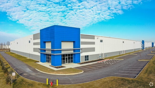
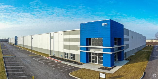
1675 Beggrow St, Lockbourne, OH 43137

Property Detail
1675 Beggrow St
495-300107
LONDON GROVEPORT RD R22 T4 1/4T36 22.9243 ACRES
Industrialgeneral
Franklin
B and X Area of moderate flood hazard, usually the area between the limits of the 100-year and 500-year floods.
Ohio
2024
22.92 AC
2025
Southeast
009590
Columbus
261,000 SF
Columbus, OH
NEARBY LISTINGS FOR SALE OR LEASE
DEMOGRAPHICS near 1675 Beggrow St
1 mile
3 mile
5 mile
2025 Total Population
2,801
11,836
48,062
2030 Population
2,940
12,326
49,713
Pop Growth 2025-2030
+ 4.96%
+ 4.14%
+ 3.44%
Average Age
32
38
39
2025 Total Households
890
4,280
17,930
HH Growth 2025-2030
+ 5.06%
+ 4.23%
+ 3.50%
Median Household Inc
$58,487
$66,509
$73,113
Avg Household Size
3.20
2.80
2.60
2025 Avg HH Vehicles
2.00
2.00
2.00
Median Home Value
$251,754
$227,530
$227,868
Median Year Built
1961
1975
1978
Nearby Places
Map Layers
Map Styles
 Street
 Aerial
Layers
 Traffic
 Biking
Places
Listings with unknown addresses are not visible on the map
- Restaurants
- Banks
- Shops
- Fitness
- Groceries
PUBLIC TRANSPORTATION
AIRPORT
Rickenbacker International
Drive
Walk
Distance
Rickenbacker International
7 min
2.8 mi
John Glenn Columbus International
Drive
Walk
Distance
John Glenn Columbus International
28 min
16.6 mi
Freight Ports
Port of Toledo
Drive
Walk
Distance
Port of Toledo
203 min
150.5 mi
SALE & LEASE HISTORY
LISTING DATE
SALE/LEASE

Oct 23, 2019
For Lease
Nearby Properties
Address
Land Use
TOTAL SIZE
Lot Size
Zoning
Address
Land Use
TOTAL SIZE
Lot Size
Zoning
4,200 SF
852.55 AC
Address
Land Use
TOTAL SIZE
Lot Size
Zoning
284,628 SF
167.80 AC
Address
Land Use
TOTAL SIZE
Lot Size
Zoning
1,075,600 SF
49.33 AC
Address
Land Use
TOTAL SIZE
Lot Size
Zoning
1,466,512 SF
49.72 AC
Address
Land Use
TOTAL SIZE
Lot Size
Zoning
43,254 SF
300.98 AC
Address
Land Use
TOTAL SIZE
Lot Size
Zoning
20,888 SF
181 AC
Address
Land Use
TOTAL SIZE
Lot Size
Zoning
1,054,500 SF
59.77 AC
Address
Land Use
TOTAL SIZE
Lot Size
Zoning
1,219,000 SF
59.32 AC
Address
Land Use
TOTAL SIZE
Lot Size
Zoning
1,021,020 SF
68.44 AC
Address
Land Use
TOTAL SIZE
Lot Size
Zoning
1,600,052 SF
70.19 AC
Address
Land Use
TOTAL SIZE
Lot Size
Zoning
977,584 SF
70.14 AC
Address
Land Use
TOTAL SIZE
Lot Size
Zoning
1,280,501 SF
69.60 AC
Address
Land Use
TOTAL SIZE
Lot Size
Zoning
150.29 AC
Address
Land Use
TOTAL SIZE
Lot Size
Zoning
816,200 SF
51.08 AC
Address
Land Use
TOTAL SIZE
Lot Size
Zoning
959,688 SF
55.34 AC
Address
Land Use
TOTAL SIZE
Lot Size
Zoning
778,272 SF
42.31 AC
Address
Land Use
TOTAL SIZE
Lot Size
Zoning
903,780 SF
45.43 AC
Address
Land Use
TOTAL SIZE
Lot Size
Zoning
720,200 SF
35.71 AC
Address
Land Use
TOTAL SIZE
Lot Size
Zoning
785,854 SF
30.85 AC
Address
Land Use
TOTAL SIZE
Lot Size
Zoning
676,000 SF
35.76 AC
Address
Land Use
TOTAL SIZE
Lot Size
Zoning
Address
Land Use
TOTAL SIZE
Lot Size
Zoning
592,120 SF
38.67 AC
Address
Land Use
TOTAL SIZE
Lot Size
Zoning
547,200 SF
43.58 AC
Address
Land Use
TOTAL SIZE
Lot Size
Zoning
541,910 SF
36.84 AC
Address
Land Use
TOTAL SIZE
Lot Size
Zoning
639,600 SF
43.91 AC
Address
Land Use
TOTAL SIZE
Lot Size
Zoning
743,315 SF
42.17 AC
Address
Land Use
TOTAL SIZE
Lot Size
Zoning
567,000 SF
23.08 AC
Address
Land Use
TOTAL SIZE
Lot Size
Zoning
130,865 SF
9.97 AC
Address
Land Use
TOTAL SIZE
Lot Size
Zoning
767,697 SF
39.49 AC
Address
Land Use
TOTAL SIZE
Lot Size
Zoning
655,288 SF
40.76 AC
The World's #1 Commercial Real Estate Marketplace
Connect with us
© 2026 CoStar Group
The information above has been obtained from sources believed reliable. While we do not doubt its accuracy we have not verified it and make no guarantee, warranty or representation about it. It is your responsibility to independently confirm its accuracy and completeness. Any projections, opinions, assumptions, or estimates used are for example only and do not represent the current or future performance of the property. The value of this transaction to you depends on tax and other factors which should be evaluated by your tax, financial, and legal advisors. You and your advisors should conduct a careful, independent investigation of the property to determine to your satisfaction the suitability of the property for your needs.