Property Record
1675 State Route 17K, Montgomery, NY 12549
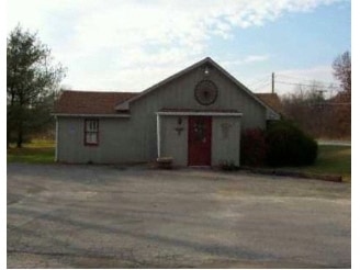

Property Detail
1675 State Route 17K
334289-028-000-0001-005.000-0000
TOWN PARK
Parkplaygroundpicnicarea
ORANGE
RA-.5
New York
AE The base floodplain where base flood elevations are provided. AE Zones are now used on new format FIRMs instead of A1-A30 Zones.
5.000
0
102.40 AC
2025
Middletown
010601
Northern New Jersey
2,160 SF
Kiryas Joel-Poughkeepsie-Newburgh, NY
NEARBY LISTINGS FOR SALE OR LEASE
-
-
View all Montgomery listings for sale on LoopNet.com
DEMOGRAPHICS near 1675 State Route 17K
1 mile
3 mile
5 mile
2025 Total Population
971
9,033
26,164
2030 Population
987
9,168
26,585
Pop Growth 2025-2030
+ 1.65%
+ 1.49%
+ 1.61%
Average Age
41
41
40
2025 Total Households
343
3,182
9,312
HH Growth 2025-2030
+ 1.75%
+ 1.57%
+ 1.70%
Median Household Inc
$103,472
$116,481
$107,633
Avg Household Size
2.80
2.70
2.70
2025 Avg HH Vehicles
2.00
2.00
2.00
Median Home Value
$418,254
$436,378
$395,962
Median Year Built
1970
1979
1976
Nearby Places
Map Layers
Map Styles
 Street
 Aerial
Layers
 Traffic
 Biking
Places
Listings with unknown addresses are not visible on the map
- Restaurants
- Banks
- Shops
- Fitness
- Groceries
PUBLIC TRANSPORTATION
COMMUTER RAIL
Campbell Hall (Bergen County/Port Jervis Line - NJ Transit Commuter Rail (NJ Transit), Main/Port Jervis Line - NJ Transit Commuter Rail (NJ Transit))
Drive
Walk
Distance
Campbell Hall (Bergen County/Port Jervis Line - NJ Transit Commuter Rail (NJ Transit), Main/Port Jervis Line - NJ Transit Commuter Rail (NJ Transit))
15 min
8.4 mi
AIRPORT
New York Stewart International
Drive
Walk
Distance
New York Stewart International
18 min
10.9 mi
Freight Ports
Port Newark Container Terminal
Drive
Walk
Distance
Port Newark Container Terminal
102 min
77.0 mi
Nearby Properties
Address
Land Use
TOTAL SIZE
Lot Size
Zoning
Address
Land Use
TOTAL SIZE
Lot Size
Zoning
1,332,075 SF
118 AC
I1
Address
Land Use
TOTAL SIZE
Lot Size
Zoning
1,040,580 SF
70.80 AC
ID
Address
Land Use
TOTAL SIZE
Lot Size
Zoning
513,951 SF
112.80 AC
ID
Address
Land Use
TOTAL SIZE
Lot Size
Zoning
249,128 SF
43.72 AC
ID
Address
Land Use
TOTAL SIZE
Lot Size
Zoning
340,782 SF
37 AC
LUI
Address
Land Use
TOTAL SIZE
Lot Size
Zoning
760,927 SF
51.60 AC
ID
Address
Land Use
TOTAL SIZE
Lot Size
Zoning
312,980 SF
42.30 AC
ID
Address
Land Use
TOTAL SIZE
Lot Size
Zoning
108.50 AC
Address
Land Use
TOTAL SIZE
Lot Size
Zoning
366,680 SF
32.10 AC
Address
Land Use
TOTAL SIZE
Lot Size
Zoning
121,460 SF
42.70 AC
ID
Address
Land Use
TOTAL SIZE
Lot Size
Zoning
Address
Land Use
TOTAL SIZE
Lot Size
Zoning
103,857 SF
14.30 AC
B4
Address
Land Use
TOTAL SIZE
Lot Size
Zoning
26,500 SF
27.50 AC
B4
Address
Land Use
TOTAL SIZE
Lot Size
Zoning
90,200 SF
7.50 AC
B4
Address
Land Use
TOTAL SIZE
Lot Size
Zoning
103,079 SF
30.60 AC
ID
Address
Land Use
TOTAL SIZE
Lot Size
Zoning
82,464 SF
3.80 AC
B4
Address
Land Use
TOTAL SIZE
Lot Size
Zoning
49,056 SF
20 AC
RM1
Address
Land Use
TOTAL SIZE
Lot Size
Zoning
48,131 SF
2.80 AC
B4
Address
Land Use
TOTAL SIZE
Lot Size
Zoning
Address
Land Use
TOTAL SIZE
Lot Size
Zoning
10,433 SF
334.40 AC
I1
Address
Land Use
TOTAL SIZE
Lot Size
Zoning
63,139 SF
5.40 AC
Address
Land Use
TOTAL SIZE
Lot Size
Zoning
62,557 SF
37.20 AC
ID
Address
Land Use
TOTAL SIZE
Lot Size
Zoning
88,416 SF
4.20 AC
R2
Address
Land Use
TOTAL SIZE
Lot Size
Zoning
22,062 SF
16.40 AC
ID
Address
Land Use
TOTAL SIZE
Lot Size
Zoning
89,916 SF
22.30 AC
ID
Address
Land Use
TOTAL SIZE
Lot Size
Zoning
50,652 SF
6 AC
I1
Address
Land Use
TOTAL SIZE
Lot Size
Zoning
731,864 SF
43.70 AC
I
Address
Land Use
TOTAL SIZE
Lot Size
Zoning
33,093 SF
3.80 AC
ID
Address
Land Use
TOTAL SIZE
Lot Size
Zoning
18,270 SF
5.50 AC
RM1
Address
Land Use
TOTAL SIZE
Lot Size
Zoning
39,158 SF
20.50 AC
01
The World's #1 Commercial Real Estate Marketplace
Connect with us
© 2026 CoStar Group
The information above has been obtained from sources believed reliable. While we do not doubt its accuracy we have not verified it and make no guarantee, warranty or representation about it. It is your responsibility to independently confirm its accuracy and completeness. Any projections, opinions, assumptions, or estimates used are for example only and do not represent the current or future performance of the property. The value of this transaction to you depends on tax and other factors which should be evaluated by your tax, financial, and legal advisors. You and your advisors should conduct a careful, independent investigation of the property to determine to your satisfaction the suitability of the property for your needs.